Tag Archives: Lanier County

Pictures: Lakeland to Hotchkiss Road, WWALS Outing –Gretchen Quarterman 2015-07-11

Update 2023-06-22: More Pictures: WWALS on The Rocks between Lakeland and Hotchkiss, Alapaha River 2015-07-11.

Pictures by Gretchen Quarterman of the 11 July 2015 WWALS outing on the Alapaha River. 11709767_999285253417010_7438073058688354664_n.jpg Happy paddlers and an owl!

Lots more outings coming up, from the Little River to the Suwannee, the Alapaha again (continuing our exploration of the Alapaha River Water Trail), to Grand Bay, the Okefenokee Swamp, and of course the Withlacoochee River, where we went most recently last month.

-jsq

You can join this fun and work by becoming a WWALS member today!

From Gretchen’s facebook album.

Gretchen Quartermans photo. Continue reading

Rained out: Banks Lake Outing cancelled 2015-08-29

Expedition leader Chris Mericle conferred with John at Banks Lake Outdoors, Intellicast: South Georgia and they agree nobody wants boaters on Banks Lake in a thunderstorm, so tonight’s outing is cancelled. You probably figured that out already anyway, what with rain for an hour or more now and a 70% chance of thundersshowers at 7PM.

Chris would like to reschedule for Continue reading

Video: Steam engine, bridges, trees, beaches, and trash: Alapaha River by Diane Shearer

Also boating, deadfalls, steam engine, and rapids. Diane Shearer presented slides about the Alapaha River of her homeland, 31 March 2012 at Georgia River Network Weekend for Rivers, and said:

Right there at Alapaha, where it’s been clearcut behind it. This is one of the main problems of the river: there used to be nothing on that shore there but huge cypress trees and tupelo trees, and that’s almost gone everywhere. And that’s one of the great dangers to this river, is agricultural runoff, the fact that people can suck all the water out of it they want to, for irrigation and those sorts of things.

The video starts Continue reading

Banks Lake Full Moon Paddle: bring bon-bons! 2015-08-29

Bring bon-bons, lights, and boats to Banks Lake, just west of Lakeland, Georgia, 300x225 Evening falls, in Banks Lake Full Moon, by John S. Quarterman, 13 June 2014

7PM Saturday
August 29th 2015

for the first WWALS Moonlight Paddle and Bon-Bon Eating Contest. Your host, Chris Mericle, has arranged a special after-hours permit for this outing. Join us at

Banks Lake Outdoors,
1099 W Main St.,
Lakeland, GA 31635.

This is part of our continuing exploration of the Alapaha River Water Trail. Printable PDF flyer. facebook event.

Strictly speaking, a bon-bon is Continue reading

Burnt Church in Lakeland to Hotchkiss in Stockton –Chris Graham 2015-06-20

Alapaha River Water Trail Committee Chair Chris Graham went with a few friends down the middle section of this Blueway:

Which is roughly 12 river miles. It was amazing epic river trip. Continue reading

WWALS Goals for 2015

Boating on our rivers and water trails for them, issues and education: you can help with the fun and work of WWALS! Here’s much of what can be done laid out in a list of a dozen WWALS Goals for 2015. The board has at least one opening right now, and the committees always could use more members. You can apply through the online form.

See also the monthly newsletter, the news about WWALS, and of course the website with blog, facebook the page and group, and WWALS on twitter, Youtube, and the membership google group. You can become a member or corporate sponsor of WWALS online right now.

The WWALS Executive Committee 11 March 2015 recommended Continue reading

Lanier Park to CSX RR track Hotchkiss Road, WWALS outing 2015-07-11

Update 10 July 2015: 
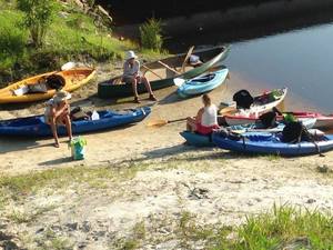
Outing leader Chris Graham says there’s plenty of water, so we’ll be putting in on the Alapaha River tomorrow morning at Lanier Park. However, he says we’ll be taking out at Hotchkiss Road (instead of CSX RR), so about 14 miles or seven hours. Bring your lunch and plenty of water. See you at 8AM. -jsq

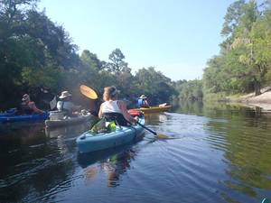
Breeze over mild rapids past sand beaches on the Alapaha River, from Lakeland to US 84.

It’s long, but there should be no deadfalls. In most places the river may be so low you could stand up, but as always bring your personal flotation device.

When: 8AM Saturday, July 11th, 2015
What: 15 mile paddle from Lanier Park to CSX RR track on the public right way.
Duration: 7-8 hours, after a 30 minute shuttle
Directions: Highway 122 about 1.5 miles west of Lakeland, GA, turn south on unmarked dirt road just west of river to ramp.
Responsible party: Chris Graham

This event is FREE! All we ask is that you are a current member of WWALS Watershed Coalition. If not, it’s easy Continue reading

New outfitter: Banks Lake Outdoors Experience

300x159 ARWT Lakeland, in Alapaha River Water Trail, by John S. Quarterman, for WWALS.net, 27 March 2015 U.S. Fish and Wildlife Service PR of 11 February 2015, New Partnership Announced for Concession Operation at Banks Lake NWR

Folkston, GA… Okefenokee National Wildlife Refuge is proud to announce the ground-breaking partnership that will aid in the operation and visitor services of the Banks Lake National Wildlife Refuge in Lakeland, GA. An unstaffed refuge, Banks Lake is administered by Okefenokee, nearly 120 miles away, making work at this remote refuge often difficult. Refuge staff will now be working with Lanier County to aid in the concession operation and visitor services offered at Banks Lake. “I am excited Lanier County has the opportunity for this partnership with the Banks Lake National Wildlife Refuge and the Lakeland-Lanier Chamber” said Alex Lee, Lanier County Board of Commissioners Chairman. “Our board is ready to make this happen.”

Continue reading

Alapaha River precipitation and levels

300x153 90 Days Levels Graph, in Alapaha River Levels and Precipitation, by USGS, for WWALS.net, 7 March 2015 Rainfall can be quite different in Statenville on the Alapaha River as shown here than in Valdosta on the Withlacoochee River. But remember half of Valdosta drains into the Alapaha River watershed.

Here are rainfall and water level graphs from the three USGS Alapaha River gauges in Georgia. The Florida gauge is shown separately, because it use a different base level, and precipitation doesn’t seem to be available from Florida gauges. See also always-current graphs of all the levels. Continue reading