Tag Archives: Mike Fletcher

2021 ANNUAL REPORT, Lowndes County Impaired Streams Monitoring 2021-04-07

Update 2023-09-26: ANNUAL REPORT, Lowndes County Impaired Streams Monitoring 2022-04-07.

After two years, Lowndes County has still not found sources of the fecal contamination in its streams. Maybe the testing methodology needs to be revised.

Fortunately, WWALS is covering part of what the county does not: WWALS is testing for E. coli after big rains on Cat Creek and Beatty Branch and multiple Withlacoochee, Little, and Alapaha River locations, and we are doing some DNA spot tests.

Fecal Coliform
Lowndes County has not identified any point sources within the drainage areas that can be attributed to the widespread exceedances. Based on the limited data collected to date, it is the opinion of Lowndes County that the cause of the exceedances is from natural conditions.

[Map and graphs]
Map and graphs

There are no DNA marker or chemical tracer results in the report. A few DNA tests would have given some indication of what species were producing the fecal contamination.

Also, the report includes no Continue reading

2020 ANNUAL REPORT, Lowndes County Impaired Streams Monitoring 2020-04-07

Update 2022-08-23: 2021 ANNUAL REPORT, Lowndes County Impaired Streams Monitoring 2021-04-07.

Some good news: “Low level mercury levels are well below acute standards at all sampling points.”

Some bad news: “fecal coliform sampling results indicated all sampling points exceeded water quality standards for the June and September sampling events.”

[Cover, Franks Creek and Mud Creek]
Cover, Franks Creek and Mud Creek

That’s in the 2020 ANNUAL REPORT from Lovell Enginnering Associates to Lowndes County for its Impaired Streams Monitoring project that the Georgia Environmental Protection Division (GA-EPD) required the county to do.

Thanks to Lowndes County Engineer Mike Fletcher for sending this report in response to a WWALS open records request. I don’t know why Lowndes County did not publish this report themselves. Maybe they did, and I just haven’t found it online yet.

Working through this data, so far it seems that Franks Creek, which comes down west of Hahira to the Little River, shows spikes in Fecal coliform after rains. Those spikes usually occur downstream of Hahira’s wastewater treatment facility. Continue reading

Stream monitoring with only annual reporting privatized by Lowndes County Commission 2020-04-28

With only one dissenting vote, last night the Lowndes County Commission approved more than $45,000 for a sole-source contract for stream monitoring, with only annual reporting required. Since the contractor is private, it doesn’t have to answer open records requests. How does this help warn people when the rivers are clean or not?

There had never been any bids, even though the requirement for this monitoring from GA-EPD apparently came in back in June 2018. The Commissioners did not have the monitoring plan in front of them, nor the GA-EPD requirement, as near as I can tell.

[BUDGET IMPACT: $45,120.00 2020-04-28]
BUDGET IMPACT: $45,120.00 2020-04-28
PDF

Apparently somebody read a list of streams to the Commissioners, along with the monitoring required for each. But that list was not in the posted agenda.

[Suwannee Basin impaired waters, map]
Suwannee Basin impaired waters, map by GECAP.

We can guess it was maybe the “Not Supporting” or “Assessment Pending” streams in Lowndes County from the GA-EPD Listing of Waterbodies, Clean Water Act Section 303(d), for which see below. But we don’t know.

And what about the contamination often coming down Okapilco Creek into GAR031102030902 Withlacoochee River: Okapilco Creek to Stateline? No Commissioner thought to ask that. How will this contractor work with WWALS? Perhaps an indication came when I spoke with the County Engineer Mike Fletcher Monday morning: “I don’t know what WWALS is doing,” he said.

Did Lowndes County consult with any of the various organizations that are doing stream monitoring already, such as the cities of Valdosta or Quitman, Madison Health, FDEP, SRWMD, or SGRC? If so, they didn’t mention it in last night’s meeting.

It is not even clear that this was a public meeting. At 2:38 PM, less than three hours before Continue reading

Naylor Boat Ramp poured 2019-04-30

Update 2019-05-08: Now with framing and concrete wire.

Update 2019-05-06: OK, as April Huntley pointed out after went out there over the weekend, the concrete is not poured yet: what’s out there is the bed on which to put the concrete. I called Lowndes County Project Manager Chad McLeod, who said that’s right. Today the forms for the concrete are in place. Probably Wednesday they will pour the concrete. Then it has to set for 10-14 days. After that, they will pick a day with an appropriate river level (they need a couple of feet of water in the river), and they will slide the segments down the ramp into the river. So probably somewhere between 18 and 25 May 2019 the concrete ramp should be in the river.

Some of the concrete was still setting on the new Naylor Boat Ramp on the Alapaha River just upstream from US 84.

[From the top]
From the top

Lowndes County Commissioner Joyce Evans asked Gretchen Quarterman at the Monday Planning Commission meeting whether she had been to the new Naylor Boat Ramp. Continue reading

Alapaha River Boat Ramp

These are the maps Lowndes County Engineer Mike Fletcher presented at the Naylor Town Hall 2016-04-14. Roads and parking lot Bret Huntley asked him to send them, and he did.

These have more detail than Continue reading

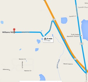
Bevel Creek, not Beaty Creek, on Williams Road off Loch Laurel, Lowndes County, Georgia

Mystery finally solved of where is the road over what creek does Lowndes County Georgia want to replace a bridge?

Loch Laurel Road to Williams Road --Google Maps Item 6.b. Replacement of Beatty Creek Bridge on Williams Road, for yesterday morning’s Lowndes County Commission Work Session: where is this for the $634,800 low bid from Southern Concrete Construction of Albany, GA? There are two Williams Roads in Lowndes County and no Beaty Creek. In the north end of the county Cat Creek has a tributary Beatty Mill Creek, with a Williams Road running near it between Upper New Bethel Road and Beatty Mill Creek Road. But according to all the maps I can find, Williams Road does not cross Beatty Mill Creek.

So what exactly is it that the county wants to pay the low bidder $634,800 for? In the 8:30 AM Tuesday 25 April 2016 Work Session, Commissioner Mark Wisenbaker asked, “Where exactly is this?” Continue reading

Naylor Park and Boat Ramp aerial plan map

300x186 Naylor Boat Ramp aerial, in Maps from board packet, by John S. Quarterman, 10 February 2015 Thanks to the Lowndes County Commission and staff, here’s a look at what they’re planning for the new boat ramp and park on the Alapaha River just north of US 84. Below are videos of discussion about these plans in several recent Commission meetings. This boat ramp and park is already on the map for the Alapaha River Water Trail, and I have thanked the Commission for moving along to get it established; see below. Continue reading