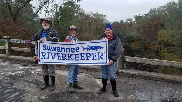
We made it to Spook Bridge from US 84! It was a small group, four of us, on a cold November afternoon. And we saw the sad remains of Wade Spring.
Paddling upstream was not practicable, Continue reading

We made it to Spook Bridge from US 84! It was a small group, four of us, on a cold November afternoon. And we saw the sad remains of Wade Spring.
Paddling upstream was not practicable, Continue reading
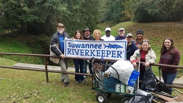
Good turnout for the One Mile Branch Cleanup at VSU, including the new Valdosta Utilities Director, Darryl Muse, and his wife. Thanks Scotti Jay for organizing this outing, including bringing a cart for the materials and going back with a pickup truck to collect the bags of trash.
There were waterfalls just like Scotti said, Tom Potter fished a lawn chair out of the creek, we celebrated Armistice Day, we took some pictures with the Suwannee Riverkeeper banner, and we heard a word from Valdosta’s Utilities Director, all in addition to picking up a lot of trash for two hours on a cold windy November day.
Update 2018-11-09: Pictures.
We will have the WWALS festival booth at the Alapaha Station Celebration on Saturday November 11, for the fourth year running. Join us for a fun day of outreach to members of our community.
When: 9AM – 5PM, Saturday, November 11, 2017
Where: Alapaha Station, 245 NE Railroad St, Alapaha, Georgia
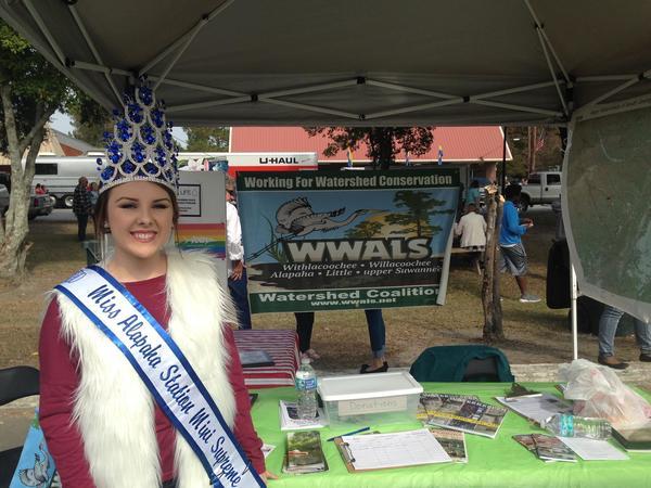
Miss Alapaha Station Mini Supreme at the WWALS booth last year.
The station is only a few miles from Continue reading
Last year at Alapaha Station Celebration we met a lot of people ad had a good time. We’ll be back there this Saturday.

Next Tuesday in Live Oak, the latest on BMAPs.
To: Suwannee River Basin BMAP Stakeholders
From: Terry Hansen, Basin CoordinatorReminder: A meeting for the Lower and Middle Suwannee River, Withlacoochee River, and associated springs Basin Management Action Plan (BMAP) is scheduled for November 14th, 2017. Note that everyone is welcome to attend. The primary purpose of this meeting is to discuss and receive comments on the draft BMAP document. The Department requests that you please submit any comments on the draft document by COB Thursday, November 30th, 2017.
Tuesday, November 14, 2017
6:00 PM,
Suwannee River Water Management District
9225 CR49
Live Oak, FL 32060

Photo: John S. Quarterman, from BMAPs: Agriculture and water at the Suwannee River Basin crossroads 2017-04-13A meeting agenda Continue reading
Irony: Duke Energy is building a 75 megawatt solar farm right next to the Sabal Trail pipeline, of which Duke is a 7.5% owner.
Dust no more! The same place Chris Mericle reported having a dust storm little more than a week ago, last week he discovered Duke Energy is replacing the center pivots with solar panels.
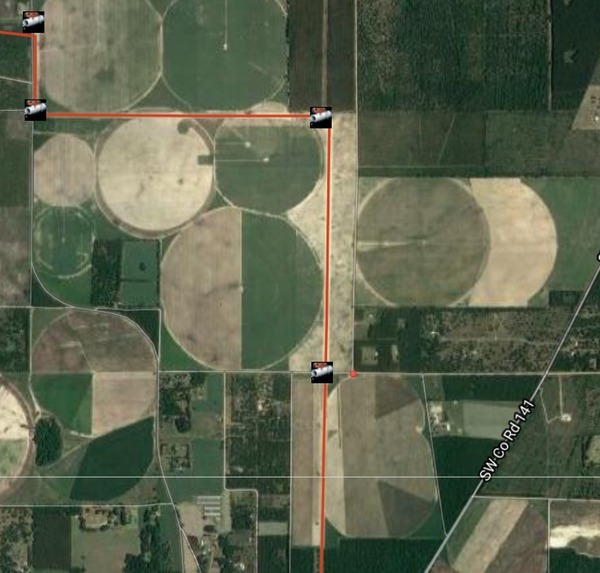
SW 69th Drive and SW 40th Avenue, in Sabal Trail path digitized by WWALS.
The little red dot near the center of the above map is where Duke Energy says this solar farm will go. The red line is the Sabal Trail pipeline, next to the power line Duke will be using for the solar electricity. How about turn off the pipeline, Duke, and put solar panels along its right of way? As I computed using Sabal Trail’s own figures three and a half years ago, half that RoW acreage could generate just as much electricity from the sun as that pipeline would ever produce, and solar panel prices have gone down since then.
Duke Energy Florida, unknown date, Hamilton Solar Plant, Continue reading
After the One Mile Branch Cleanup at VSU, let’s head west on US 84 to the Withlacoochee River and paddle (or hike) downstream to Spook Bridge: if you’ve seen the locally-made movie, come see the bridge! In between we may see the river part of Wade Spring, and we will see the railroad bridge and the old, closed, Blue Springs road bridge, aka Spook Bridge. Then we will paddle (or hike) upstream to the Sabal Trail pipeline crossing, also less than a quarter mile. If you don’t want to do either, we will tell you how to get to Spook Bridge by land to greet us when we get there.
When: 1PM, Saturday, November 11, 2017
Put In:
US 84, park between the bridges on the Lowndes County side.
We will climb down the steep rocky embankment between the bridges,
seen from the Brooks County side in this picture:
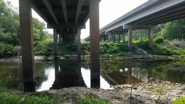
Photo: John S. Quarterman,
From Brooks County to Lowndes County, under the US 84 bridge, 85.2 on the Quitman Gauge, May 22, 2017.
Anyone in reasonable shape can climb it.
Bring: mud boots, plus the usual personal flotation device, boat paddles, food, drinking water, warm clothes, and first aid kit. Also trash pickers and trash bags: every WWALS outing is also a cleanup.
Free: This outing is Free! And we recommend you support the work of WWALS by becoming a WWALS member today!
Event: facebook, meetup Continue reading
Update 2018-01-19: Rescheduled again, due to low water, to become a hike to the Dead River Sink, still on January 27, 2018.
Update 2018-01-01: Rescheduled to January 27, 2018! Follow this link for the revised outing details.
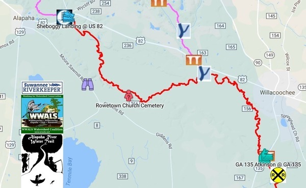
A long paddle to start the Alapaha Quest! Along the way we will pass Rowetown Church and the Willacoochee River Confluence as we paddle down the wild and exotic Alapaha River in the south Georgia winter.
When: 7AM Saturday, January 6, 2018
Put In: Sheboggy Landing at US 82, east of Alapaha, Berrien County, Georgia.
Take Out: GA 135 Atkinson near Willacoochee, GA in Atkinson County.
Price: This outing is $10.00 for nonmembers, and free to WWALS members. We recommend you support the work of WWALS by becoming a WWALS member today!
Bring: Continue reading
Update 2018-01-19: First leg rescheduled again, due to low water, to become a hike to the Dead River Sink, still on January 27, 2018.
Update 2018-01-01: The first leg of the Alapaha Quest is rescheduled to January 27, 2018! Follow this link for the revised details of that outing.
Join us to explore the entire Alapaha River Water Trail on the 2018 Alapaha Quest!
The Alapaha River is described as unspoiled, wild, and scenic. Add these remoteness features, some the dark reddish-brown waters with occasional shoals and it becomes a gem to paddle.

What is the Alapaha Quest?
Continue reading
Noah Valenstein, formerly SRWMD, now FDEP Secretary, has appointed Eric Draper of Audubon Florida to head Florida State Parks. The same Eric Draper who twice endorsed Sabal Trail in writing, and did nothing to stop Sabal Trail from drilling under the Suwannee, Santa Fe, or Withlacoochee (South) Rivers, nor under the Suwannee River State Park that he will now oversee.
Walton Outdoors, Blog, 2 November 2017, Audubon Florida’s former executive director Eric Draper now director of Florida State Parks,
TALLAHASSEE, Fla. — Florida Department of Environmental Protection Secretary Noah Valenstein today announced three key appointments to DEP’s leadership team, as part of its continued focus on the protection of Florida’s prized properties through the management of Florida’s world-renowned state park system and land acquisition and conservation. Eric Draper will join the DEP team as the Director of Florida State Parks, effective Nov. 28, and Callie DeHaven will serve as Interim Director of the Division of State Lands effective Nov. 27, subject to Governor and Cabinet confirmation. David Clark, who has previously served as Director of State Lands and has been acting Deputy Secretary of Land and Recreation, has officially been appointed Deputy Secretary.

Aerial west across FL 200, down Withlacoochee (South) River, across Sabal Trail Marion County drill site, and Halpata Tastanaki Preserve. Photo by Jim Tatum on WWALS Southwings flight 7 February 2017.As Florida State Parks Director, Draper will Continue reading