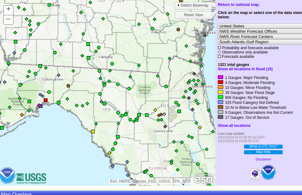
Another mysterious rise of bacterial counts at Horn Bridge, at Mozell Spells, near State Line Ramp, Withlacoochee River, in the latest data from Valdosta, from Wednesday, December 5, 2018, obtained as usual through open records request.


Another mysterious rise of bacterial counts at Horn Bridge, at Mozell Spells, near State Line Ramp, Withlacoochee River, in the latest data from Valdosta, from Wednesday, December 5, 2018, obtained as usual through open records request.
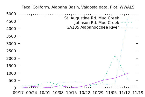
The Alapahoochee River at the GA-FL line measured ten times the EPA limit on Fecal coliform again this Wednesday, November 28, 2018.

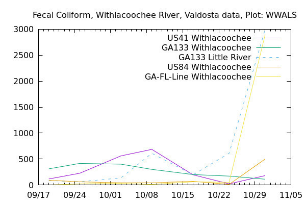
It does not seem to be coming downriver from Valdosta. Continue reading
Suddenly, all the fecal coliform readings are down. Was there a first flush from the rain on November 14 that caused the high readings of that day, and all that washed down the rivers within a week?
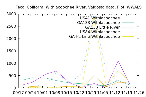
At US 41 (North Valdosta Road), the Withlacoochee River was actually in minor flood several of the intervening days, according to the USGS US 41 (Valdosta) Gauge. Continue reading
Twenty five times the state limit for Fecal coliform could be a problem. What got into the Alapahoochee River last week?
If you want to help find out what’s getting into our rivers, you can Continue reading
Was there rain Wednesday? That might explain the sudden spikes at US 41 on the Withlacoochee River, at GA 133 on the Little River, and at State Line on the Withlacoochee River. We can guess that the rains Thursday and Friday (today) have washed away whatever that very odd spike was at the state line.
Thanks to Valdosta Utilities and Valdosta City Clerk Teresa Bolden for sending this Wednesday’s Valdosta water quality testing data before the end of Friday. For more contact, see https://wwals.net/issues/vww/.
It’s a very odd spike, because Continue reading
Valdosta’s bacterial counts are always low at State Line Ramp (Mozell Spells), where we moved the WWALS Boomerang paddle race from Georgia to Florida and back.
Things were generally better last week in the Withlacoochee Basin, except for the Little River at GA 133, just above Troupville Boat Ramp. Continue reading
Thursday morning, the day after Hurricane Michael passed by to the west and north of the Suwannee River Basin, only Gopher River and the New River gauge near Lake Butler were in Action Stage.
Does a place that nearly floods even when a hurricane is a hundred miles west of it seem like a good location for the HPS II phosphate mine, in Union and Bradford Counties, Florida ? Continue reading
A fine fall day with diving and landowners at Arnold Springs, Old Clyattville Road Bridge, exotic invasive Japanese Climbing Fern, Horn Bridge, and Mozell Spells (State Line Ramp): on the Withlacoochee River with WWALS Watershed Coalition, Suwannee Riverkeeper. Thanks to all who came to paddle from as far as two hours from Gainesville, Florida and four hours from Pine Mountain, Georgia.
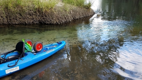
Blue-green Arnold Springs water meets tea-colored Withlacoochee River water.
The Quitman Gauge (US 84) read 2.17 feet (85.67 NAVD88), which was slightly above our recommended low level, and just fine for Arnold Springs. Here are some pictures and a Google Map. A few videos will follow.
This part of the outing was all in Georgia, but we paddled downstream from Florida to get there; see Continue reading
Paddling down the Withlacoochee River from Nankin to Mozell Spells, the remains of the Valdosta Railway Bridge mark on the right bank the north end of the Four Freedoms Trail, one of the few hiking trails on the Withlacoochee and Little River Water Trail (WLRWT):

Photo: John S. Quarterman for WWALS, 9 July 2016.
The Four Freedoms Trail in Madison County was constructed as a joint effort between Continue reading
Now also a Rivers Alive cleanup in conjunction with Keep Lowndes-Valdosta Beautiful (KLVB). You can clean up, or clean up and paddle! Best to bring a rope for your boat: the Withlacoochee River is low, and there may be a few spots of dragging over shoals.
Through KLVB: Call (229)671-3698 to be assigned to Nankin Landing or another location.
Through WWALS: Come on down to Nankin Boat Ramp 9AM Saturday October 14, 2017!

Where: 6899 Clyattville-Nankin Rd, Valdosta, GA 31601, in Lowndes County, 30.675192, -83.394143
Details: See Continue reading