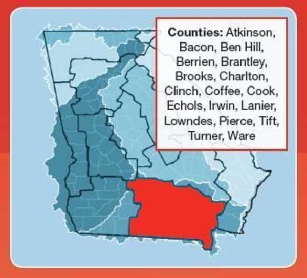
Tag Archives: Willacoochee River

WWALS Quarterly Board Meeting 2020-01-12

Announcement
WWALS Quarterly Board Meeting

2 to 4 PM, Sunday, 12 January 2020
South Georgia Regional Library, 2906 Julia Dr, Valdosta, GA 31602
Dial-in Number: (712) 770-5505
Meeting ID: 855-676
facebook event

Outings in Santa Fe River subbasin, on the Suwannee, and at Banks Lake, Light Parade, Gear Swap, BIG Little River Paddle Race, finances, budget, membership, water quality monitoring, water trails, Suwannee Riverkeeper Songwriting Contest, WWALS Boomerang paddle race, festivals, projects and programs, pipelines, LNG export, titanium mines, phosphate mines, Bill of Rights for Nature, and more.

[WWALS Logo]
WWALS Logo. Yes, S now stands for both Santa Fe and Suwannee, like A stands for both Alapaha and Alapahoochee, and L stands for both Little Rivers (one flowing into the Withlacoochee, the other into the Suwannee).
Our many rivers include four (Alapaha, Withlacoochee, Santa Fe, and Suwannee Rivers), six (plus New and Little Rivers flowing into the Withlacoochee), ten (plus Willacoochee, Alapahoochee, and Little Alapaha Rivers flowing into the Alapaha, and Dead River flowing out of it), thirteen (Black River, Little River, and Gopher River flowing into the Suwannee River), or fifteen (Ichetucknee and New River flowing into the Santa Fe River). Plus many creeks, swamps, lakes, and ponds, including our entire watersheds. wwals.net/maps/

Invited to attend: WWALS members, especially committee members, and the general public.
All WWALS Board Members are expected to attend in person or by telephone.
The more done on the board list, the less time we have to spend in this meeting.

See the WWALS website for board members and committees.

The agenda will be available later.

 -jsq, John S. Quarterman, Suwannee RIVERKEEPER®

You can join this fun and work by becoming a WWALS member today!

Tifton: Suwannee-Satilla Regional Water Planning Council 2019-04-24

Received Friday, this Meeting Notice:

Counties, Region

Announcement Date: March 1, 2019
TO ALL INTERESTED PERSONS AND PARTIES:

The Suwannee-Satilla Regional Water Planning Council
will hold a council meeting at the following date, time and location:

Wednesday, April 24, 2019
Registration: 10:00 A.M. – 10:30 A.M.

Meeting: 10:30 A.M. – 2:00 P.M.

41 AND Main
343 Main St. S,
Tifton, GA 31794

For additional information Continue reading

Radioactive well water, coal ash, fertilizer, and Tifton superfund sites 2018-10-29

Best to test for arsenic, and maybe lead, radon, and uranium, in your well and hot water heater water. In March 2013, South Health District and the Georgia Department of Health recommended testing for arsenic. That was three years after Janet McMahan discovered the arsenic problem after her family members and pets got cancer. As we wrote a few months before the Health Departments finally made their recommendation, after Janet got Erin Brockovitch involved, you may also find lead and uranium. The problem has not gone away. Also, you may find radon.

Uranium and Lead, Well water

Janet wrote Monday:

This Water is from Well on private property 3 miles from Willacoochee. Sample taken from Water Heater. Lady says she uses all of the hot water when taking a shower each morning. Looking for her Radon Level now.

Radon, Well water

Janet added:

Radon sample collected at Same Well. Continue reading

Rivers bigger and more important that previously thought 2018-06-28

Rivers and streams cover more of the earth’s surface than previously thought, and likely interchange more CO2 and other gases with the atmosphere than previously thought. WWALS Science Committee Chair Tom Potter found this paper.

George H. Allen and Tamlin M. Pavelsky, Science, 28 Jun 2018, DOI: 10.1126/science.aat0636 Global extent of rivers and streams,

Abstract

The turbulent surfaces of rivers and streams are natural hotspots of biogeochemical exchange with the atmosphere. At the global scale, the total river-atmosphere flux of trace gasses such as CO2 depends on the proportion of Earth’s surface that is covered by the fluvial network, yet the total surface area of rivers and streams is poorly constrained. We used a global database of planform river hydromorphology and a statistical approach to show that global river and stream surface area at mean annual discharge is 773,000 ± 79,000 km2 (0.58 ± 0.06%) of Earth’s non-glaciated land surface, an area 44 ± 15% larger than previous spatial estimates. We found that rivers and streams likely play a greater role in controlling land-atmosphere fluxes than currently represented in global carbon budgets.

Fig. 1. Global River Widths from Landsat (GRWL) Database, Figure
Fig. 1. The Global River Widths from Landsat (GRWL) Database contains more than 58 million measurements of planform river geometry. The line plot on the right shows observed river coverage as a percentage of land area by latitude, and the bottom insets show GRWL at increasing zoom. The rightmost inset shows GRWL orthogonals over which river width was calculated, with only every eighth orthogonal shown for clarity.

You can see the lower Suwannee River in the above figure.

The authors zoom in on the Amazon River Basin in Brazil, but those last two zooms could easily be Continue reading

Suwannee-Satilla Regional Water Planning Council Meeting 2018-03-22

Received today. -jsq

PUBLIC NOTICE:

SUWANNEE-SATILLA
REGIONAL WATER PLANNING COUNCIL MEETING

Announcement Date: March 5, 2018

TO ALL INTERESTED PERSONS AND PARTIES:
The Suwannee – Satilla Regional Water Planning Council
is holding its
next council meeting
at the following date, time, and location:

Thursday, March 22, 2018
Registration: 10:00 A.M. — 10:30 A.M.
Meeting: 10:30 A.M. — 2:00 P.M.

Flyin’ Cowboy
1645 South Peterson Avenue (Hwy. 441 S)
Douglas, GA 31535

Map of SSRWPC

For additional information Continue reading

Sheboggy to Rowetown Church Cemetery, Alapaha Quest 2018-03-04

An expert paddle to start the Alapaha Quest, down the wild and exotic Alapaha River in the balmy south Georgia winter. This trip is not recommended for beginners

When: 9:30 AM Sunday, March 4, 2018

Put In: Sheboggy Landing at US 82, 11004 US Highway 82, Alapaha, GA 31622, east of the town of Alapaha in Berrien County.

GPS: 31.386278, -83.191611

Take Out: Rowetown Church Cemetery, 1291 Rowetown Church Road, Alapaha, GA 31622, in Berrien County. Yes, we called ahead and got permission.

Bring: the usual personal flotation device, boat paddles, food, drinking water, warm clothes, and first aid kit. Also trash pickers and trash bags: every WWALS outing is also a cleanup. It will still be hunting season, so also wear hunting orange if you’ve got it.

Price: This outing is free to WWALS members. It costs $10.00 to nonmembers. We recommend you support the work of WWALS by becoming a WWALS member today!

Event: facebook meetup

18.26 miles or 10 hours paddling, ARWT

Continue reading

Sheboggy to GA 135, Alapaha Quest 2018-01-27

Update 2018-01-19: Rescheduled again, due to low water, to become a hike to the Dead River Sink, still on January 27, 2018.

Rescheduled to late January due to cold weather and low water: a long expert paddle to start the Alapaha Quest! Along the way we will pass Rowetown Church and the Willacoochee River Confluence as we paddle down the wild and exotic Alapaha River in the south Georgia winter. There will probably be many deadfalls, and unless the water is quite high, we probably will have to drag over or around them, so bring a rope for your boat.

When: 9AM Saturday, January 27, 2018

Put In: Sheboggy Landing at US 82, east of Alapaha, Berrien County, Georgia.

GPS: 31.386278, -83.191611

Take Out: GA 135 Atkinson near Willacoochee, GA in Atkinson County.

Price: This outing is free to all WWALS members, and $10 per vessel for non-members. We recommend you support the work of WWALS by becoming a WWALS member today!

Event: facebook meetup

Approaching the ramp
Photo by Bret Wagenhorst 2017-06-03, of improved Sheboggy Landing. Thanks to Berrien County Commission for funding the new concrete and road smoothing, and thanks to Ben Warren, Berrien County Roads Superintendent, for doing the work.

Bring: a rope for dragging your boat over deadfalls, cold weather gear, including clothes that will stay warm if wet, and a change of dry clothes in a waterproof container. That’s in addition to the usual personal flotation device, boat paddles, food, drinking water, warm clothes, and first aid kit. Also trash pickers and trash bags: every WWALS outing is also a cleanup. The new outing date is after deer hunting season, so that’s a relief. Hunting will still be on for small game. That’s much less of a worry, but it wouldn’t hurt to wear hunting orange if you’ve got it.

Shuttle Distance: Continue reading

Suwannee River Basin Maps

Update 2019-02-13: And a version with Landings. See also Water Trails, with more detailed maps and access points.

Nobody seems to have done this, so we did: a map of the Suwannee River Basin, with the major watersheds and the Estuary shaded, and all the major rivers, plus many of the creeks. Bonus: springs! Narrow, Suwannee River Basin Click on this link for an interactive google map of the Suwannee River Basin.

The river traces come from USGS and Chris Graham. The watershed boundaries are from USGS. The springs are from the Florida Springs Institute, plus four Georgia springs collected by WWALS.

The eight-digit hydrologic unit codes (HUC8) for the Suwannee River Basin are: Continue reading

Sheboggy to GA 135, Alapaha Quest 2017-01-0627

Update 2018-01-19: Rescheduled again, due to low water, to become a hike to the Dead River Sink, still on January 27, 2018.

Update 2018-01-01: Rescheduled to January 27, 2018! Follow this link for the revised outing details.

A long paddle to start the Alapaha Quest! Along the way we will pass Rowetown Church and the Willacoochee River Confluence as we paddle down the wild and exotic Alapaha River in the south Georgia winter.

When: 7AM Saturday, January 6, 2018

Put In: Sheboggy Landing at US 82, east of Alapaha, Berrien County, Georgia.

GPS: 31.386278, -83.191611

Take Out: GA 135 Atkinson near Willacoochee, GA in Atkinson County.

Price: This outing is $10.00 for nonmembers, and free to WWALS members. We recommend you support the work of WWALS by becoming a WWALS member today!

Event: facebook meetup

18.26 miles or 10 hours paddling, ARWT

Bring: Continue reading

Old Coffee Road, Georgia

The Google map of locations on Old Coffee Road was used by many of the early settlers of south central Georgia, including in the watersheds of the Willacoochee, Alapaha, Withlacoochee, and Little Rivers and Okapilco Creek. It crossed all those and other waterways by ford or private ferry: there were no bridges back then.

Old Coffee Road map, WWALS.net
Follow this link for the interactive google map.

The Georgia Historical Commission erected markers at half a dozen locations in the 1950s and 1960, reading: Continue reading