Category Archives: creeks
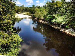
Metal railing, Okapilco Creek
EPA Clean Water Rule finalized
I still see EPA’s new Clean Water Rule
 as a good thing, since it protects drinking water,
paddling, and fishing, while opponents remain quite vague about
what might be wrong with it.
After last year’s comment period, U.S. EPA has posted a prepublication version of its final Clean Water Rule.
Katie Shepherd, L.A. Times, 27 May 2015, Under new EPA rule, Clean Water Act protections will cover all active tributaries, Continue reading
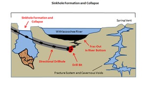
Sinkhole formation and collapse due to drilling under the Withlacoochee River
Drilling through fragile sinkhole-prone
 karst limestone under the Withlacoochee River (or the Suwannee River,
or the Santa Fe River): what could possibly go wrong?
Sabal Trail now proposes to move off of the Withlacoochee River in
Florida, but still plans to cross the Withlacoochee in Georgia,
and to cross the Suwannee and Santa Fe Rivers, all of which have
the same hydrogeology.
You can talk directly to Sabal Trail and FERC at the
Open House in Jasper, Florida, 5-7PM Tuesday 21 October 2014,
and you can join WWALS where the Alapaha River
disappears entirely into a sinkhole,
at the
Alapaha Sink, 2PM Sunday 26 October 2014.
Here are before and after diagrams by Continue reading
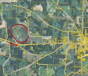
Bowen Mill Pond, Brooks County, Georgia
 For fishing in Brooks County, GA, try
Bowen Mill Pond, west of Quitman.
Heading west on US 84, turn right on Barwick Road between the Harveys and the Rite Aid, or right on Shiver Road.
Then turn left on Dry Lake Road, and eventually turn left on Bowen Mill Pond road.
You’ll see the pond on your right after a while.
Or, if you don’t mind dirt roads, turn off of US 84 onto Few Lane, immediately left onto Hassell Road, and when it curves to the right you’ll see the pond on your left.
Or keep going on US 84 until you see the tiny concrete marker Continue reading
Piscola Creek
 Running through Thomas and Brooks Counties, Georgia to the Withlacoochee River,
Piscola Creek is on the
USDA National Resources Conservation Service (NRCS)
National Water Quality Initiative (NWQI)
as two of the three Georgia Priority Watersheds,
all of which are in WWALS watersheds.
Upper Piscola Creek Watershed encompasses 25,936 acres of land in the southeast part of Thomas and western part of Brooks Counties in southwest Georgia. The land around the watershed is about 75 percent photo by Georgia NRCS crop, pasture, range and other associated agriculture use. About 20 percent of the watershed is forested. The other five percent is commercial or communities.
Middle Piscola Creek Watershed encompasses Continue reading
New Georgia law bans riding ATVs in riverbeds.

The measure should increase safety and reduce environmental damage.
House Bill 207, Continue reading
Alapaha River @ US 84: endpoint of Sunday’s WWALS Outing 24 August 2014
 Chris Graham took this picture a week ago of the Alapaha River at
US 84, where tomorrow’s WWALS Outing will end up.
Come join us on this gem of a blackwater rural river!
We’re boating the central area of the in-progress
Alapaha River Trail, tomorrow afternoon,
Sunday, August 24st 2014.
Meet up at 1:30 at Hotchkiss Crossing on the Lanier County side.
We will drop the boats off, drive the end point at US 84, on a public right of way, where the road is gravel.
Get on water at 2:00.
We will pass by the location for the new Lowndes County boat ramp and public access point. This is a relatively short paddle, about 1.27 miles, but it could take as long as 2 hours if the water level stays low.
This event is FREE! All we ask is that Continue reading
WWALS August Outing: Alapaha River @ Hotchkiss Crossing Lanier Side to 84 Bridge.
Update 23 Aug 2014: New picture and clarifications in new blog post.
On August 24, 2014 WWALS is having an outing on the Alapaha river. Are you up for a 1.27 mile paddle? Bring your canoe, kayak or small Jon boat to the Alapaha River.
Continue readingWWALS July 19 outing @ Banks lake
 WWALS is having an outing on July 19 @ Banks lake. So be there by 8:30am because we are putting in @ 9:00am. This is a beautiful scenic lake so don’t miss out. The location is @ 307 West Highway 122
Lakeland, Georgia 31635.
This event is FREE! All we ask is that you are a current member of WWALS Watershed Coalition. If not, its easy to join online today at /donations/.


