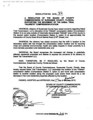
Category Archives: Law

WWALS in Waycross at EPA Seven Out Superfund meeting

It’s a serious situation in Waycross, with people getting sick and dying. The contamination, whatever it is, may have crossed into WWALS watersheds, as well. Good interactions between WWALS, Satilla Riverkeeper, and silentdisaster.org, plus EPA, GA EPD, and GA Health Dept.


Matthew J. Huyser, EPA (l. standing blue shirt), Jim Brown, GA EPD (c. standing white shirt), Ashby Nix, Satilla Riverkeeper (facing Brown, paper in hand), Joan Martin McNeal, silentdisaster.org (r. in group)

For details, see these posts on Lowndes Area Knowledge Exchange (LAKE): Continue reading

Entering the Floridan Aquifer Recharge zone –Kristofer Graham

Written as a newspaper letter to the editor and posted here with permission. -jsq

Dear Residents

Did you know Lanier County doesn’t have zoning laws. Which that mean they can development on wetlands and on our Floridan Aquifer Recharge zone and build resident houses, subdivided, commercial building etc., cut timber on wetlands, on our watersheds and a Natural Gas Company want to put a pipeline through on these precious lands they can. It will destroy the land environment like our Floridan Aquifer Recharge zone (aka our drinking water) and our wetlands and our watersheds. Because it not protected like it should.

Lanier County Groundwater Recharge Areas Well it time to protect it before it all destroy and gone. It is up to our local government to protect these precious lands and preserve it in the original state. Yes it’s time for our local government to do there job to protect it. So it can be there forever.

I notices they got those lands zone as Ag and V5 zone. Which those zone doesn’t protect it and in fact it can destroy those lands Eco system because they spray pesticide for there farm crops near the Floridan Aquifer Recharge zone and wetlands, our watersheds. It will Continue reading

Aquifer storage meeting in Newton, GA 7 November 2013

It looks like SB 213 is being resurrected after falling in the Georgia House in March. This GEFA ASR meeting is in Newton, which is not far west of Tifton. When will they be coming for the waters of the Little River, too?

Jim West in the Albany Herald 29 March 2013, Flint River bill fails in the House, quoted Gordon Rogers, Flint Riverkeeper, and then referred to Georgia Water Coalition:

One aspect of the bill river advocates found objectionable was the concept of “stream flow augmentation,” including aquifer storage and recovery, or ASR, which Coalition officials define as “the injection of ground water into the aquifer, which would be extracted later and sent downstream.” According to the Coalition, the process could cause irreversible contamination of the aquifer.

GEFA News 30 October 2013, Aquifer Storage Project Public Meeting Scheduled, Continue reading

JIA replies to WWALS about marsh and land

“There currently are no plans for more development on Jekyll Island” said JIA in a response to WWALS’ assertion that marsh is not land. So why does a map under consideration by JIA show all marsh as land at mean high tide? Could “currently” mean until the law gets changed? -jsq

Continue reading

Entering Floridan Aquifer Recharge Zone

Maybe we need signs like that around here to remind people that what goes into the ground comes out in our drinking water. For example, San Antonio has its Edwards Aquifer Protection Program. Maybe our local governments need to have Floridan Aquifer Protection Programs. Georgia state law seems to indicate they should.

GA Secretary of State has GA Code §391-3-16-.02 Criteria For Protection of Groundwater Recharge Areas. (more legible copy on GA EPD website),

Georgia's Groundwater Recharge Areas (1) Background. Variable levels of recharge area protection can be based upon the State’s hydrogeology (e.g., areas such as the Dougherty Plain where a major aquifer crops out would receive a relatively high degree of protection whereas other areas, such as the shale hills of northwest Georgia, would receive a lower degree of protection). Recharge area protection within the significant recharge areas would be further refined, based upon the local susceptibility or vulnerability to human induced pollution (e.g., high, medium, or low). The significant recharge areas have already been identified and mapped (about 22-23% of the State). Pollution susceptibility mapping is ongoing. Existing statutes are adequate for protecting the remaining recharge areas (about 77-78% of the State).

[…]

(2)(f)3. In the Coastal Plain, the significant recharge areas are Continue reading

JIA map shows all marsh as land at mean high tide –David Egan

Received Thursday on Marsh is not land, not here, not at Jekyll Island –WWALS Watershed Coalition -jsq

WWALS Watershed Coalition is on target with its analysis of the Jekyll 65-35 issue! Just a quick glance at the the 65-35 map under consideration by the JIA reveals all —- according to the JIA, ALL of Jekyll’s tidal marsh is above water, as in dry, at mean high tide, and is therefore part of the land area of Jekyll Islnsd subject to the 65-35 law. On-site conditions deny the accuracy of that map, for most of the marsh is actually under water (as in wet) at the time of high tide. The JIA’s map can be viewed at http://www.savejekyllisland.org/MPMOAAMHWPapJuly2013.html

-David Egan


SaveJekyllIsland.org wrote: Continue reading

Marsh is not land, not here, not at Jekyll Island –WWALS Watershed Coalition

Unanimously approved Wednesday by the WWALS board (PDF). JIA meets next Monday 15 July 2013.

From:
WWALS Watershed Coalition
3338 Country Club Road #L336
Valdosta, GA 31605
www.wwals.net
10 July 2013

To:
Governor Nathan Deal,
Attorney General Sam Olens,
the Jekyll Island Authority,
and the Georgia Legislature

Frog viewing swamp Here in central south Georgia our pocosin swamps and blackwater river flood plains are important for fishing, hunting, wildlife and ecological preservation as well as recreation and flood control. In our watersheds we have serious problems of flooding at least partly due to Continue reading

Ask Georgia Power to conserve our water –WWALS to GA PSC

Approved 12 June 2013 by unanimous vote of the WWALS board, Dave has mailed a signed copy to the Georgia Public Service Commission, and I will go read it to the PSC Tuesday morning at 10 AM 18 June 2013, at their hearing about

Docket 36498, Georgia Power Company’s 2013 Integrated Resource Plan and Application for Decertification of Various Units
and
Docket 36499, Application for the Certification of Amended Demand Side Management Plan

Y’all come! -jsq

From: WWALS Watershed Coalition, Inc.
3338 Country Club Road #L336
Valdosta, GA 31605
12 June 2013

To: Georgia
Public Service Commission

244 Washington Street, SW
Atlanta GA, 30334-9052

Dear Public Service Commissioners and Staff,

The recent rains have swollen our blackwater rivers, Withlacoochee, Willacoochee, Alapaha, and Little, under our longleaf pines and Spanish-moss-covered oaks, and filled up the tea-colored tannin waters in our frog-singing pocosin cypress swamps here in central South Georgia. But that was only a dent in our protracted drought that ranges from mild to extreme, with projections not much better.

We do not need more traditional big baseload power plants gulping down our river or aquifer water when solar and wind power use far less, and those renewables are now at grid parity with coal, natural gas, and nuclear.

Power plants are thirsty, as the Union of Concerned Scientists pointed out in a 2011 report, “Freshwater Use by U.S. Power Plants: Electricity’s Thirst for a Precious Resource”.

Much of the water used to cool power plants evaporates, and is Continue reading

Nonpoint Source Pollution biggest water quality problem –EPA

EPA found phosphorus and nitrogen from fertilizers, bacteria and other pollutants from urban runoff, plus mercury, in most U.S. rivers and streams. And they didn’t even mention low dissolved oxygen.

Ian Simpson wrote for Reuters, carried by NBC, EPA: More than half of U.S. rivers unsuitable for aquatic life,

Fifty-five percent of U.S. river and stream lengths were in poor condition for aquatic life, largely under threat from runoff contaminated by fertilizers, the U.S. Environmental Protection Agency said on Tuesday.

High levels of phosphorus and nitrogen, runoff from urban areas, shrinking ground cover and pollution from mercury and bacteria were putting the 1.2 million miles of streams and rivers surveyed under stress, the EPA said.

“This new science shows that America’s streams and rivers are under significant pressure,” Nancy Stone, acting administrator of the EPA’s Office of Water, said in a statement.

Twenty-one percent of the United States’ river and stream length was

Continue reading