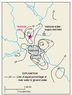
Interesting find by Heather in the State Wildlife Action Plan, July 31, 2015, Georgia Department of Natural Resources, Wildlife Resources Division, featuring the newly-scientifically-recognized Suwannee River alligator snapping turtle. Maybe we’ll see one on the WWALS outing this Sunday from Sasser Landing to Jennings Bluff, and you can preview some of the vegetation mentioned in Julie Bowland’s pictures.
Alapaha River Corridor
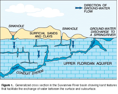
The Alapaha River is a nonalluvial (blackwater) river in the Gulf Coastal Plain of Georgia. The Alapaha River corridor includes significant upland habitats associated with sandhill environments. This system includes longleaf pine-scrub oak woodlands, old-growth dwarf pondcypress swamps, mesic hardwood bluffs, and depression ponds. High priority species associated with these habitats include striped newt, gopher frog, gopher tortoise, spotted turtle, eastern indigo snake, eastern diamondbacked rattlesnake, tiger salamander, silky camellia, and pondspice. The Alapaha River is inhabited by the Suwannee River alligator snapping turtle, a distinct, newly described species that is rarer in Georgia than the species found in other drainages. (Note: this conservation landscape spans the Southeastern Plains and Southern Coastal Plain.
Fortunately, the Alapaha River has no Continue reading