
How we manage water affects our water’s quality and quantity.
 WWALS Watershed Coalition is pleased to announce a Water
Conference where Gordon Rogers, Flint Riverkeeper will share information on hydrology of the South Georgia
region and Neill Herring, Environmental Lobbyist, will discuss upcoming legislation that can affect our watersheds and aquifer. The
conference will take place in Tifton on Saturday, August 24, 2013
from 9:00 am until noon at the NESPAL, University of Georgia, Tifton
Campus at 2360 Rainwater Road.
WWALS Watershed Coalition is pleased to announce a Water
Conference where Gordon Rogers, Flint Riverkeeper will share information on hydrology of the South Georgia
region and Neill Herring, Environmental Lobbyist, will discuss upcoming legislation that can affect our watersheds and aquifer. The
conference will take place in Tifton on Saturday, August 24, 2013
from 9:00 am until noon at the NESPAL, University of Georgia, Tifton
Campus at 2360 Rainwater Road.
JIA replies to WWALS about marsh and land
 “There currently are no plans for more development on Jekyll Island”
said JIA in a response to
WWALS’ assertion that marsh is not land.
So why does a map under consideration by JIA
show all marsh as land at mean high tide?
Could “currently” mean until the law gets changed? -jsq
“There currently are no plans for more development on Jekyll Island”
said JIA in a response to
WWALS’ assertion that marsh is not land.
So why does a map under consideration by JIA
show all marsh as land at mean high tide?
Could “currently” mean until the law gets changed? -jsq
Entering Floridan Aquifer Recharge Zone
Maybe we need signs like that around here to remind
people that what goes into the ground comes out in our
drinking water.
 For example,
San Antonio has its
Edwards Aquifer Protection Program.
Maybe our local governments need to have
Floridan Aquifer Protection Programs.
Georgia state law seems to indicate they should.
For example,
San Antonio has its
Edwards Aquifer Protection Program.
Maybe our local governments need to have
Floridan Aquifer Protection Programs.
Georgia state law seems to indicate they should.
GA Secretary of State has GA Code §391-3-16-.02 Criteria For Protection of Groundwater Recharge Areas. (more legible copy on GA EPD website),
(1) Background. Variable levels of recharge area protection can be based upon the State’s hydrogeology (e.g., areas such as the Dougherty Plain where a major aquifer crops out would receive a relatively high degree of protection whereas other areas, such as the shale hills of northwest Georgia, would receive a lower degree of protection). Recharge area protection within the significant recharge areas would be further refined, based upon the local susceptibility or vulnerability to human induced pollution (e.g., high, medium, or low). The significant recharge areas have already been identified and mapped (about 22-23% of the State). Pollution susceptibility mapping is ongoing. Existing statutes are adequate for protecting the remaining recharge areas (about 77-78% of the State).
[…]
(2)(f)3. In the Coastal Plain, the significant recharge areas are Continue reading
Paddle Georgia card from Georgia River Network
Very nice card from Georgia River Network about Paddle Georgia (facebook):

JIA map shows all marsh as land at mean high tide –David Egan
 Received Thursday on
Marsh is not land, not here, not at Jekyll Island –WWALS Watershed Coalition -jsq
Received Thursday on
Marsh is not land, not here, not at Jekyll Island –WWALS Watershed Coalition -jsq
WWALS Watershed Coalition is on target with its analysis of the Jekyll 65-35 issue! Just a quick glance at the the 65-35 map under consideration by the JIA reveals all —- according to the JIA, ALL of Jekyll’s tidal marsh is above water, as in dry, at mean high tide, and is therefore part of the land area of Jekyll Islnsd subject to the 65-35 law. On-site conditions deny the accuracy of that map, for most of the marsh is actually under water (as in wet) at the time of high tide. The JIA’s map can be viewed at http://www.savejekyllisland.org/MPMOAAMHWPapJuly2013.html
-David Egan
SaveJekyllIsland.org wrote: Continue reading
Paddle the Alapaha at US 82 2PM Saturday 27 July 2013
Join WWALS on our monthly outing, on the exotic Alapaha River:
Jungle-like in its remoteness and luxurious with exotic vegetation, the dark reddish-brown waters of the Alapaha wind through a swampy wonderland teeming with wildlife. — Alapaha River Paddling Guide, by Suzanne Welander
Yet it’s right here in Berrien County, Georgia, only an hour’s drive from Valdosta and less from Adel, Lakeland, Tifton, etc.
Meet at the intersection of Hwy 82 bridge and the Alapaha River, about 2 miles east of Alapaha, GA.

Park cars at the top near a derelict brick building (south of highway). There is a road down to the river but it is badly washed out so you probably want to take a look before you drive down.
We’re planning to paddle upstream a ways and then float back down.
Join the facebook event or just come paddle!
-jsq
Streamer on the Suwannee, Alapaha, and Withlacoochee Rivers: ten or more rivers and many creeks, lakes, swamps, and ponds
Update 3 March 2016: Suwannee River, ten rivers, and current location of USGS streamer.
The USGS Streamer interactive map shows all (well, most) tributaries of our two biggest WWALS rivers. Visitors sometimes refer to our “four rivers” since we only originally named four in our WWALS mission: Withlacoochee, Willacoochee, Alapaha, and Little. Yet we added the upper Suwannee, and there always were more than that: from one to ten rivers, depending on how you count them.
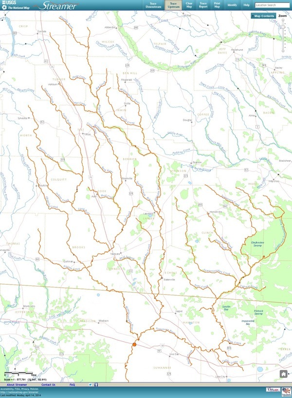
The Withlacoochee River tributary map here shows the New River south of Tifton joining the Withlacoochee between Nashville and Adel.
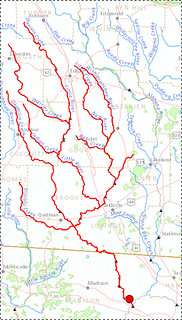
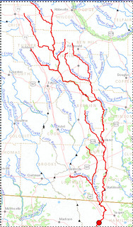
The New River is rather important, since it forms half of the boundary between Cook and Berrien Counties (the Withlacoochee River forms the other half): Continue reading
Request participation in watershed planning –WWALS to Corps
Unanimously approved 10 July 2013 by the WWALS board (PDF).

From:
WWALS Watershed Coalition
3338 Country Club Road #L336
Valdosta, GA 31605
wwalswatershed@gmail.com
www.wwals.net
10 July 2013
To:
Jeffrey S Morris
Savannah District
U.S. Army Corps of Engineers
100 W Oglethorpe Ave
Savannah, GA 31401
Jeffrey.S.Morris@usace.army.mil
Cc:
Mayor John Gayle
City of Valdosta
P.O. Box 1125
216 E. Central Ave.
Valdosta, GA 31603-1125
jgayle@valdostacity.comGreetings from the pocosin swamps and blackwater river floodplains of central south Georgia! Continue reading
Marsh is not land, not here, not at Jekyll Island –WWALS Watershed Coalition
Unanimously approved Wednesday by the WWALS board (PDF). JIA meets next Monday 15 July 2013.
WWALS Watershed Coalition
3338 Country Club Road #L336
Valdosta, GA 31605
www.wwals.net
10 July 2013
To:
Governor Nathan Deal,
Attorney General Sam Olens,
the Jekyll Island Authority,
and the Georgia Legislature
Here in central south Georgia our pocosin swamps and blackwater river flood plains are important for fishing, hunting, wildlife and ecological preservation as well as recreation and flood control. In our watersheds we have serious problems of flooding at least partly due to Continue reading
Solar passed GA PSC!
We (the people) won!

WWALS helped by writing a letter to GA PSC, reading it to them, and asking Commissioner Everett to vote for it. He did, and Georgia Power is now required to buy more than twice as much solar power. Details here.
-jsq