Lowndes County Chairman Bill Slaughter says the Naylor Boat Ramp is
on schedule for completion this fall, provided the Georgia Department
of Natural Resources returns the appropriate permits.
Lowndes County Chairman Bill Slaughter says the Naylor Boat Ramp is
on schedule for completion this fall, provided the Georgia Department
of Natural Resources returns the appropriate permits.
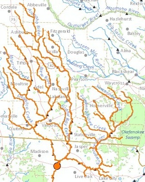
At last night’s Lowndes County Commission Regular Sesssion, WWALS president John S. Quarterman displayed the Alapaha River Water Trail brochures, pointing out the Naylor Boat Ramp on the map. He, ok, I, asked what was the status of that project that Lowndes County is building with SPLOST funds.
Nobody answered in the public meeting, but afterwards Continue reading