 Update from expedition leader Bret Wagenhorst:
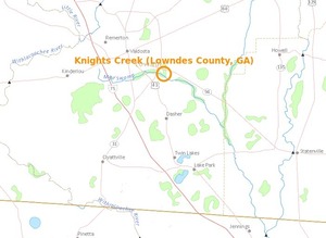
The current weather forecast for Saturday in Alapaha, GA is cloudy with 20% chance of thunderstorms. The water level on the Alapaha River at the Alapaha gauge
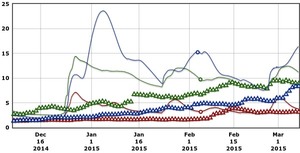
is 9.4 ft and appears to be plateauing. [The river has already been going down for a couple of days upstream at the Irwinville gauge. -jsq] Unless there are heavy rains in or north of Alapaha Friday, we should be able to proceed with our planned outing.
It should be a fast trip with the water this high, and with fast, high water comes increased risk, so this is probably not a great outing for a beginner.
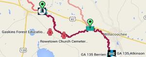
Know that the put in is actually Continue reading