
 Calls from Atlanta and from downstream in Florida about the
three Valdosta wastewater overflows in February prompted WWALS as the local watershed organization to contact
the City of Valdosta about organizing a presentation to the interested parties.
Valdosta presented less than two weeks later, and brought their entire hierarchy related to this issue, from the mayor on down. Plus Lowndes County, which isn’t even responsible for Valdosta’s wastewater, was represented by their Chairman and a Commissioner.
In
Valdosta’s slides and the LAKE videos of that meeting of Tuesday 17 March 2015,
you can see many questions were answered, but some are still open. Continue reading
Calls from Atlanta and from downstream in Florida about the
three Valdosta wastewater overflows in February prompted WWALS as the local watershed organization to contact
the City of Valdosta about organizing a presentation to the interested parties.
Valdosta presented less than two weeks later, and brought their entire hierarchy related to this issue, from the mayor on down. Plus Lowndes County, which isn’t even responsible for Valdosta’s wastewater, was represented by their Chairman and a Commissioner.
In
Valdosta’s slides and the LAKE videos of that meeting of Tuesday 17 March 2015,
you can see many questions were answered, but some are still open. Continue reading
Tag Archives: Alapaha River
Two Hamilton County businesses donate prizes for logo contest –Jasper News
 The local newspaper put a Hamilton County spin on the
Alapaha River Water Trail logo contest
PR, printed all three pictures, and ran it on most of full page.
The local newspaper put a Hamilton County spin on the
Alapaha River Water Trail logo contest
PR, printed all three pictures, and ran it on most of full page.
Valdosta CEO also carried the PR 18 March 2015.
WWALS thanks all the logo prize donors, all the sponsors of the Alapaha River Water Trail, the teachers, and especially the student contestants.
-jsq
How many Valdosta overflows into Knights Creek and the Alapaha River watershed?
And how many into Dukes Bay Canal, which also flows into Mud Creek,
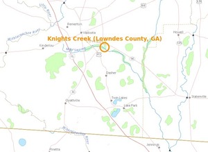 to the Alapahoochee River, to the Alapaha River, to the Suwannee River, to the Gulf?
It’s great the Valdosta City Council Thursday will
consider more fixes to wastewater problems in the Withlacoochee River watershed.
But what is Valdosta doing about problems in the Alapaha River watershed?
to the Alapahoochee River, to the Alapaha River, to the Suwannee River, to the Gulf?
It’s great the Valdosta City Council Thursday will
consider more fixes to wastewater problems in the Withlacoochee River watershed.
But what is Valdosta doing about problems in the Alapaha River watershed?
The three Valdosta overflows into the Alapaha River watershed in February 2015 weren’t the first. How many others have there been?
This report is from 19 March 2014: Continue reading
South Georgia talent won the Alapaha River Water Trail Logo Contest
Update 2015-03-20: Two Hamilton County businesses donate prizes for logo contest –Jasper News.
FOR IMMEDIATE RELEASE
South Georgia talent won the Alapaha River Water Trail Logo Contest
Alapaha, Georgia, March 16th 2015 — South Georgia’s got talent! Winners from Tift County High School and Lanier County High School got cash and other prizes for their logo submissions at the Alapaha River Water Trail conference Saturday.
![[Maya Turner with her First Place logo]](https://www.wwals.net/pictures/2015-03-14--logo-winners/winner-and-logo.jpg)
Maya Turner with her First Place logo in Logo Winners, by Deanna Mericle, 14 March 2015
- First Place winner, Maya Turner, senior at Tift County High School, took home $100 and two admission tickets to Wild Adventures Theme Park, Valdosta for her winning logo design in the WWALS Watershed Coalition’s Alapaha River Water Trail logo contest on Saturday March 14, 2015 at the Continue reading
Alapaha River precipitation and levels
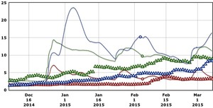 Rainfall can be quite different in Statenville on the Alapaha River as shown here than in Valdosta on the Withlacoochee River.
But remember half of Valdosta drains into the Alapaha River watershed.
Rainfall can be quite different in Statenville on the Alapaha River as shown here than in Valdosta on the Withlacoochee River.
But remember half of Valdosta drains into the Alapaha River watershed.
Here are rainfall and water level graphs from the three USGS Alapaha River gauges in Georgia. The Florida gauge is shown separately, because it use a different base level, and precipitation doesn’t seem to be available from Florida gauges. See also always-current graphs of all the levels. Continue reading
Summary of Statenville to Sasser Landing WWALS Outing –Bret Wagenhorst 2015-02-15
Saw: tupelo, cypress, maple, river birch, pine, live oak, titi, mayhaw, native blueberries, palmetto; only maple in bloom. Not much wildlife.
 River: several small streams entered river through breaks in the bank, winding course, couple of bluffs and some exposed karst
Comments: a good level to run this section, saw 2 other canoes with a family of campers, and a fisherman in a john boat skinning a catfish, 2 rope swings, the side trip up the Alapahoochee River to the waterfall just up from the take out was worth the effort.
Pictures: see separate post by Bret Wagenhorst. And pictures by John S. Quarterman.
Ten of us met at 12 noon Sunday afternoon, February 15th 2015, continuing our exploration of the Alapaha River Water Trail, as announced.
The shuttle took Continue reading
Statenville to Sasser Landing WWALS Outing pictures by Bret Wagenhorst 2015-02-15
 Here’s the
outing announcement,
here is Bret’s summary of the outing, and below are Bret’s pictures. Continue reading
Here’s the
outing announcement,
here is Bret’s summary of the outing, and below are Bret’s pictures. Continue reading
Valdosta spilled into Alapaha as well as Withlacoochee watersheds in February
Spilling sewage into the Withlacoochee River apparently wasn’t enough
 for Valdosta: in February it also spilled three times into the
Alapaha River watershed.
At least once this was due to rains directly on Valdosta,
for which
the
levee proposed by the Army Corps of Engineers on Sugar Creek
at the Withlacoochee River wouldn’t help.
It’s time for Valdosta to move along with fixing its wastewater problems.
More transparency from Valdosta would also help.
And I, for one, would like to see that promised Corps flooding study
of the entire Suwannee River Basin.
for Valdosta: in February it also spilled three times into the
Alapaha River watershed.
At least once this was due to rains directly on Valdosta,
for which
the
levee proposed by the Army Corps of Engineers on Sugar Creek
at the Withlacoochee River wouldn’t help.
It’s time for Valdosta to move along with fixing its wastewater problems.
More transparency from Valdosta would also help.
And I, for one, would like to see that promised Corps flooding study
of the entire Suwannee River Basin.
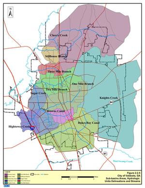
In three different reports in February, Valdosta mentioned sewage overflows into either Knights Creek or Dukes Bay Canal, without mentioning that those flow into Mud Swamp Creek, which joins with Grand Bay Creek to form the Alapahoochee River, which joins the Alapaha River, which flows into the Suwannee River. The Florida Department of Health apparently didn’t know that, since it didn’t mention the Alapaha River in its advisories for counties downstream. But Valdosta should know, according to its own SWMP Update Phase 1 Final Report, Section 2 Methodology, 2011-01-14, that about half of Valdosta is drained by Knights Creek and Dukes Bay Canal: Continue reading
Easy Outing on the Alapaha River at GA 135, 2015-03-14
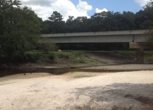 4PM Saturday March 14th
at GA 135 in Berrien County near Willacoochee:
paddle upstream on the Alapaha River and float back.
The river will be higher than pictured here.
All are welcome, boats are available! facebook event.
4PM Saturday March 14th
at GA 135 in Berrien County near Willacoochee:
paddle upstream on the Alapaha River and float back.
The river will be higher than pictured here.
All are welcome, boats are available! facebook event.
This is immediately following the WWALS Alapaha River Water Trail Conference being held at the Gaskins Forestry Education Center near Alapaha, GA from 1-4 p.m. Come see the high school student logo contest winners for the Water Trail, and then paddle on the Trail!
This event is FREE! All we ask is Continue reading
Updated WWALS Brochure with Alapaha River Water Trail
Plus Chris Mericle has joined the WWALS Board, the board now meets quarterly, and much of the work is done through Committees, but the big addition is a map and access points for the Alapaha River Water Trail. Here’s PDF for printing, and images are below, all thanks to Karan Rawlins.
Update: 2015-06-08: See the new Alapaha River Water Trail Brochure, Map, and Card all in one!

