Tag Archives: Cherry Creek Sink

WWALS to Valdosta: please deny deannexation of Cherry Creek Mitigation Bank 2021-08-05

Update 2021-08-31: Denied: Deannexation of Cherry Creek Mitigation Bank @ VCC 2021-08-05.

August 5, 2021 (see also PDF)

To: Matt Martin, Valdosta City Planner, mlmartin@valdostacity.com

Re: Please deny VA-2021-16 Deannexation Request by Uvalde Land Company

Dear Planner Martin,

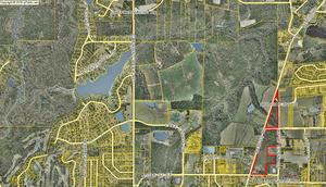
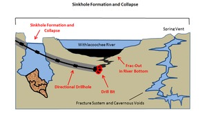
WWALS Watershed Coalition, Inc. asks the Valdosta Mayor and Council to deny deannexation of half of the Cherry Creek Mitigation Bank (CCMB) in VA-2021-16 at its meeting this Thursday, August 5, 2021. As you know, the Greater Lowndes Planning Commission (GLPC) already voted 6-3 to recommend against deannexation.
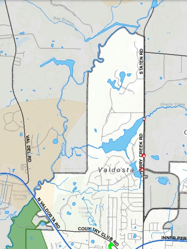
[Location, Sinkholes]
Location, Sinkholes

Given the lack of any good reasons by the applicant for deannexation of that 310 acres of Withlacoochee River floodplain around Cherry Creek, let me remind everyone of some reasons not to deannex.

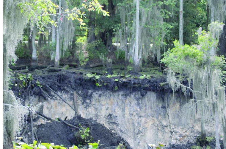
The CCMB is directly across the Withlacoochee River from Shadrick Sink. Valdosta already had to sink its water wells on Guest Road twice as deep because of river water going into Shadrick Sink, then through ground water several miles east to those wells. The choice was to pay for much more expensive methods to deal with tannic acid and biological components of the river water, or dig the wells deeper. This is literally a textbook case: Continue reading

Staten Road to Langdale Park, Withlacoochee River, 2018-03-03

A leisurely five mile paddle in about two and a half hours through a surprisingly wild section of the Withlacoochee River, much of it actually inside Valdosta, the biggest city in the Suwannee River Basin, on the Withlacoochee and Little River Water Trail (WLRWT).

When: 9 AM, Saturday, March 3, 2018

Put In: Staten Road Landing, 4556 Staten Road, Valdosta, GA 31605, Lowndes County, GA. 7.1 miles north of downtown Valdosta. Beware: it’s a long rough dirt road access, then a scramble down the riverbank.

GPS: 30.9328, -83.28227

Take Out: Langdale Park Boat Ramp, 3781 N. Valdosta Rd., Valdosta, GA 31602, Lowndes County, GA.

Free: This outing is Free! And we recommend you support the work of WWALS by becoming a WWALS member today!

Event: facebook, meetup

VALORGIS, Route
Map: VALORGIS. White is Valdosta inside grey city limits, yellow is recharge zones for the Floridan Aquifer, green is Langdale Park.

We start in Lowndes County, cross over the county’s expanded sewer and water lines at Bay Branch (those lines head for Stafford-Wright Road). Then the City of Valdosta is on our left briefly before back to county both sides, and Sermons Branch (is that its real name?). Into a Floridan Aquifer recharge zone, passing on our right the Shadrick Sink, notorious for Continue reading

Another sinkhole near where Sabal Trail proposes to gouge its pipeline

What if a sinkhole develops years later under the proposed pipeline in south Georgia or north Florida, and Sabal Trail declares force majeure and doesn’t pay, like FGT did in Louisiana in 2013?

Numerous news stories are linked in the LAKE blog post, but let’s pick just one.

Winnie Wright, WCTV, 5 August 2015, 150-Foot Sinkhole Opens in Lowndes County Residential Area, Continue reading

AJC video: Proposed Natural Gas Pipeline Through 9 Counties

Most people are opposed to the Sabal Trail pipeline, as the Colquitt County landowner says. Drilling in our fragile karst limestone “could potentially carry any contamination down into our groundwater source”, as VSU Geology Prof. Don Thieme says. Why should we risk that for profit for companies from somewhere else and no benefit for here?

Atlanta Journal Constitution, Proposed Natural Gas Pipeline Through 9 Counties, Continue reading

Vallotton Farms upstream from Withlacoochee Sinks

Update 2017-09-13: The Lowndes County Commissioners surprisingly agreed to rezone “backwards” to Estate A gricultural (E-A) at their Regular Session of 14 April 2015.

300x172 Withlacoochee Sinks downstream from Cherry Creek and Vallotton Farms, in Vallotton Farms, by John S. Quarterman, for WWALS.net, 30 March 2015 A historic dairy farm wants to go back to the most agricultural zoning, upstream on Cherry Creek from the Cherry Creek Sink that leaks into the Floridan Aquifer. Vallotton Farms (both the part outlined in red that appears to be the subject of the rezoning and the bigger part west of Bemiss Road) includes quite a bit of Cherry Creek itself. Agriculture is probably better than other likely uses in such a location. Continue reading

Sinkhole formation and collapse due to drilling under the Withlacoochee River

Drilling through fragile sinkhole-prone karst limestone under the Withlacoochee River (or the Suwannee River, or the Santa Fe River): what could possibly go wrong? Sabal Trail now proposes to move off of the Withlacoochee River in Florida, but still plans to cross the Withlacoochee in Georgia, and to cross the Suwannee and Santa Fe Rivers, all of which have the same hydrogeology. You can talk directly to Sabal Trail and FERC at the Open House in Jasper, Florida, 5-7PM Tuesday 21 October 2014, and you can join WWALS where the Alapaha River disappears entirely into a sinkhole, at the Alapaha Sink, 2PM Sunday 26 October 2014.

Here are before and after diagrams by Continue reading