Tag Archives: CR 141

US 41 closed between Lake Park, GA, and Jennings, FL, near Alapahoochee River 2023-02-10

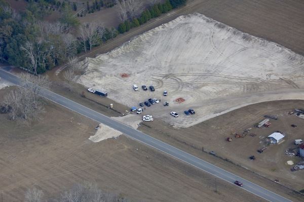
Judging by the continuing downpour, I’d guess US 41 will stay closed through today at least.

[Map, US 41 Road closed, 2023-02-11]
Map, US 41 Road closed, 2023-02-11

The GDOT press release is pretty vague about where the water is across the road, so there are some guesses below, after the press release.

Maybe somebody around Lake Park or Jennings can send some pictures.

GDOT Press Alert, Friday, February 10, 2023 Lowndes and Echols Counties: State Route 7 in Lakepark , GA to Jennings, FL is closed due to water over the roadway, Continue reading

WWALS Summary of FDEP chemical and biological tracers, Withlacoochee and Suwannee Rivers 2020-08-05

Here are the chemical tracer and DNA marker test results by the Florida Department of Environmental Protection (FDEP) that WWALS has frequently mentioned, for example in Current Situation of Water Quality Testing, Suwannee River Basin 2020-08-02.

Below, please also find a summary of those results by WWALS Science Committee Chair Dr. Thomas Potter.

[Human and Ruminant DNA markers]
Human and Ruminant DNA markers

Thanks to Katrina Yancey of FDEP for sending the data, and for acknowledging that FDEP has no objection to WWALS publishing it. I asked FDEP for whatever they wanted to include, and this is what they sent:

“Thank you for asking, we recently set up our new site so it may be helpful to state that more information may be found at DEP’s webpage for the Suwannee River Basin Sampling Locations (https://floridadep.gov/dear/watershed-monitoring-section/content/suwannee-river-basin-sampling-locations).”

The actual data is on the WWALS website.

WWALS Summary of FDEP chemical and biological tracer measurements
on Withlacoochee and Suwannee River samples

Dr. Thomas Potter, WWALS Science Committee Chair

After Continue reading

Mostly clean in Georgia, not in Florida, Withlacoochee River 2020-01-15

The Mayor’s Paddle is still a go for tomorrow (Saturday), according to results from Lowndes County and WWALS for Wednesday, January 15, 2020.

[Valdosta caution sign gone]
Valdosta caution sign gone at Troupville Boat Ramp

From way up at US 41 (North Valdosta Road), all the way to Saturday’s takeout, Spook Bridge (thanks, Langdale Company), WWALS got results well within state water quality standards.

[2020-01-15 GA green, FL red]
2020-01-15 GA green, FL red
The entire spreadsheet is on the WWALS website.

For Knights Ferry and Nankin Boat Ramps, Lowndes County got Continue reading

Recent water quality test results, Withlacoochee and Suwannee Rivers 2020-01-11

Update 2020-01-15: Georgia Department of Health can’t or won’t do as much as FDOH 2020-01-07.

The Withlacoochee River still looks clean for the Mayor’s Paddle from Troupville Boat Ramp to Spook Bridge this Saturday.

SRWMD actually tested upstream from there last Wednesday at GA 133. SRWMD’s and FDEP’s test at US 84, Knights Ferry, and State Line Boat Ramp (GA 31) were also clean that day, and the next day FDOH tested at GA 31 and still found it clean. Suzy Hall tested for WWALS this Saturday, and found Knights Ferry, Nankin, and State Line Boat Ramps clean.

[Most recent contamination]
Most recent contamination

The not so good news is that the most recent FDOH tests in Florida, Continue reading

Valdosta sewage from Sugar Creek to Florida 2019-01-01 2020-01-01

Update 2020-01-03 Valdosta Sewage Public Meeting, Valdosta City Hall Annex, 2020-01-08.

You can see Valdosta’s sewage going down the Withlacoochee River as the high red numbers in these composite tables WWALS has cobbled together from various data sources (all acknowledged below).

Early on, the sewage apparently mostly sat in Sugar Creek downstream from the spill site, due to low water and no rain.

[Early (12/10-12/18)]
Early (12/10-12/18)

Most of the Georgia numbers in above table are from Valdosta Utilities data. The ones marked with a W are WWALS data using the Georgia Adopt-a-Stream 3M Petrifilms method.

Fecal coliform numbers started dropping in Sugar Creek at Gornto Road on December 14, and were much more acceptable by December 15 and 16th. Where did the sewage go? Continue reading

Gibson Park to CR 141, Suwannee River, 2017-08-13

A pleasant just over five mile Sunday paddle on the Suwannee River as we take a short upstream paddle to the Alapaha River Rise. Then enjoy the river’s current downstream past the Alapaha River Confluence (there may be water in the Alapaha) to County Road 141 Ramp. There are a couple of springs along the way. Those still feeling energetic can paddle a few more thousand feet down to the Sabal Trail crossing and back to CR 141.


Suwannee River beach, 2015-08-15, 30.4193954, -83.1344223

Bring the usual personal flotation device, water, snacks, first aid kit, and gloves, trash bag, and gripper because every WWALS outing is also a cleanup. If you do not have a boat, ask us, or contact one of the many outfitters.

When: 9AM, Sunday, August 13, 2017

Put-In: Gibson Park Ramp, SRWT MILE 135.4, 6844 SW CR 751, Jasper, FL 32052, From Jasper, travel southwest on SW CR 249 to SW CR 751; turn left and boat ramp is on the right in Gibson Park.

GPS: Continue reading

CR 141 Sabal Trail Troy Access, Hamilton County, FL 2017-01-14

Are those two sinkholes at Sabal Trail’s Troy Access off CR 141 in Hamilton County, Florida, on the way to to under the Suwannee River? Only three Hamilton County Sheriff’s deputies was light law enforcement by Saturday’s protest day standards. What about those other sinkholes just outside the pipeline easement?

NE to CR 141 Sabal Trail entrance with 3 Hamilton Co. Sheriff, 30.4164450, -83.1765850

NE to CR 141 Sabal Trail entrance with 3 Hamilton Co. Sheriff,

SE to CR 141 Sabal Trail Troy Access, 30.4171760, -83.1768130

Continue reading

Sabal Trail Hamilton County Suwannee River HDD

Movie: Generator at drill site (1.5M) The pipe to go under the Suwannee RIver is laid out, welded, and has pressure test fittings at the Hamilton County side of the Suwannee River, but the drill site itself has nothing but a generator. So it looks like they’re drilling under from the Suwannee County side Here are some pictures and videos taken in Hamilton County near CR 141. Sabal Trail didn’t like that.

Pressure fitting on pipe

This is the site at 30.410381, -83.165874 that you see in the foreground in an aerial picture in a previous post.

Here’s a playlist of WWALS videos, and there are more pictures below. Continue reading

#NoDAPL #NoSabalTrail @ Suwannee River State Park 2016-09-13

Update 2016-12-09: Here are directions to Suwannee River Campsites at 30.414, -83.159167. Facing the boat ramp, up to your right you’ll see a trail head. Follow the trail into the woods along the river bank. The river bends left, then right. Shortly after the right bend is the crossing, at 30.407379, -83.156494. Sabal Trail has marked its path in the woods; stay off of their easement but follow it until you come to a field where you should be able to see the HDD site. Send back lots of pictures. For maps and aerial pictures, see Sabal Trail maps digitized. Much more information here. And you may want to ask the CEO of college-savings mutual fund Virginia529 why her company is the biggest mutual fund stockholder in the stranded investment of Spectra Energy.

Yes, Sabal Trail wants to cross the Suwannee River IN Suwannee River State Park.


How many pipelines do we want? Continue reading

Protest Sabal Trail at Suwannee River Crossing 2016-09-13

Update 2016-09-24: Video from the river and pictures from the bluff.

You are invited to protest Sabal Trail and the Dakota Access Pipeline this Tuesday 5:30 PM! News media are invited. Walk with signs along the bluff to the proposed Sabal Trail Suwannee River HDD crossing, or paddle downstream and back.

Gathering at Sabal Trail proposed pipeline crossing 30.4071464, -83.1569366 We aim to get pictures and video of people on the bluff, beach, and river at the same time demanding the Army Corps re-evaluate its permit for Sabal Trail just like its permit for the Dakota Access Pipeline (DAPL). Both pipelines should be canceled: keep it in the ground!

This WWALS Outing is part of the #NoDAPL Day of Action — Tuesday Sep. 13, tying the Dakota Access oil Pipeline to the Sabal Trail fracked methane pipeline through their ownership by the same companies. This outing is also a followup to Continue reading