Tag Archives: Florida

Rivers go underground at the Cody Scarp

The Alapaha River goes underground because the underlying karst limestone rises in what’s called the Cody Scarp, which runs across north Florida. Other rivers that go underground there include the Little Alapaha River and the Santa Fe River. The Withlacoochee River does not go underground, but it does sprout Madison Blue Spring.


Source: Bulletin of the Geological Society of America, vol. 123, no. 3-4, p. 457.

Here’s a cutaway diagram of how all that works underground: Continue reading

Avoid karst and water and demonstrate need for the Sabal Trail pipelne –Dougherty County Commission to FERC

A county commission is representing its people and the waters of Georgia in a resolution Dougherty County sent to FERC which says in part:

300x391 Resolution page 2, in Resolution No. 14-019 pipeline and compressor station, by Dougherty County Commission, for SpectraBusters.org, 5 November 2014 SECTION II Thus, we are in opposition to the construction of the proposed pipeline in Dougherty County and request that FERC give serious consideration and analysis to alternative routes (1) that avoid unstable geologic areas such as karst and sink-hole prone areas, (2) that minimize impacts to drinking water and agricultural water supplies, (3) that minimize impacts to wildlife habitat, forest, wetlands, streams and rivers and (4) that do not compromise socio-economic and cultural issues.

Continue reading

Alapaha River water levels

Update 2025-09-21: Graphs from water.noaa.gov.

300x655 Example 2014-11-03, in Alapaha River Water Levels, by John S. Quarterman, for WWALS.net, 3 November 2014 Update 2016-12-23: graphs from water.weather.gov.

Update 2016-05-31: See sea level gage reports.

Update 2015-04-28: Added flood stages and tentative highest safe and lowest boatable water levels, both above the charts for each gauge and in a summary table. If you have data, please let us know.

Here are water level gauges for the Alapaha River in Georgia and Florida, north to south. The graphs should show the current levels at this time, in feet, plus for most of the gauges a bar graph of selected historic levels.

This is a draft of a concept for use with the Alapaha River Water Trail. See also Alapaha River Rainy Season.

It is also a companion to the similar set of graphs for the Withlacoochee and Little Rivers.

See below for the current Alapaha River water level graphs. Continue reading

Dust Storm on Lakeland Sands land in Hamilton County, FL

300x225 Dust right up to dirt road, in Dust Storm on Lakeland Sands land in Hamilton County, FL, by John S. Quarterman, for WWALS.net, 25 March 2014 Received yesterday. -jsq

These pictures are of a dust storm that occurred earlier this year. The dust is from Bill Gates’ farms. Look closely, there is a power transmission tower in the picture. Continue reading

Hamilton County, FL and Bill Gates

300x265 Parcel 5069-010 aerial, in Lakeland Sands and Bill Gates in Hamilton County, FL, by John S. Quarterman, for WWALS.net, 25 October 2014 Two dozen agricultural parcels owned by a shell of a shell of a shell company investing for Bill Gates in Hamilton County, Florida. Two parcels are in the Withlacoochee River watershed and within the blast radius of the original path of the Sabal Trail fracked methane pipeline.

The Hamilton County, Florida, Property Appraiser shows these results for a search for Lakeland Sands: Continue reading

Dead River Sink, Alapaha River, WWALS Outing, 2PM 26 Oct 2014

This Sunday afternoon, Oct 26th at 2PM: where the Dead River meets the Alapaha River and goes underground at the Dead River Sink, aka the Alapaha Sink. 300x149 Dead River Sink, in Jennings Bluff Tract, by SRWMD, 24 October 2014 Park on SRWMD’s Jennings Bluff Tract and walk in with WWALS to see what Samuel Taylor Coleridge dreamed as “Where Alph, the sacred river, ran Through caverns measureless to man Down to a sunless sea.” No boat required: this is a walking outing.

It’s an adventure, as Deanna Mericle reported recently:

300x225 Red with human for scale, in Alapaha Sink, by Chris Mericle, 16 September 2014 …the hike to the sink does have some steep parts, especially if you go the scenic route, which I recommend. The area around the sink itself is kind of steep with slick mud/clay. So wear good shoes for hiking. There were only a few Mosquitos. The area is beautiful and worth the effort.

This event is FREE! All we ask is Continue reading

Bill Gates gobbling up Georgia farmland, too

300x567 Aerial of Southwest Echols County, in Cottonwood Ag Management in SW Echols County, by John S. Quarterman, 22 October 2014 Update 2015-01-11: People seem confused as to what Bill Gates is doing. However, since he announced in 2012 he was going to “fix” agriculture in conjunction with Monsanto and Syngenta, and he’s buying up hundreds and thousands of contiguous acres at a time, it seems pretty clear he’s promoting corporate pesticided GMO agriculture.

Update 2015-01-13: More Gates purchases in more counties.

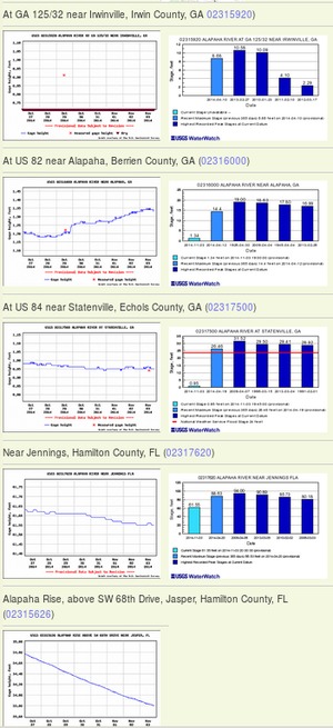
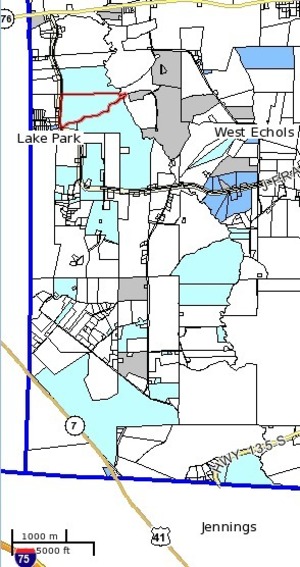
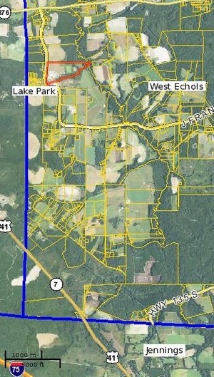
Add Echols County and Lowndes County, Georgia, including much of Lake Park, and Hamilton and Madison Counties, Florida, in addition to what Amber Vann wrote in the VDT and other papers today 22 October 2014, Bill Gates gobbling up Florida farmland

LIVE OAK, Fla. — The investment company that manages the wealth of the world’s richest man, Bill Gates, has been acquiring gobs of farmland in north Florida the past two years, real estate records show.

Lakeland Sands Florida, a subsidiary of Cascade Investments LLC, which oversees the Gates fortune, recently bought more than 4,500 acres in Suwanee County near McAlpin, an unincorporated community just south of here.

300x529 Southwest Echols County, in Cottonwood Ag Management in SW Echols County, by John S. Quarterman, 22 October 2014 Meanwhile, Bill Gates owns Cascade Investment LLC, which owns Los Arboles LLC, which changed its name to Cottonwood Ag Management LLC, which bought land in Echols County on the Alapahoochee River, a year after Bill Gates said he was going to fix agriculture in conjunction with Monsanto and Syngenta.

Cottonwood Ag Management LLC does not own any land in Lowndes, Hamilton, or Madison Counties. But Lakeland Sands does: Continue reading

GWC DD#9: Sabal Trail pipeline threatens Withlacoochee River and Floridan Aquifer

300x388 DD#9 2014 Page 1 of 2, in GWC DD#9: Sabal Trail pipeline threatens Withlacoochee River and Floridan Aquifer, by Georgia Water Coalition, for WWALS.net, 22 October 2014 Here is the WWALS item #9 in the Georgia Water Coalition Dirty Dozen 2014; I added the links and the illustrations. -jsq

2014’s
Worst Offenses Against 
GEORGIA’S WATER

WITHLACOOCHEE RIVER & FLORIDAN AQUIFER

Gas Pipeline Threatens Southwest Georgia Water, Way of Life

INTRODUCTION:

Southwest Georgians are fighting an invader—one every bit

as worrisome as the boll weevil that destroyed cotton harvests in the 1900s, except this one takes farmers’ land as well as crops. Continue reading

Sinkhole formation and collapse due to drilling under the Withlacoochee River

Drilling through fragile sinkhole-prone karst limestone under the Withlacoochee River (or the Suwannee River, or the Santa Fe River): what could possibly go wrong? Sabal Trail now proposes to move off of the Withlacoochee River in Florida, but still plans to cross the Withlacoochee in Georgia, and to cross the Suwannee and Santa Fe Rivers, all of which have the same hydrogeology. You can talk directly to Sabal Trail and FERC at the Open House in Jasper, Florida, 5-7PM Tuesday 21 October 2014, and you can join WWALS where the Alapaha River disappears entirely into a sinkhole, at the Alapaha Sink, 2PM Sunday 26 October 2014.

Here are before and after diagrams by Continue reading

Sabal Trail Withlacoochee River Alternative and Jasper Open House 21 Oct 2014

Due to fine work by WWALS members Chris and Deanna Mericle in Hamilton County, Florida, 300x391 Withlacoochee River Crossing Route Alternative, Hamilton and Suwannee Counties, Florida (bare), in Sabal Trail Notice of EIS Intent, by John S. Quarterman, for SpectraBusters.org, 15 October 2014 Sabal Trail proposes to move its fracked methane pipeline off of the Withlacoochee River in Florida, and invites the public to an Open House in Jasper, FL Tuesday October 21st about that and other matters. We can ask them to move it off the Withlacoochee River in Georgia, too. And it’s still possible to file ecomments with FERC, and to contact your local, state, and national elected and appointed officials.

In FERC’s 15 October 2014 Sabal Trail Notice of EIS Intent and Route Alternatives, Continue reading