Tag Archives: Quitman

All 527 Sabal Trail alignment maps from April 2016

Courtesy of Lowndes Area Knowledge Exchange, you can now see small, big, huge, and PDF versions of all 527 alignment maps Sabal Trail filed with FERC in April 2016: follow this link.

[STA. 11870+00 TO STA. 11923+00, (UT OKAPILCO CREEK), 11881+44 CL SPAIN ROAD, 11871+70 CL GOLDING ROAD, BROOKS COUNTY, GEORGIA]

Having these maps online like this makes it easier to see what’s in them. Sabal Trail told FERC Okapilco Creek was not among the streams for which the Georgia legislature denied river-drilling easements (and for which Sabal Trail got the easements later anyway by suing the state in county Superior Courts). Yet Sabal Trail’s alignment maps from April 2016 seem to say that fracked methane pipeline crosses Okapilco Creek a couple of times in Brooks County, Georgia.

Here’s one of those times, in which the road names don’t match Continue reading

Sabal Trail preparing to drill under Withlacoochee River in Georgia 2016-10-05

Update 2016-10-23: Aerial photography and videos: US 84 HDD Withlacoochee River Sabal Trail 2016-10-22: what is that yellow thing in the river, and is that round thing you’ve marked a sinkhole?

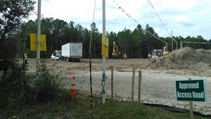
Approved Access Road, CAUTION, No Trespassing, 30.7873010, -83.4457610 Where would you guess Southeast Directional Drilling is based? Nope: Arizona. And the TRW truck has a Texas license plate. So much for local jobs where Sabal Trail is preparing to drill under the Withlacoochee River in Lowndes and Brooks Counties, Georgia, between Valdosta and Quitman.

Here is a playlist of WWALS videos, followed by a google map, and still pictures: Continue reading

Truck surveying at Withlacoochee River Lowndes County side

Follow this link for videos, more pictures, and a google map.

HDD equipment truck at Withlacoochee River Lowndes County Sabal Trail site

Follow this link for videos, more pictures, and a google map.

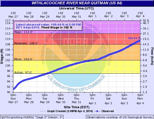
Flooding at Valdosta, 2016-04-04

Wondering why Valdosta is having an overflow problem? It was rain on Valdosta, and north of Valdosta.

US 84, Withlacoochee River

Not so much northwest on the Little River, nor even west on Okapilco Creek: Continue reading

Blue Spring and McIntyre Spring, Withlacoochee River, Brooks County, GA, 1903-11

Update: 4610-foot explored cavern under McIntyre Spring.

Blue Spring between Quitman and Valdosta has been known since the settling of Brooks County, when it was used as a reference point in building roads starting in 1859. Here’s an early 20th century report, with a much later picture postcard (probably not the same building) and location map.

A Preliminary Report on the Underground Waters of Georgia, by S. W. McCallie, State Geologist, Continue reading

Sea level gage reports: all USGS gages in WWALS territory in Georgia

All the Suwannee River Basin USGS gages in Georgia just got a new flood level reporting system (except they missed one). Locator Map: Central South Georgia USGS Gages They’ve added a level measurement from sea level, probably not coincidentally about the same as the Florida gages added a level measurement from dry riverbed, so both Georgia and Florida gages now have both measurements. This actually does not affect the WWALS level charts for the Withlacoochee and Little River Water Trail nor for the Alapaha River Water Trail, because those continue to display water levels from dry riverbed. To see this change at all, you have to drill down to the USGS detail pages, for example on the Withlacoochee River at Skipper Bridge Road in Georgia, or near Pinetta, Florida.

National Weather Service Weather Forecast Office, Tallahassee, FL, unknown date, Suwannee River Basin Datum Changes in South Central Georgia,

Starting on October 14, 2015, the National Weather Service in Tallahassee and Jacksonville will make adjustments to the reporting method for water level in the Suwannee River System. This includes river gages in the following rivers or creeks: Continue reading

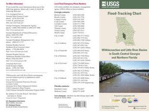
USGS Flood-Tracking Chart for Withlacoochee and Little River Basins

An interesting flyer pointed out by Emily Davenport, Storm Water Utilities Director, City of Valdosta. It has many useful contacts on the front, and tips on the back (don’t walk or drive through flood waters) but the most useful part is inside, where the flood-tracking chart is, in Flood-tracking chart for the Withlacoochee and Little River Basins in south-central Georgia and northern Florida, 2014, by Gotvald, Anthony J.; McCallum, Brian E.; Painter, Jaime A., USGS General Information Product: 155.

Here are the gages mentioned in the chart, with links to the live USGS FloodTracking pages, Continue reading