Tag Archives: Suwannee River

Southern Cross Dairy (Suwannee Farms) liquidation and permit renewal 2019-11-25

Today I got an automated notice from FDEP about a wastewater permit for Suwannee Farms, and a WWALS member sent a picture of this auction sign saying “HUGE PRODUCE & ROW CROP FARM COMPLETE LIQUIDATION” next to a bigger sign saying Suwannee Farms. This is in Suwannee County near the Suwannee River.

[HUGE PRODUCE & ROW CROP FARM COMPLETE LIQUIDATION]

I called DeMottAuction.com and asked if the land was also for sale. They said they weren’t selling the land, only equipment. Which of course doesn’t mean that the land is not for sale; only that Continue reading

Drone aerials of titanium mine site near Okefenokee Swamp 2019-11-23

Yesterday someone sent me drone pictures of the titanium mine site near the Okefenokee Swamp. They were taken from above GA 94, looking northwest.

You can still can comment against the proposed mine to the U.S. Army Corps of Engineers.

[Closeup 2019-11-23]
Closeup 2019-11-23

For comparison, here is an aerial Wayne Morgan took for WWALS on October 5, 2019, on a Southwings flight Continue reading

Okefenokee flyaround –Wayne Morgan 2019-10-05

The cause of this flight was the titanium mine Twin Pines Minerals wants to put near the southeast corner of the Okefenokee Swamp. We documented they have heavy equipment on that site now:


      031Equipment Twin Pines Minerals mine site T Model Road
031Equipment Twin Pines Minerals mine site T Model Road

The Georgia Water Coalition Dirty Dozen, used one of these aerial pictures taken by Wayne Morgan for WWALS on a Southwings flight for Suwannee Riverkeeper, pilot Allen Nodorft, October 5, 2019.

The mine site is less than three miles from the Okefenokee National Wildlife Refuge, and about the same distance from the Cherokee of Georgia Tribal Grounds:


      029Cherokee of Georgia Tribal Grounds
029Cherokee of Georgia Tribal Grounds

For more about why that mine is a bad idea, see the Waterkeepers Florida resolulution against the mine.

For how bad it can get, see Continue reading

Pothole Spring, Suwannee River, Dixie County, Florida 2019-11-13

SRWMD checked on Pothole Spring, found it normal, and asks everyone to send in pictures of how they have seen it. This is on the Suwannee River in Dixie County, Florida.

[Looking out to the Suwannee River]
Looking out to the Suwannee River
Photo by Marc Minno, Suwannee River Water Management District on November 13, 2019.

Received November 13, 2019 from Marc Minno, Water Resource Coordinator, Suwannee River Water Management District (SRWMD):

I visited Pothole Spring today with colleagues to see if there is some problem. The spring is located on the west side of the Suwannee River at the southern end of the Suwannee River Water Management District’s Booker Springs Tract in Dixie County, Florida. Following is a description from Springs of Florida, Continue reading

Okefenokee Swamp on GWC Dirty Dozen because Titanium Mine 2019-11-14

Announced yesterday to press across Georgia and beyond, the titanium mine near Georgia and Florida’s Okefenokee Swamp proposed by Twin Pines Minerals of Alabama made the Georgia Water Coalition Dirty Dozen (see also PDF).

You can still file a comment with the Army Corps and GA-EPD asking them to reject the mine or at least require an Environmental Impact Statement. Convenience for miners is no excuse to risk the fishing, boating, and birding in the swamp and hunting and forestry nearby.

[Closeup]
Closeup of TPM equipment on mine site from GA 94 westbound.
Photo: John S. Quarterman for WWALS, November 14, 2019

2019’s
Worst Offenses Against
GEORGIA’S WATER
OKEFENOKEE SWAMP, ST. MARYS AND SUWANNEE RIVERS

Proposed 2,400-Acre Titanium Mine Threatens Signature Landscape of Georgia

INTRODUCTION:

Twenty years ago when chemical giant DuPont proposed mining titanium dioxide ore near the Okefenokee Swamp, opposition to the plan was so strong— Continue reading

Troupville River Camp, center of Little and Withlacoochee River Water Trail 2019-10-31

Here’s the narrative we sent Thursday in the WWALS pre-application to the Georgia Outdoor Stewardship Program (GOSP) (many more details are on the WWALS website):


A Troupville River Camp will attract paddling and fishing enthusiasts of all ages. The property is located at the Confluence of the Little River with the Withlacoochee River, off of I-75 and GA 133 just west of Valdosta, the biggest city in the Suwannee River Basin. Proposed amenities include air-conditioned bathrooms, hot and cold running water, five screened sleeping platforms, picnic tables and benches, outdoor fire pits, and paddle boat racks for canoes, kayaks, and paddle boards, with river access near the Confluence.

[Paddlers departing in the Confluence Viewscape]
Paddlers departing in the Confluence Viewscape

The location is historic, where Troupville was the former Lowndes County seat before Valdosta, from 1833 to 1860. The property has been privately owned since then and is now available for purchase for this purpose.


Map of Troupville, GA adapted from C.S. Morgan, in Ray City History Blog, 9 February 2014, Map of Old Troupville, GA with Notes on the Residents.
jsq note: the scale of the streets on this map is too large; few of them extended onto the subject property;
thanks for clarification by Wiregrass Region Digital History Project (WRDHP).

The Land Between the Rivers has Continue reading

Cindy Leighton with Paddle Georgia on the Withlacoochee River –Herald-Leader 2019-08-28

The story begins, “When Cindy Leighton set out on the 2019 Paddle Georgia trip on June 15, putting her kayak into the waters of the Little River, she was taking part in something Paddle Georgia hasn’t done before — heading to Florida.”

WWALS member Cindy Leighton sent us images of this story by Sherri Butler, Herald-Leader, Fitzgerald, Ben Hill County, Georgia, Section B Feature Front, August 28, 2019, Paddle Georgia crosses the line for a river journey spotlighting lue springs of Florida, which goes beyond Paddle Georgia into Water Trails and River Camps.

[Front page]
Front page

On the feature front page, Continue reading

Waterkeepers Florida passes resolution against titanium mine application near Okefenokee Swamp

Waterkeepers Florida asks the Army Corps to require Twin Pines Minerals to supply all the information missing from its application for a titanium mine near the Okefenokee Swamp, to prepare a full Environmental Impact Statement (EIS), to hold Public Hearings, including in Florida, and “to answer how the Corps has or will determine that the Applicant’s proposed mine would not adversely affect the Okefenokee Swamp, the St. Marys River, the Suwannee River, the Floridan Aquifer, or the State of Florida.”

You can also still comment to the Army Corps.

[TPM Equipment closeup, Wayne Morgan]
TPM Equipment closeup Photo: Wayne Morgan for Suwannee Riverkeeper on Southwings flight, pilot Allen Nodorft, 2019-10-05.

Continue reading

Floridan Aquifer withdrawals affect the Okefenokee Swamp, so how could TPM’s withdrawals not? 1995-04-11

Water withdrawals from the Floridan Aquifer affect water levels and quality in the Okefenokee Swamp, a pair of researchers concluded 24 years before Twin Pines Minerals of Alabama proposed to withdraw 2.4 4.32 million gallons per day from the Aquifer for a titanium mine within a few miles of the Swamp:

Abstract. A rapid response is observed between water level fluctuations in the Okefenokee Swamp and water levels in the underlying Floridan Aquifer. A lag of approximately one month is common, and a hydraulic diffusivity of 3.83 x 10⁻³ m2 s-1 best matches the calculated aquifer response to the swamp water level perturbations. The magnitude of leakage between the swamp and the aquifer is uncertain because of a lack of knowledge about the specific storage coefficient in the aquitard separating the swamp and the aquifer which has not been explicitly measured. An intermediate value of specific storage within the likely range of values results in a down- ward vertical flow of 1.2 meters of water per year. This induced recharge can significantly alter the natural water balance within the swamp. Such a large loss of water from the swamp may be responsible for observed pH and water level changes, and increased beavy metal accumulations in aquatic organisms in the swamp.

We cited that study[5] on page 4 of the Suwannee Riverkeeper comments to USACE about TPM, just after noting Twin Pines application to withdraw 4.32 million gallons per day (mgd) of Floridan Aquifer water much closer to the Swamp than any other permitted withdrawal. TPM’s own hydrology study in that withdrawal application shows a cone of depression in the Floridan Aquifer extending under the Swamp:

[Figure 8. Drawdown 2930 days]
Figure 8. Drawdown 2930 days

How could that not affect Swamp water levels and content?

As pointed out to the Corps by Okefenokee Swamp Park (OSP), any change to the water level in the Swamp would Continue reading

Okefenokee Camping and Paddle, Griffis Fish Camp 2019-12-06-08

Update 2021-06-24: Suwannee River Sill, Griffis Fish Camp 2019-12-08
Kayak Raffle Drawing 2019-12-07

Come camp at Griffis Fish Camp Friday, paddle 14 miles to Fargo Saturday, camp again, and paddle 7.5 miles Sunday from Stephen C. Foster State Park in the Okefenokee Swamp, back to camp, all on the blackwater Suwannee River. And see the drawing for the kayak raffle for a Perception Swifty Deluxe 95 Angler Sit Inside Kayak!

We will deliver the kayak, Drawing Raffle Ticket Winner
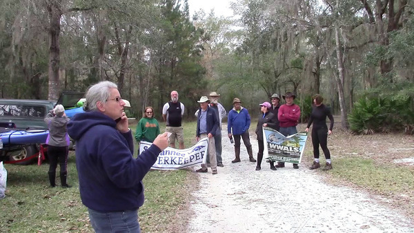
Photo: Gretchen Quarterman for WWALS. WWALS Kayak Raffle Drawing at Griffis Fish Camp, 2018-12-09.

When: 4:00 PM Friday, December 6, 2019, camp at Griffis Fish Camp
9:00 AM Saturday, December 7, 2019, paddle down to Fargo Ramp
8:30 AM Sunday, December 8, 2019, paddle from Stephen C. Foster State Park Ramp back to camp

Where: Griffis Fish Camp, 10333 Ga Highway 177 Fargo, Georgia 31631, in Clinch County.
From Fargo, travel south on US 441 to CR 177; turn left and travel 10 miles northeast; Griffis Fish Camp is on left.

GPS: 30.728505, -82.4436

[Sandy Suwannee downstream from Tatum Creek by John S. Quarterman, 12:04:13, 30.7161810, -82.5134767]
Sandy Suwannee downstream from Tatum Creek by John S. Quarterman for WWALS, on Southwings flight, pilot Allen Nodorft, 2019-10-05 12:04:13, 30.7161810, -82.5134767

Bring: You must wear a PFD and have a tow rope. Also boat, paddles, food, drinking water, warm clothes, and first aid kit. Also trash pickers and trash bags: every WWALS outing is also a cleanup.

Free: This outing is free to WWALS members, and $10 (ten dollars) for non-members for each day. So if you paddle Saturday and Sunday and you are not a member, that will be $20. Becoming a member is only $25…. We recommend you support the work of WWALS by becoming a WWALS member today!

Park fees: Griffis Fish Camp charges for camping or river put-in.
There is a $5 park entry fee at Stephen C. Foster State Park.

Camping: If you want to camp at the State Park, reserve well in advance through ReserveAmerica.
If you don’t want to camp, there are cabins at the State Park, and the nearby Eco-Lodge has heated hotel rooms.

Event: facebook, meetup Continue reading