Tag Archives: Suwannee River

Paddle Georgia discovers the Withlacoochee River

Would you like to paddle the Withlacoochee and Suwannee Rivers for a week in June 2019 with 300 of your closest friends? Our rivers topped Paddle Georgia’s poll of six destinations. Joe Cook, Mr. Paddle Georgia, called me back in July about this possibility. That’s why on July 5, 2018, I blogged A week on the Withlacoochee River in June?

Shoals on the Withlacoochee River
Paddle Georgia discovering the Withlacoochee River has rapids.

It turns out there was a story in the Continue reading

Rivers bigger and more important that previously thought 2018-06-28

Rivers and streams cover more of the earth’s surface than previously thought, and likely interchange more CO2 and other gases with the atmosphere than previously thought. WWALS Science Committee Chair Tom Potter found this paper.

George H. Allen and Tamlin M. Pavelsky, Science, 28 Jun 2018, DOI: 10.1126/science.aat0636 Global extent of rivers and streams,

Abstract

The turbulent surfaces of rivers and streams are natural hotspots of biogeochemical exchange with the atmosphere. At the global scale, the total river-atmosphere flux of trace gasses such as CO2 depends on the proportion of Earth’s surface that is covered by the fluvial network, yet the total surface area of rivers and streams is poorly constrained. We used a global database of planform river hydromorphology and a statistical approach to show that global river and stream surface area at mean annual discharge is 773,000 ± 79,000 km2 (0.58 ± 0.06%) of Earth’s non-glaciated land surface, an area 44 ± 15% larger than previous spatial estimates. We found that rivers and streams likely play a greater role in controlling land-atmosphere fluxes than currently represented in global carbon budgets.
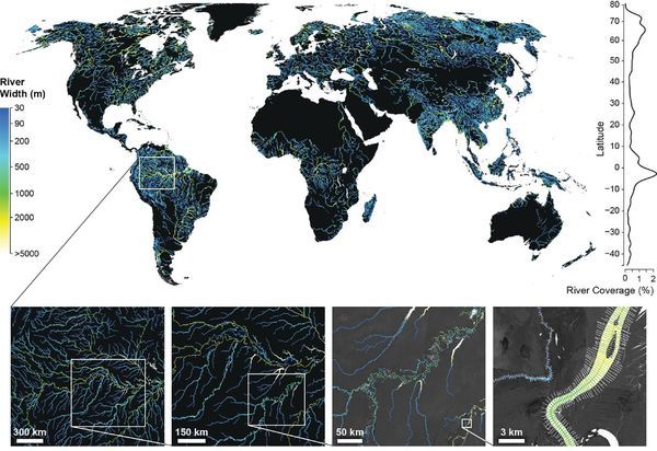
Fig. 1. Global River Widths from Landsat (GRWL) Database, Figure
Fig. 1. The Global River Widths from Landsat (GRWL) Database contains more than 58 million measurements of planform river geometry. The line plot on the right shows observed river coverage as a percentage of land area by latitude, and the bottom insets show GRWL at increasing zoom. The rightmost inset shows GRWL orthogonals over which river width was calculated, with only every eighth orthogonal shown for clarity.

You can see the lower Suwannee River in the above figure.

The authors zoom in on the Amazon River Basin in Brazil, but those last two zooms could easily be Continue reading

Bob’s River Place variances 2018-08-14

The Bob’s River Place agenda item on the SRWMD agenda for August 14, 2018 turns out to be the latest in year-long series. Every time I’ve stopped by it’s been closed, so I have no dog in this fight. I’m merely presenting what I’ve dug up in a few minutes by following leads backwards. This agenda-and-minute trail is probably incomplete, but what I’ve found tells a tale about SRWMD granting permits, then receiving citizen complaints including about safety. After which it seems SRWMD discovered numerous structures and other features that had been operational for years, yet had not been permitted.

[Slip and slide ramp removed from permit application 2/5/2013 yet constructed 4/7/2017]
Slip and slide ramp removed from permit application 2/5/2013 yet constructed 4/7/2017
PDF

FAR 2018-01-17

Starting with the earliest mention I’ve found in this series and going forwards, Florida Administrative Register, Volume 44, Number 11, January 17, 2018, Continue reading

Packet, SRWMD Board, 2018-08-14

The many interesting items on the agenda for next Tuesday morning’s SRWMD board meeting in Live Oak, include a springs campaign discussion, water withdrawals, creek clearing in Bradford County, and the latest in a long-running series about Bob’s River Place in Dixie County.

When: 9AM Tuesday, August 14, 2018

Where: 9225 CR 49, Live Oak, FL 32060

See also the other post about Bob’s River Place.

 -jsq, John S. Quarterman, Suwannee RIVERKEEPER®

You can join this fun and work by becoming a WWALS member today!

Video: Jay Jourden singing Save Our Suwannee at SuwRK Songwriting Contest

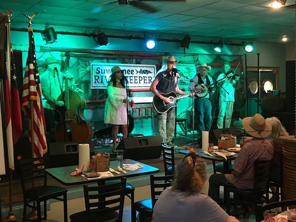
Jay Jourden sang “Save Our Suwannee” and won a prize, at the First Annual Suwannee Riverkeeper Songwriting Contest, Saturday, June 23, 2018, at the Salty Snapper, Valdosta, GA.

Jay Jourden
Jay Jourden (photo by Bret Wagenhorst)

If there’s any song other than Stephen Foster’s that anybody knows about the Suwannee, it’s usually this one, which is a call to action:

The water table’s going down, cricks are running dry….
They say we need more power, there’s more rain in the sky….

But where’s that water going, and who says it’s so..??..
Somebody’s got the answers that we’d all like to know..!!..

Here’s the video: Continue reading

Suwannee tributaries flooding 2018-08-07

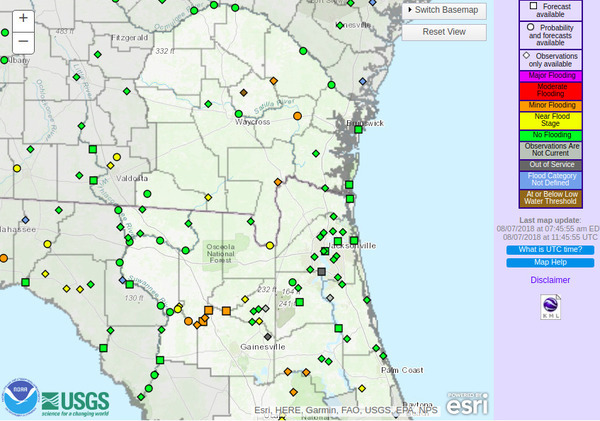
Once again, as during Hurricane Irma, recent rains are causing flooding on Suwannee River tributaries.

Suwannee River Basin, Map

The Withlacoochee River at Skipper Bridge and at US 41 (North Valdosta Road) is in Near Flood Stage, as is the Suwannee River at Fargo, and the New River near Lake Butler.

Already in Minor Flooding are Continue reading

Dave Pharr singing Care For the Waters @ Suwannee Riverkeeper Songwriting Contest 2018-06-23

David B. Pharr sang this Traditional Folk song, “Care For the Waters,” at the First Annual Suwannee Riverkeeper Songwriting Contest, Saturday, June 23, 2018, at the Salty Snapper, Valdosta, GA.

David B. Pharr

As he sang about the Suwannee and the other rivers: “And you may cross my bridges, But you’ll never get over me.”

Here’s the video: Continue reading

FPL Echo River Solar Energy Facility, Suwannee County, FL

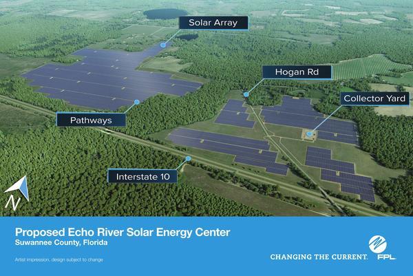
Let me echo a local resident: “I’m just saying where … is Echo River?” FPL’s new solar farm in Suwannee County just north of I-10 east of Live Oak actually straddles Rocky Creek, which runs north across I-10, through this FPL solar farm, and on into the Suwannee River just downstream of I-75.

Artist impression by FPL, Maps

Jamie Wachter, Suwannee Democrat, and Valdosta Daily Times, 18 May 2018, FPL plans for solar farm off I-10,

LIVE OAK, Fla. — An 800-acre property that once grew timber alongside Interstate 10 in northeastern Suwannee County may soon sprout solar panels.

This 2016 aerial map from the Suwannee County Property Appraiser does show Continue reading

World’s largest phosphate company after 20 years loses to DeSoto County, FL

The bigger they are, the harder they fall. Mosaic Co., market cap $11.5 billion, just lost to DeSoto County, Florida, annual budget $84.3 million. Maybe this will help Bradford County to do the right thing about phosphate mines.

Craig Pittman, Tampa Bay Times, 26 July 2018, Mosaic spent 20 years planning new phosphate mine. DeSoto County has rejected it,

Mosaic Co., the world’s largest phosphate company, has spent two decades lining up a new mine in DeSoto County as part of a broader effort to move its operations south.

W across PCS Phosphate Mine,
Photo: Jim Tatum on Southwings flight for WWALS, 2016-10-22: W across PCS Phosphate Mine, 30.4429360, -82.7851800

But DeSoto County commissioners last week slammed the door in the company’s face, voting 4-1 against rezoning 18,000 acres from agricultural to mining.

A major concern: Continue reading

BMAP petition letters including from a Florida state springs expert

Unlike FDEP’s BMAP plans, “When a new building code is final in Florida, [Rusty] Payton [CEO, Florida Home Builders Association] said, “there’s always six months between the final rule and the date the rule takes effect.” Because of his organization’s petition for more time to file a protest, none of Florida’s new Basin Management Action Plans (BMAPs) have gone into effect yet, which gives spring and river advocates (and FDEP) more time to try to fix them.

Dinah Voyles Pulver, Daily Commercial, 30 July 2018, Groups protest new Florida springs action plans,

A sweeping effort to adopt action plans to improve water quality in 13 springs systems across the state is on hold after a dozen groups and individuals asked to intervene with the Florida Department of Environmental Protection, including one of the department’s own springs experts.

Thomas Greenhalgh, a hydrogeologist with the department’s Florida Geological Survey, is one of two people who asked for an administrative hearing on one of the 13 “basin management action plans” signed by Noah Valenstein in late June.

Suiting up, Thomas Greenhalgh
Thomas Greenhalgh suiting up before releasing dye into the Dead River of the Alapaha River to go into the Dead River Sink, 2016-06-22, Picture by John S. Quarterman for WWALS.

“There are many claims and statements in the BMAP that I believe are inaccurate and unsubstantiated,” wrote Greenhalgh in seeking a state hearing on the plan for the Suwannee River, where he owns property.

He’s not alone.

In addition Continue reading