Tag Archives: WWALS

Video: River etiquette and invitation to the Alapaha River Water Trail Conference and outing

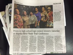
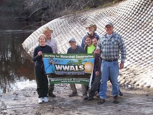
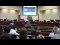
WWALS Treasurer Gretchen Quarterman invited everyone to discuss river etiquette and private property and to see the prizes awarded to the high school logo contest winners at the Alapaha River Water Trail Conference tomorrow, and to go on the river outing afterwards.

She spoke in Citizens Wishing to Be Heard at the Regular Session, Lowndes County Commission (LCC), Valdosta, Lowndes County, Georgia, 10 March 2015.

Here’s the video:

Continue reading

Alapaha River precipitation and levels

300x153 90 Days Levels Graph, in Alapaha River Levels and Precipitation, by USGS, for WWALS.net, 7 March 2015 Rainfall can be quite different in Statenville on the Alapaha River as shown here than in Valdosta on the Withlacoochee River. But remember half of Valdosta drains into the Alapaha River watershed.

Here are rainfall and water level graphs from the three USGS Alapaha River gauges in Georgia. The Florida gauge is shown separately, because it use a different base level, and precipitation doesn’t seem to be available from Florida gauges. See also always-current graphs of all the levels. Continue reading

Withlacoochee River levels follow rainfall

300x153 7 days Precipitation Graph, in Withlacoochee River Gauges, by NWS, for WWALS.net, 7 March 2015 Plus early March rains really were directly on Valdosta, even more than in Valdosta’s third wastewater spill of February, yet river levels rose most downstream.

Here are 90-day graphs of precipitation (in inches) and river levels (in feet) at the three Georgia Withlacoochee River gauges, from USGS. Also note river levels can continue dropping even while some new rain falls. Continue reading

Spring Flood Potential Outlook for Withlacoochee River by NWS

There is potential for “a high impact basin-wide flood event this spring should heavier than normal rainfall occur” in the Withlacoochee Basin.

300x233 Vdsg1 Hg Skipper Bridge, in Withlacoochee River Gauges, by NWS, for WWALS.net, 7 March 2015 National Weather Service Tallahasee, FL 240 PM EST THU MAR 5 2015, Spring Flood Potential Outlook for Southeast Alabama, Southwest and South Central Georgia, and the Florida Panhandle and Big Bend,
Above normal potential for river flooding this Spring,
Existing Conditions.

In the Withlacoochee, Suwannee Basin…

Continue reading

Summary of Statenville to Sasser Landing WWALS Outing –Bret Wagenhorst 2015-02-15

Saw: tupelo, cypress, maple, river birch, pine, live oak, titi, mayhaw, native blueberries, palmetto; only maple in bloom. Not much wildlife.

300x225 WWALS At Sasser Landing, in Sasser deanna, by Deanna Mericle, for WWALS.net, 15 February 2015 River: several small streams entered river through breaks in the bank, winding course, couple of bluffs and some exposed karst

Comments: a good level to run this section, saw 2 other canoes with a family of campers, and a fisherman in a john boat skinning a catfish, 2 rope swings, the side trip up the Alapahoochee River to the waterfall just up from the take out was worth the effort.

Pictures: see separate post by Bret Wagenhorst. And pictures by John S. Quarterman.

Ten of us met at 12 noon Sunday afternoon, February 15th 2015, continuing our exploration of the Alapaha River Water Trail, as announced.

The shuttle took Continue reading

Riverkeepers v. Palmetto Pipeline

Kinder Morgan wants to run a 360-mile Palmetto pipeline from South Carolina through Georgia to Florida, but has found organized opposition in Push Back the Pipeline:

We oppose the Palmetto Project. Our coalition includes Savannah Riverkeeper, Altamaha Riverkeeper, Ogeechee Riverkeeper, Satilla Riverkeeper, St. Johns Riverkeeper, One Hundred Miles, and Environment Georgia. Kinder Morgan would build 360 miles of new pipeline across land and rivers in SC and on GA’s coast, a risk we just can’t take. Building another pipeline is a risk to Continue reading

Hamilton County resolution to ban fracking in Florida

Chris Mericle reported yesterday:

The Hamilton Co. BOCC voted today to pass Resolution 2015-2, a resolution to support SB-166 and HB-169 to ban Fracking in the State of Florida.

For background, see previous post. Here is the text of the resolution:

RESOLUTION 2015-02

300x400 WHEREAS, in Resolution to ban fracking in Florida, by Hamilton County BOCC, for WWALS.net, 3 March 2015 A RESOLUTION OF THE BOARD OF COUNTY COMMISSIONERS OF HAMILTON COUNTY, FLORIDA, SUPPORTING PROPOSED LEGISLATION (SB 166 and HB 169) PROVIDING A STATEWIDE BAN ON HYDRAULIC FRACTURING, ACID FRACTURING, AND WELL STIMULATION PERFORMED FOR THE PURPOSES OF EXPLORATION OR PRODUCTION OF OIL OR NATURAL GAS IN THE STATE OF FLORIDA; PROVIDING AN EFFECTIVE DATE.

WHEREAS, well stimulation treatments may involve the use of hundreds of chemicals, some of which are known to be carcinogenic or could otherwise be harmful to human health; and Continue reading

Valdosta spilled into Alapaha as well as Withlacoochee watersheds in February

Spilling sewage into the Withlacoochee River apparently wasn’t enough 300x388 Figure 2.2.5. Sub-basins Areas, in Section 2 Methodology, by City of Valdosta, for WWALS.net, 14 January 2011 for Valdosta: in February it also spilled three times into the Alapaha River watershed. At least once this was due to rains directly on Valdosta, for which the levee proposed by the Army Corps of Engineers on Sugar Creek at the Withlacoochee River wouldn’t help. It’s time for Valdosta to move along with fixing its wastewater problems. More transparency from Valdosta would also help. And I, for one, would like to see that promised Corps flooding study of the entire Suwannee River Basin.

In three different reports in February, Valdosta mentioned sewage overflows into either Knights Creek or Dukes Bay Canal, without mentioning that those flow into Mud Swamp Creek, which joins with Grand Bay Creek to form the Alapahoochee River, which joins the Alapaha River, which flows into the Suwannee River. The Florida Department of Health apparently didn’t know that, since it didn’t mention the Alapaha River in its advisories for counties downstream. But Valdosta should know, according to its own SWMP Update Phase 1 Final Report, Section 2 Methodology, 2011-01-14, that about half of Valdosta is drained by Knights Creek and Dukes Bay Canal: Continue reading

Regional aquifers crossed, according to Sabal Trail

300x388 Figure 2.2-1, in Regional Aquifers Crossed by the Sabal Trail Project, by John S. Quarterman, for SpectraBusters.org, 20 February 2015 Sabal Trail seems to have a very constrained idea of the Floridan Aquifer that doesn’t include areas in for example Colquitt, Brooks, and Lowndes County that USGS says are in the Floridan Aquifer. But at least Sabal Trail is admitting its fracked methane pipeline would cross numerous aquifer systems.

Filed with FERC 2015-02-20 as Accession Number: 20150220-5131, “Sabal Trail Transmission, LLC submits supplemental information on adopted alternatives and information on other reroutes and modifications under CP15-17.” PDF. Continue reading