Category Archives: creeks

Okapilco Creek flooding @ GA 122 2017-01-23

Narrow Bridge 30.9955325, -83.6041529 
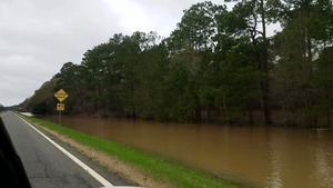
Half a mile wide: Okapilco Creek one week ago on GA 122 between Barney and Pavo, Georgia.

Usually you have to peer down into the woods to see if you can see any water in the creek. After the recent storms, you could see water beside the highway half a mile before you got to the creek bridge.

WWALS video: Continue reading

Tornado crosses Sabal Trail unfinished pipeline last night: time to report violations 2017-01-20

It’s time to photograph and report all potential Sabal Trail violations after last night’s storm. Pipeline construction should stop until damage can be independently assessed. I-75 is shut down, and so should Sabal Trail be.

Thats not daylight The sky was lit by lightning all night as a tornado killed two people in Brooks County and more in Cook County, Georgia. In between is Sabal Trail’s pipeline path across Okapilco Creek. I-75 is closed. What did that tornado do to the unfinished pipeline? What will all this water and wind do to all the Sabal Trail pipe exposed on top of the ground? What about that frac-out and sinkhole at Sabal Trail’s Withlacoochee River drilling only a short way downstream? What about Sabal Trail’s pipe going into that now probably waterlogged ream under the Suwannee River, or the Withlacoochee River South? What about Continue reading

Tornado crosses Sabal Trail unfinished pipeline: more corrosion? 2017-01-20

It’s time to photograph and report all potential Sabal Trail violations after last night’s storm. Pipeline construction should stop until damage can be independently assessed. I-75 is shut down, and so should Sabal Trail be.

Thats not daylight The sky was lit by lightning all night as a tornado killed two people in Brooks County and more in Cook County, Georgia. In between is Sabal Trail’s pipeline path across Okapilco Creek. I-75 is closed. What did that tornado do to the unfinished pipeline? What will all this water and wind do to all the Sabal Trail pipe exposed on top of the ground? What about that frac-out and sinkhole at Sabal Trail’s Withlacoochee River drilling only a short way downstream? What about Sabal Trail’s pipe going into that now probably waterlogged ream under the Suwannee River, or the Withlacoochee River South? What about Continue reading

Sabal Trail in Lowndes County, GA 2016-12-12

Sabal Trail’s 100-foot gouge makes the old pipeline right of way look like nothing, across Lowndes County, Georgia; pictures by John S. Quarterman for WWALS on 12 December 2016, with videos and a google map.

Troy Access signs start on Nankin Road shortly after you come up from Florida.

Rocky Ford Road is the most obvious pipeline crossing. You can see all the way to it from Barrett Coody Road. Continue reading

Sabal Trail now drilling under Suwannee and 5 other rivers and creeks 2017-01-03

Sabal Trail is drilling pilot holes under the Tallapoosa River in Alabama and the Withlacoochee (south) River in Florida, according to its latest biweekly report filed today. HDD Construction (1 of 2) It’s already reaming a bigger hole under the Suwannee River in Florida and the Chattahoochee River at the Alabama-Georgia border, as well under Hillabee Creek and State Highway 22 in Alabama. Hillabee Creek seems to keep taking longer.

In Georgia, drilling is completed under Earth Dam, the Flint River, the Ochlockonee River, and the Withlacoochee River, and in Florida under the Santa Fe River, Shingle Creek, and Dyer Blvd.

Drilling has not started under Continue reading

What WWALS Does: watershed advocacy from outings and water trails to wastewater and pipelines

Water trails, wastewater, corporate agriculture, solar power, fracking, and pipelines: WWALS works with many issues in many ways, as part of our advocacy for conservation and stewardship through education, awareness, environmental monitoring and activities such as our monthly paddle outings. McIntyre Spring snorkel 30.6416626, -83.3660889

Here’s an introduction to WWALS for the many new members and even more people following WWALS on facebook and twitter.

WWALS Watershed Coalition, or WWALS for short, is an IRS 501(c)(3) nonprofit corporation about everything related to water in the watersheds Continue reading

Bevel Creek, not Beaty Creek, on Williams Road off Loch Laurel, Lowndes County, Georgia

Mystery finally solved of where is the road over what creek does Lowndes County Georgia want to replace a bridge?

Loch Laurel Road to Williams Road --Google Maps Item 6.b. Replacement of Beatty Creek Bridge on Williams Road, for yesterday morning’s Lowndes County Commission Work Session: where is this for the $634,800 low bid from Southern Concrete Construction of Albany, GA? There are two Williams Roads in Lowndes County and no Beaty Creek. In the north end of the county Cat Creek has a tributary Beatty Mill Creek, with a Williams Road running near it between Upper New Bethel Road and Beatty Mill Creek Road. But according to all the maps I can find, Williams Road does not cross Beatty Mill Creek.

So what exactly is it that the county wants to pay the low bidder $634,800 for? In the 8:30 AM Tuesday 25 April 2016 Work Session, Commissioner Mark Wisenbaker asked, “Where exactly is this?” Continue reading

Sabal Trail Contractor Fair, Moultrie, GA 2016-04-15

Not just for compressor station counties, also apparently also for where Sabal Trail has promised side taps, including Moultrie, Georgia, as seen today in the Tifton Gazette and the Valdosta Daily Times.

Southern Regional Technical College, Seminar Center, 361 Industrial Drive, Moultrie, GA 31788 When: 11AM – 2PM Friday, April 15th 2016

Where: Southern Regional Technical College, Seminar Center, 361 Industrial Drive, Moultrie, GA 31788

This Moultrie job fair is scheduled one month after Colquitt County sent FERC exorbitant claims of benefits in property tax revenue, wildly high and out-of-context construction jobs claims, and discounted safety and environmental concerns, with no mention whatever of agriculture, nevermind Colquitt County’s letter to FERC two years before about agricultural concerns.

The Colquitt letter to FERC made no mention of lowered property values reducing tax revenue, cited no source, just “It is estimated that”. However, in the same paragraph: Continue reading

WWALS invites Army Corps of Engineers to inspect and investigate Sabal Trail

Sent 5 April 20156. PDF.

Transco-atlantic-sunrise.jpg

You can join this fun and work by becoming a WWALS member today!

Continue reading

Ray’s Mill Pond, 2016-04-02

See you 9AM tomorrow morning April 3rd for the WWALS Outing at the 3,500 acre Ray’s Mill Pond, View from boatramp which is open for boating 24/7; just put a dollar in the box. In the evenings Monday thru Thursday, don’t park your boat on the pavement because the restaurant is open then, and it’s very popular, but no worries on a Sunday morning.

You can join this fun and work by becoming a WWALS member today!

-jsq

You can join this fun and work by becoming a WWALS member today!

View from boatramp
View from boatramp

Deposit .00 Launch Fee Here

Launch Fee .00
Launch Fee .00

No Boat Trailers on Paved Lot Thursday Thru Saturday 4PM til 10PM

Busy restaurant parking lot

Cat Creek flooding
Cat Creek flooding

Rays Mill Pond spillway

View from walkway
View from walkway