
 Filed Friday as FERC accession number 20160708-5096,
http://elibrary.ferc.gov/idmws/file_list.asp?document_id=14476452,
“Two new reasons for a USACE Supplemental Environmental Impact Statement and a halt to Sabal Trail permits; see also accession numbers 20160708-5089 and 20160708-5088, by WWALS Watershed Coalition, Inc. under CP15-17.” (PDF) Continue reading
Filed Friday as FERC accession number 20160708-5096,
http://elibrary.ferc.gov/idmws/file_list.asp?document_id=14476452,
“Two new reasons for a USACE Supplemental Environmental Impact Statement and a halt to Sabal Trail permits; see also accession numbers 20160708-5089 and 20160708-5088, by WWALS Watershed Coalition, Inc. under CP15-17.” (PDF) Continue reading
Category Archives: Quality
Ribbon Cutting Ceremony 2016-07-12
Here’s the invitation card for the Valdosta WWTP ribbon cutting Tuesday morning. Congratulations, Valdosta!

VALDOSTA
A City Without LimitsThe City of Valdosta, Georgia
Requests the Honor of your Presence
at the
Ribbon Cutting Ceremony
for the
Withlacoochee Wastewater Treatment Plant Continue reading
Unlisted Sabal Trail pipe yard n. of Lake City? WWALS to USACE 2016-07-05
Who other than Sabal Trail needs a yard full of 36-inch pipe?
 A pipe yard apparently built on top of jurisdictional wetlands,
so WWALS has informed the Suwannee River Water Management District (SRWMD)
and the U.S. Army Corps of Engineers (USACE).
Here is PDF and below is text and images of the letter WWALS sent to the Corps today.
A pipe yard apparently built on top of jurisdictional wetlands,
so WWALS has informed the Suwannee River Water Management District (SRWMD)
and the U.S. Army Corps of Engineers (USACE).
Here is PDF and below is text and images of the letter WWALS sent to the Corps today.
July 5, 2016
Continue reading
Rivers-Alive Cleanup at Berrien Beach Launch, Alapaha River 2016-09-10
No boat needed! This Rivers-Alive Cleanup is on land,
at GA 168, the launch for Berrien Beach on the Alapaha River.
Bring gloves. Trash bags will be supplied.
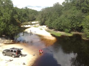
When: 4PM Saturday September 10th 2016
Where: Berrien Beach Launch, at GA 168, 31.159076, -83.045554
Directions: 12.9 miles east of Nashville, GA on GA 168; launch access road is on left (north) side of highway west of the river.
Duration: about 1.5 hours.
Responsible party: Bret Wagenhorst
This outing is Free! But we encourage you to join WWALS today Continue reading
New hydrology report exposes Sabal Trail pipeline risk to Floridan Aquifer
FOR IMMEDIATE RELEASE
Jasper, Florida, July 1st 2016 — Another independent
professional geologist reveals more omissions and discrepancies in pipeline company reports and faults in federal oversight of the Sabal Trail pipeline:
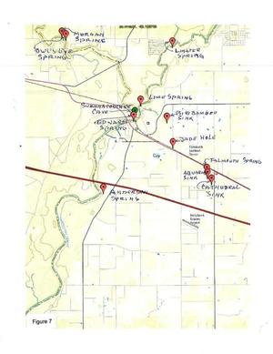 groundflow actually goes the other way,
drilling under a river will change water
flow in the Floridan Aquifer, and there is very high risk of
sinkhole collapse. An indigenous Floridian commissioned this scientific report to protect his mother, the living earth.
This geological report provides compelling additional reasons for the U.S. Army Corps of Engineers (USACE)
to open a new process to evaluate this and other new information.
groundflow actually goes the other way,
drilling under a river will change water
flow in the Floridan Aquifer, and there is very high risk of
sinkhole collapse. An indigenous Floridian commissioned this scientific report to protect his mother, the living earth.
This geological report provides compelling additional reasons for the U.S. Army Corps of Engineers (USACE)
to open a new process to evaluate this and other new information.
Bobby C. Billie, one of the Clan Leaders and Spiritual Leader, Council of the Original Miccosukee Simanolee Nation Aboriginal Peoples, asked professional geologist and hydrologist Peter Schreuder, P.G. to conduct investigations at the proposed Sabal Trail crossing under the Suwannee River from Hamilton County and under U.S. 90 in close proximity to the Falmouth Cave System in Suwannee County.
This Schreuder report concludes about the Floridan Aquifer System (FAS): Continue reading
Hydrogeologic Issues of Concern, HDD under Suwannee River –Peter J. Schreuder 2016-06-23
See press release, New hydrology report exposes Sabal Trail pipeline risk to Floridan Aquifer, and this report is also available in PDF.

Schreuder, Inc. Water-Resources & Environmental Consultants
Directional Horizontal Drilling (HDD) under the
Suwannee River
At Suwannee River State ParkHydrogeologic Issues of Concern
In any review of potential environmental consequences related to the use of Horizontal Directional Drilling (HDD), both the geotechnical and scientific communities can be expected to raise serious concerns when such drilling is done around karst areas, and in regions which over lie the Floridan Aquifer System (FAS), which includes the Upper Floridan Aquifer, and the karstic geologic subsurface features at the location proposed in Continue reading
Ribbon Cutting, new WWTP and Force Main 2016-07-12
Finally ready for prime time and a ribbon cutting:
the new, uphill, out-of-the-floodplain, long-awaited
Withlacoochee Wastewater Treatment Plant (WWTP) and Force Main,
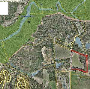 which have not overflowed or otherwise caused sewage spills in the recent rains,
so maybe Valdosta’s chronic problem smelt downstream all the way to the Gulf
is perhaps finally fixed.
Congratulations, Valdosta!
which have not overflowed or otherwise caused sewage spills in the recent rains,
so maybe Valdosta’s chronic problem smelt downstream all the way to the Gulf
is perhaps finally fixed.
Congratulations, Valdosta!
When: 8AM Tuesday July 12th 2016
Where: At the new WWTP on Wetherington Lane, north off US 84, west of I-75 exit 16
Invitations: Paper invitations were mailed last week, including to counties and health departments downstream in Florida, according to Sementha Mathews. If you didn’t get one, contact her, and she says the event is in any case open to the public.
Update 2016-05-30: Sementha Mathews says the paper invitations were mailed Tuesday (day before yesterday), so they should arrive by the end of the week. Arrived.
Contact: Sementha Mathews Continue reading
Where to look for dye from Alapaha Dye test
Update 2023-05-01: Alapaha Swallets Dye Trace Project 2016-10-01.
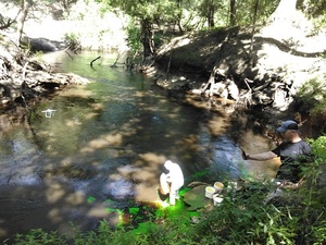 Tom Greenhalgh started putting the dye in the Dead River Swallet about 11:06 this morning,
with Harley Means observing in this picture, plus a drone also taking pictures.
See below for where to look for the dye coming back up in the next few days.
If you see it, please take a water sample for SRWMD. Continue reading
Tom Greenhalgh started putting the dye in the Dead River Swallet about 11:06 this morning,
with Harley Means observing in this picture, plus a drone also taking pictures.
See below for where to look for the dye coming back up in the next few days.
If you see it, please take a water sample for SRWMD. Continue reading
Green Dead River
Alapaha Dye Test

Where to look for the dye coming back up.
-jsq
You can join this fun and work by becoming a WWALS member today!
Alapaha Dye Test
Dead River

Where to look for the dye coming back up.
-jsq
You can join this fun and work by becoming a WWALS member today!