Category Archives: River

Sinkhole Trail on the agenda, Suwannee BOCC, 2016-04-05

Once again, Suwannee County follows Hamilton County’s lead.

Carl McKinney, Suwannee Democrat, 1 April 2016, Suwannee County Commission to discuss Sabal Trail sinkholes,

At its next meeting, the commission will consider sending a letter to the U.S. Army Corps of Engineers, which must issue a permit for the pipeline project.

The letter would mimic one Hamilton County recently voted to send, said Suwannee County Commissioner Wesley Wainwright.

Wainwright asked Continue reading

Withlacoochee River US 41 just before flood, 2016-03-31

Sunday there was parking under the bridge, now that’s under water. What parking? The intended put-in for this Sunday’s Withlacoochee Outing, is just downstream from here, so we’re rescheduling that one for Ray’s Millpond, 875 Rays Mill Pond Rd., Ray City, GA 31645, still 9AM March 20th 2016. Directions: From Valdosta, north on Bemiss Road (GA 125) to Ray City, right on Jones St. to boat ramp.

It’s 14.75 feet, just below 15 foot flood at the Continue reading

FERC makes Hamilton BOCC filing illegible

Does FERC actually look at what counties and other people send it?

Figure 2: LiDAR Map, Suwannee River --Dennis Price to FERC (5 of 8) FERC made the figures illegible in its posting of Dennis Price’s geology report that Hamilton BOCC appended when it forwarded to FERC its site visit request to the U.S. Army Corps of Engineers.

This reminds me of when FERC lost half of Dougherty County’s Sabal Trail resolution and just happened to lose page 3 of Bill Kendall’s letter, the page about lack of need, false pretense, and duress. Does FERC actually care what anybody thinks, other than the industries it “regulates” while they pay all its costs?

FERC Filing 28 March 2016, Accession Number 20160328-0091, “Correspondence from Board of County Commissioners of Hamilton, FL to U.S. Army Corp of Engineers re the Environmental Geology report under CP15-17.” Continue reading

It’s the most votes I’ve ever gotten on anything. –Neill Herring, about GA House against Sabal Trail easements

Pipeline invaders go home to Houston, signed, Georgia legislature.


Georgia Sierra Club’s Neill Herring and Flint Riverkeeper Gordon Rogers at WWALS Watershed Conference in Tifton, 24 August 2013.

Kristi E. Swartz, EEnews, 28 March 2016, PIPELINES: Ga. lawmakers move to block 2 interstate projects,

ATLANTA — Georgia may be friendly to its own electric utility and natural gas companies, but the state Legislature sent a strong message last week to outside corporations that their pipelines are not welcome here.

Continue reading

Ray’s Mill Pond; was Withlacoochee River: Langdale Park to Little River Boat Ramp 2016-04-03

Update 2016-03-31: Rescheduled for Ray’s Mill Pond, due to flood stage on the Withlacoochee River.

Back on the Withlacoochee River in Valdosta, by popular demand from last weekend’s outing! Shuttle: 10 miles or 15 minutes each way We’ll continue next weekend on the next leg down the Withlacoochee River on the Withlacoochee and Little River Water Trail.

Event: facebook or meetup.

When: 9AM Sunday April 3rd 2016

Put in: Continue reading

US 41 access to Withlacoochee River

On the north side of US 41, there’s good access from Val Del Road to the Withlacoochee River.

Turnoff from Val Del Road 30.8961964, -83.3201294 From US 41 (North Valdosta Road), turn north on Val Del Road, and your next right is a turnoff to a gravelled road that bends sharply right into the woods, which leads back to the north side of US 41 and down to the Withlacoochee River. It was a bit muddy in the rain this morning, but there were no big potholes, and the river slope is easy access. The river was high, 9.8 feet, but still well below the 15 foot flood level on the US 41 Gage on this bridge.

Withlacoochee River and US 41 bridge

Continue reading

Georgia legislature overwhelmingly rejects river easements for Sabal “Sinkhole” Trail fracked methane pipeline

Update 2016-03-28: “It’s the most votes I’ve ever gotten on anything.” —Neill Herring of Georgia Sierra Club.

Tuesday and today, Georgia’s elected legislators stood up for the people against a fracked methane pipeline invader:

Y’all! We don’t win votes on the House floor every day, and the effort to keep the state easements for the Sabal Trail pipeline was truly a joy to watch. R’s, D’s, lawyers, community folk, everyone pitched in and it “went down in flames” 34-128 — AJC [Atlanta Journal Constitution] reporter’s words, not mine! Congrats to all the Georgia Water Coalition….

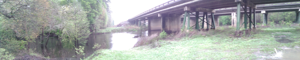
That’s how Georgia Sierra Club’s Colleen Kiernan summed up what happened Tuesday 
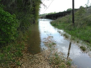
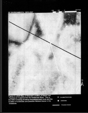
to the river drilling easements for Spectra Energy’s fracked gas Sabal “Sinkhole” Trail pipeline. Yes, the same Spectra of the Algonquin Incremental Market (AIM) Project, PennEast, Atlantic Bridge, South Texas Expansion, the West Coast Pipeline in British Columbia, and far too many other unnecessary pipeline invasions throughout North America.

Georgia Water Coalition organized this excellent result, including Continue reading

Pictures: Staten Road to Langdale Park, Withlacoochee River 2016-03-20

20 people in 17 boats on an astoundingly beautiful rural blackwater river into the biggest city in the entire Suwannee River Basin: Boat parade! 30.9315739, -83.2905044 here are pictures from the WWALS outing from Staten Road Bridge in Lowndes County to Langdale Park on the edge of Valdosta, both in south Georgia, Spring Equinox, Sunday 20 March 2016. Thanks to everyone who came, especially to WWALS Outings Chair Chris Mericle for leading the expedition, and to Georgia Page, Steve, and Travis of the Valdosta-Lowndes Parks and Recreation Authority (VLPRA) for letting us into Langdale Park even though it was closed for renovations. Gretchen Quarterman went on Charlie Walker’s 99.5 KIX Country radio show the next morning to tell everybody about it. Continue reading

Waydown with Dominick Gheesling: Fargo to the Gulf, Suwannee River, 2013

Many of us may have thought of this, but VSU art professor Dominick Gheesling actually did it: way down the Suwannee River from Fargo below the swamp all the way to the Gulf of Mexico.

Waydown: Summer 2013

All of the preparation that could be done was done. My ever-patient wife had given me permission to fall off the grid for a while. My friend Todd Bertolaet helped me load up all of the gear and took me to Fargo, Georgia where I launched on a twenty-nine day expedition, traveling the length of the Suwannee River, via canoe, to the terminus at the Gulf of Mexico. Photographing the length of this historic, iconic, southern river connected me to life and the earth in a manner that I had been missing for a long time.

I am more convinced than ever that Continue reading