Tag Archives: Fargo

More than 100,000 acres and Billy’s Island in West Mims Fire 2017-05-03

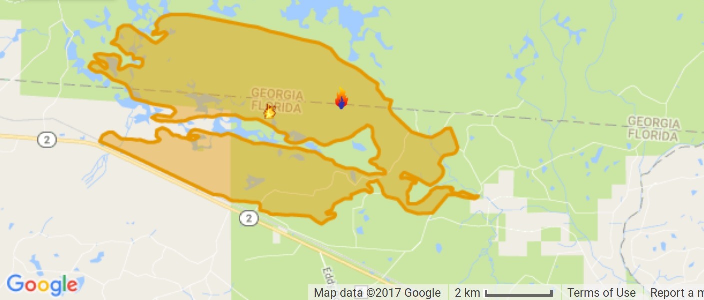
We got smoked here in western Lowndes County yesterday and this morning 60 miles from the West Mims fire as it went up to 107,846 acres in and around the Okefenokee NWR. Many of the fire-fighting numbers went down since last post: remember, the goal is not to put the fire out, rather to contain it. As I write, a big storm just went over here heading that way, so maybe mother nature will take a hand today.

The Valdosta Daily Times has been covering this fire right along, most recently by Terry Richards, VDT, 2 May 2017, Rain barely felt at massive swamp fire,

FARGO — A mild rainfall Monday had little to no impact on the West Mims Fire burning through the Okefenokee Swamp, according to a firefighter.

The blaze, which had burned more than 100,000 acres by Tuesday afternoon, received about a tenth of an inch of rain from a weak cold front that moved through South Georgia Monday.

“It didn’t help,” said Leland Bass, a firefighter and public information officer for the Georgia Forestry Commission.

Maybe they’ll get more rain in the swamp today. Continue reading

West Mims Fire in Upper Suwannee River watershed in Okefenokee Swamp 2017-04-15

Now is not a good time to stay overnight in the Okefenokee Swamp, or to travel at night between Fargo and Moniac, because of smoke.

Lightning started the West Mims fire Thursday, apparently west of Moniac, Georgia in Baker County, Florida. That was in the St Marys River watershed, but the fire has since expanded west and north into the upper Suwannee River watershed and Ware County, Georgia. According to today’s update from InciWeb, the Incident Information System, the fire now involves 13,000 acres and is only 3% contained. Even with 110 firefighters and a variety of equipment, the estimated containment date is two months from now: “Thursday June 15th, 2017 approx. 12:00 AM”. It is a southern fire forest, after all.

Incident Map
Map from InciWeb 2017-04-15. Approximate Location 30.574 latitude, -82.323 longitude.

It’s probably best not to go there at night, since InciWeb says: Continue reading

Update: Fargo to Roline, Suwannee River, 2017-03-18

WWALS Outings Committee Chair Phil Hubbard wrote Tuesday on the facebook event:

Looking forward to the WWALS outing on the historic Suwannee River. Water level currently at Fargo is 93.34′ (2.34′) slightly increasing with the 0.6″ of rain in Fargo yesterday. White Springs is at 52.02′ and rising.

Weather forecast is clear skys and virtually no chance of rain. Temps with an over night low mid 40’s and forecast high of upper 70’s.

What an awesome way to welcome in the return of spring from its brief departure.

Follow the original event blog post for more details.

See you 7AM Saturday, March 18th, 2017, at the Suwannee River in Fargo, Georgia, to paddle into Florida to Roline Landing!

For more outings and events as they are posted, see Continue reading

WWALS Okefenokee Billys Island Outing 2016-12-10

Bittern closeup 30.8347222, -82.3436111 Gators, herons, hawks, and a very hard-to-see bittern, all before Billy’s Island in the Okefenokee Swamp, on a WWALS monthly outing, 10 December 2016.

A few WWALS videos and many pictures and a google map below: Continue reading

Fargo to Roline, Suwannee River, 2017-03-18

Update 2017-03-17: Yes, there’s plenty of water and the weather forecast is fine.

A long downstream paddle on the historic Suwannee River from Georgia into Florida. Fargo Launch @ US 441, Suwannee River In the winter-spring rainy season the water should be high and fast.

Bring the usual personal flotation device, boat paddles, food, drinking water, warm clothes, and first aid kit. There is no good place to take out before the end point, so be prepared to paddle all day. With lunch, swim stops, and bon-bons, of course.

When: 7AM Saturday, March 18th, 2017

Put In: Fargo Ramp

GPS: 30.68297, -82.56105

Take Out: Roline Launch

Duration: 10 hours

Event: facebook, meetup

Free: This outing is Free! And we recommend you support the work of WWALS by becoming a WWALS member today!

Continue reading

Walter Parks, Swamp by Chandelier

You won’t hear this every day. Thanks to Flint Riverkeeper Gordon Rogers for pointing to these Okefenokee Swamp hollers by Walter Parks.

And don’t forget WWALS has an outing 10AM this Saturday December 10th at Georgia’s Stephen C. Foster State Park on the Suwannee River near Fargo, GA, to paddle into the Okefenokee Swamp. Continue reading

Okefenokee Suwannee River Outing @ Fargo, GA 2016-12-10

Update 2017-02-05 Pictures.

Okefenokee West Entrance Trails You can join WWALS for a fall Saturday paddle on the Suwannee River in the Okefenokee swamp. Bring a boat, PFD, and paddle, or you can rent those at the park.

When: 10AM Saturday December 10th 2016

Where: Georgia’s Stephen C. Foster State Park near Fargo, GA

What: Paddle from Billy’s Lake down through the River Narrows to the Suwannee River Sill.

Distance: About 7 miles in about 4 hours Continue reading

Waydown with Dominick Gheesling: Fargo to the Gulf, Suwannee River, 2013

Many of us may have thought of this, but VSU art professor Dominick Gheesling actually did it: way down the Suwannee River from Fargo below the swamp all the way to the Gulf of Mexico.

Waydown: Summer 2013

All of the preparation that could be done was done. My ever-patient wife had given me permission to fall off the grid for a while. My friend Todd Bertolaet helped me load up all of the gear and took me to Fargo, Georgia where I launched on a twenty-nine day expedition, traveling the length of the Suwannee River, via canoe, to the terminus at the Gulf of Mexico. Photographing the length of this historic, iconic, southern river connected me to life and the earth in a manner that I had been missing for a long time.

I am more convinced than ever that Continue reading

Water Resources of the upper Suwannee River Watershed

Even the trend of sinking groundwater levels hasn’t changed a lot in the Georgia parts of WWALS’ watersheds of the Withlacoochee, Alapaha, and upper Suwannee Rivers. Figure 1: Georgia Watersheds Thanks to Tom Potter for the pointer, and we’re inviting someone to talk about this subject at the Withlacoochee and Little River Water Trail Workshop at VSU February 27th, 2016.

WATER RESOURCES OF THE UPPER SUWANNEE RIVER WATERSHED, by Mary M. Davis1 and David W. Hicks2,

1 Ecologist, Continue reading

Sea level gage reports: all USGS gages in WWALS territory in Georgia

All the Suwannee River Basin USGS gages in Georgia just got a new flood level reporting system (except they missed one). Locator Map: Central South Georgia USGS Gages They’ve added a level measurement from sea level, probably not coincidentally about the same as the Florida gages added a level measurement from dry riverbed, so both Georgia and Florida gages now have both measurements. This actually does not affect the WWALS level charts for the Withlacoochee and Little River Water Trail nor for the Alapaha River Water Trail, because those continue to display water levels from dry riverbed. To see this change at all, you have to drill down to the USGS detail pages, for example on the Withlacoochee River at Skipper Bridge Road in Georgia, or near Pinetta, Florida.

National Weather Service Weather Forecast Office, Tallahassee, FL, unknown date, Suwannee River Basin Datum Changes in South Central Georgia,

Starting on October 14, 2015, the National Weather Service in Tallahassee and Jacksonville will make adjustments to the reporting method for water level in the Suwannee River System. This includes river gages in the following rivers or creeks: Continue reading