Tag Archives: Jim Tatum

Union County summarily dismisses phosphate mine application 2017-08-21

Of course they expect HPS II to sue, but this is still good news.

Photo by Jim Tatum, OSFR, of Scott Koons, Executive Director of North Central Florida Regional Planning Council before Union BOCC

Jim Tatum, OSFR, 21 August 2017, Union County Will Consider Mining Comprehensive Plan Amendments, Continue reading

Please choose wisely about phosphate mine vs. water: Suwannee Riverkeeper to Union County, FL 2017-08-21

The biggest asset any of us, all together, will ever own, is water.

Phosphate mining is complicated, but your choice is not.

Please choose wisely and make your moratorium on phosphate mining permanent.

Sent to Union BOCC this afternoon as PDF along with copy of previous letter to Bradford BOCC.

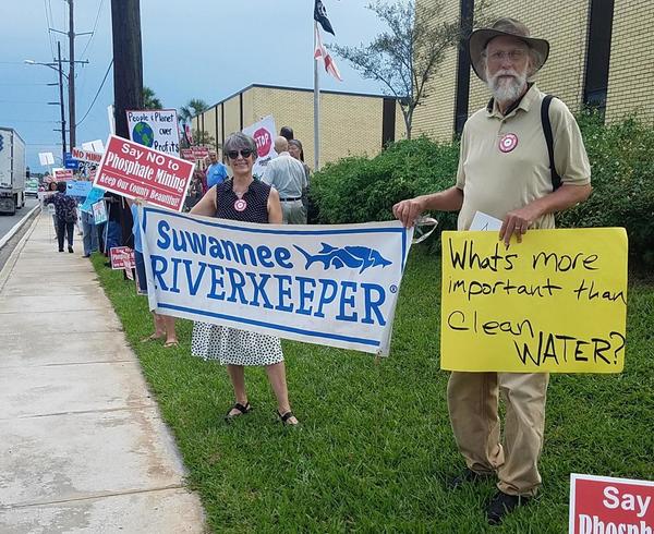
Suwannee Riverkeeper banner at Bradford County Courthouse

August 21, 2017

To: James Tallman, Chairman
Union County Board of County Commissioners
15 NE 1st Street, Lake Butler, FL 32054
(386) 496-4241
ucbocc@windstream.net

Cc:
Scott R. Koons, Executive Director
North Central Florida Regional Planning Council
2009 NW 67th Pl, Gainesville, FL 32653
(352) 955-2200
koons@ncfrpc.org

Re: Phosphate Mine zoning and land use

Continue reading

Videos: Surprise phosphate mining discussion at Bradford County, FL BOCC 2017-07-20

The regular attendees said there would be no fireworks this time. Yet it was a very interesting meeting, especially once the County Attorney asked for scheduling a date to select the consulting engineer about the phosphate mine. The Commissioners and staff discussed August 8 in the morning or August 17 in the evening. Public comment preferred the latter. The County Attorney strongly advised they go ahead and decide when so there will be plenty of time to advertise it. The decision: Thursday evening, August 17, 2017.

Below are links to each WWALS video, followed by a video playlist. See also the agenda.

Proposed HPSII phosphate mine in Union and Bradford Counties, Florida

Update 2017-08-31: More maps and other information in the Phosphate Mining page.

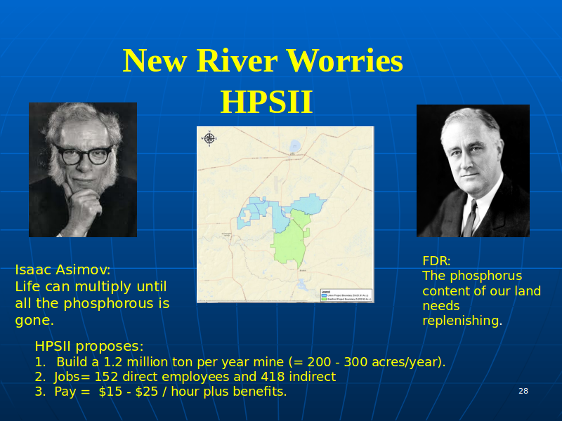
The proposed HPSII phosphate mine on the New River in Bradford and Union Counties, Florida, features in Dave Wilson’s talk from April. HPSII would be upstream from the Santa Fe River, and thus upstream from the Suwannee River.


slide 27 by David Wilson

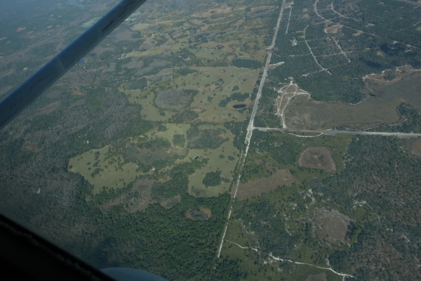
WWALS Watershed Coalition opposes the HPSII phosphate mine. We see no benefit in Union and Bradford Counties suffering effects such as those outlined in Dave Wilson’s slides, and looking like Hamilton County in these aerials: Continue reading

PotashCorp Field Trip Summary –David Wilson 2017-04-13

The moonscape that seems to go on forever while flying over Hamilton County, Florida in a small plane is the PCS phosphate mine, as seen in some WWALS aerials in these slides that David Wilson presented at a Santa Fe River Springs Protection Forum April 13, 2017 at Otter Springs, Florida. Dave is Treasurer of the Board of Florida Springs Institute, and a WWALS member. His slides are published on the WWALS website with his permission.


Slide 14

According to the slides, perhaps JEA is responsible for the low water levels at White Sulfur Springs, formerly a famous resort, now bone dry: Continue reading

Pictures from coal movie and panel, Live Oak, FL 2017-06-09

Reporting from the event, Jim Tatum, OSFR, 10 June 2017, “From The Ashes” Screening by Suwannee St Johns Sierra Club North Florida Working Group,

The North Florida Working Group of the Suwannee St Johns Sierra Club presented an early screening of the documentary “From the Ashes” at the Live Oak Woman’s Club on June 9, 2017….


Susanna Rudolph, Joy Ezell, and Gretchen Quarterman, panelists; Photo: Jim Tatum, OSFR

After the showing Deanna Mericle lead a panel composed of Susanna Randolph, Campaign Senior Representative for Beyond Coal, Sierra Club from Orlando, Joy Ezell, active environmentalist and founder of Help Our Polluted Environment (HOPE) from Perry, and Gretchen Quarterman, Board member and treasurer of WWALS Watershed Coalition, Hahira, Georgia.

Follow the link for more pictures and text.

See also Continue reading

Hunters Creek Pipeline, Sabal Trail, Osceola County, FL 2017-02-07

The south end of Sabal Trail connects its Hunters Creek Pipeline, running through many wetlands and past many subdivisions and malls through Davenport and Kissimmee to connect to Florida Gas Transmission (FGT) just west of Florida’s Turnpike. This is all about six miles south and east of Disney World.

NW past Central Florida Pipeline Corp. to Reunion Compressor Station, 6781 Osceola Polk Line Rd, Davenport, FL 33896,
NW past Central Florida Pipeline Corp. to Reunion Compressor Station, 6781 Osceola Polk Line Rd, Davenport, FL 33896, 28.2610489, -81.5572004

Here are aerials taken Continue reading

PCS Phosphate Mine 2016-10-22

W across PCS Phosphate Mine, 30.4429360, -82.7851800 Is this what you want Bradford, Union, and other counties in Florida to look like? I wonder what effect this phosphate mine had on the much lowered water level of White Springs, or the Suwannee River?

The PCS Phosphate mine in Hamilton County near White Springs and Jasper spread under our Southwings plane while surveying the Sabal Trail fracked methane pipeline 22 October 2016. On board were Southwings pilot Roy Zimmer, photographer Dominick Gheesling, Jim Tatum of Our Santa Fe River, and John S. Quarterman of WWALS. Here are pictures by Jim Tatum, a few videos by John S. Quarterman, and a Google map showing the locations. Continue reading

Gum Springs 3,000 feet from Sabal Trail and lower flow @ WWALS 2017-02-07

Interesting questions about Gum Springs, seen in this picture only 3,000 feet across Marion Oaks Golf Course from Sabal Trail:

Detail, SW corner Marion Oaks, FL,
Picture: Jim Tatum for WWALS on Southwings flight 2017-02-07.

Follow this link for the interactive google map, or it’s also embedded below. Continue reading

Aerials: Sabal Trail hydrostatic test pond at I-75 @ WWALS 2017-02-07

Good questions by Janet Barrow. Who has answers?

Janet Barrow
March 13, 2017 at 4:55 pm

Look at the first photo — “Sabal Trail north from I-75 to the Withlacoochee (south) River.” This shows the hydrostatic discharge point for Spread 5 (at least the site they reported that they will use) and the withdrawal point for Spread 6. Coordinates are: 28°52’47.99″N, 82°5’39.69″W

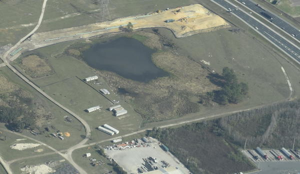
Thanks to Mark Skogman’s long lens on the Southwings flight for WWALS, we can zoom in on that spot.

Hydrostatic test pond at I-75

Janet Barrow
March 13, 2017 at 5:07 pm

Continue reading