Tag Archives: Mark Skogman

Sabal Trail gas into Gulfstream, 2018-01-1-6

It’s a shell game: much of Sabal Trail’s early January burst to maximum capacity went back out through the Gulfstream pipeline in Osceola County, which sent it to a Duke Energy Florida peaker plant in Intercession City and to Florida Gas Transmission (FGT). Presumably some of Sabal Trail’s peak went directly to FPL, but some of it apparently went through Gulfstream to get there. Yet apparently none of it was needed, since in the coldest week of the winter so far, Sabal Trail went back down to almost zero.

100% above ave: IN Sabal Trail Osceola, out Duke Intercession City and FGT Hardee, Charts

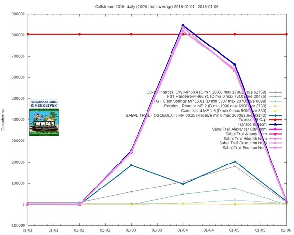
Using data from the various pipeline’s own FERC-required daily information postings, Gulfstream shows “SABAL TRAIL – OSCEOLA IN MP 60.25” suddenly bumping up Continue reading

Hunters Creek Pipeline, Sabal Trail, Osceola County, FL 2017-02-07

The south end of Sabal Trail connects its Hunters Creek Pipeline, running through many wetlands and past many subdivisions and malls through Davenport and Kissimmee to connect to Florida Gas Transmission (FGT) just west of Florida’s Turnpike. This is all about six miles south and east of Disney World.

NW past Central Florida Pipeline Corp. to Reunion Compressor Station, 6781 Osceola Polk Line Rd, Davenport, FL 33896,
NW past Central Florida Pipeline Corp. to Reunion Compressor Station, 6781 Osceola Polk Line Rd, Davenport, FL 33896, 28.2610489, -81.5572004

Here are aerials taken Continue reading

Gum Springs 3,000 feet from Sabal Trail and lower flow @ WWALS 2017-02-07

Interesting questions about Gum Springs, seen in this picture only 3,000 feet across Marion Oaks Golf Course from Sabal Trail:

Detail, SW corner Marion Oaks, FL,
Picture: Jim Tatum for WWALS on Southwings flight 2017-02-07.

Follow this link for the interactive google map, or it’s also embedded below. Continue reading

Aerials: Sabal Trail hydrostatic test pond at I-75 @ WWALS 2017-02-07

Good questions by Janet Barrow. Who has answers?

Janet Barrow
March 13, 2017 at 4:55 pm

Look at the first photo — “Sabal Trail north from I-75 to the Withlacoochee (south) River.” This shows the hydrostatic discharge point for Spread 5 (at least the site they reported that they will use) and the withdrawal point for Spread 6. Coordinates are: 28°52’47.99″N, 82°5’39.69″W

Thanks to Mark Skogman’s long lens on the Southwings flight for WWALS, we can zoom in on that spot.

Hydrostatic test pond at I-75

Janet Barrow
March 13, 2017 at 5:07 pm

Continue reading

FL 200 to Citrus County Line, Sabal Trail @ WWALS 2017-02-07

See Sabal Trail jogs around fancy houses yet run right by a country club and a gated community in Marion County, E. upstream Withlacoochee (South) River, Marion County HDD, 28.9932140, -82.3611430 before its Citrus County Line starts at the Dunnellon Compressor Station and crosses the Withlacoochee (South) River into Citrus County where the houses are too close together to avoid.

Below are Continue reading

Sabal Trail dispenses misinformation even in response to a shooting death

The Palm Beach Post heard of the shooting and did a story, in which Sabal Trail claims their construction is “on target” when clearly it is not.

Susan Salisbury, Palm Beach Post, 3 March 2017, Sabal Trail pipeline shooter killed by law enforcement in Citrus County,

The $3.2 billion natural gas pipeline is slated to begin bringing fuel to Florida Power & Light’s South Florida plants by June. The pipeline has been the subject of numerous protests by people who say its construction and presence will harm the environment and threaten the water supplied from the Floridan Aquifer, but this is the first death known to have occurred in connection to pipeline opposition.

And the opposition has never killed or injured anyone.

Bell Lago, 14130 SW 121st Court, Dunnellon, FL 34432,
Bell Lago, 14130 SW 121st Court, Dunnellon, FL 34432, 29.0170900, -82.3227090
Photograph by Continue reading

Concrete around Sabal Trail pipe on Sand Mine Road 2017-02-07, 2017-02-21

Concreted pipe on Sand Mine Road at Greenbay Road 28.3110870, -81.6904770 In what document did FERC permit concrete wrapped around Sabal Trail pipe?

Concreted pipe detail 28.3100000, -81.6808333 And why was concreted pipe still being trucked in yesterday, two weeks after these aerials?

Pictures by Jim Tatum from Southwings flight for WWALS 7 Feb 2017

Sabal Trail down Sand Mine Road 28.3105110, -81.6738150

Continue reading