He answered a few questions about Falling Creek Aquifer Recharge.

See Questions to SRWMD Director for context. More detail to come.
-jsq
You can join this fun and work by becoming a WWALS member today!

He answered a few questions about Falling Creek Aquifer Recharge.
See Questions to SRWMD Director for context. More detail to come.
-jsq
You can join this fun and work by becoming a WWALS member today!
The Columbia County News has made it easier to ask questions, especially about a very expensive river and aquifer project.
 When: 5:30 PM Thursday 4 February 2016
Where:
Columbia BOCC
372 West Duval Street
Lake City, Florida
What: Why is the SRMD board going to vote next week on sucking up Suwannee River water through a 48″ pipe to Falling Creek Park in an Aquifer Recharge scheme?
Stew Lilker, Columbia County News, 3 February 2016, Suwannee River Water Management Chief at the County 5 Thursday Night: Questions Accepted,
It has been said that fresh clean water is Continue reading
Why is the SRWMD Executive Director on the Columbia County agenda a few days before the SRWMD board meeting with the Falling Creek Aquifer Recharge project?
 Under
“Presentation of Ministerial Matters Not Requiring Public Comment”,
on the
February 4th agenda for the Columbia Board of County Commissioners:
Under
“Presentation of Ministerial Matters Not Requiring Public Comment”,
on the
February 4th agenda for the Columbia Board of County Commissioners:
Noah Valenstein, Executive Director, Suwannee River Water Management District
(1) Introduction
Introduction of what? Of the Continue reading
Update 2023-01-31: Fixed image links that broke when the reference documents vanished from the web.
Public Hearing about the $48 million Falling Creek Aquifer Recharge project and its 48-inch 11-mile pipeline, and several others also involving the upper Suwannee River, 9AM Tuesday, February 9th, 2016, at SRWMD headquarters in Live Oak. Wouldn’t limiting withdrawals make more sense? And why is this the only project listed that’s joint with the St Johns River Water Management District (SJRWMD), and why is drawdown from Jacksonville prominently featured in slides about why this project?
![[Project Location and Potential Pipeline Alignment]](https://www.wwals.net/pictures/2015-01-29--falling-creek-aquifer-recharge/50dcffe5ebd5ecaad9e46d02f682ec68.jpg)
Project Location and Potential Pipeline Alignment
On the SRWMD front page under CALENDAR, Continue reading
Update 2016-02-02: Dropoff locations and other updates.
It’s time to get local, state, and federal elected officials to put a stop
to the Sabal Trail boondoggle that risks our property rights, rivers, aquifer, and air.
 You can sign a petition to Florida (or Georgia or Alabama) elected officials by
printing out the
PDF
for you and your neighbors.
See below for where to send them.
You can sign a petition to Florida (or Georgia or Alabama) elected officials by
printing out the
PDF
for you and your neighbors.
See below for where to send them.
Or, to sign online, Gulf Restoration Network has put up a handy online form that will send your signature and personalized message directly to your members of Congress.
Here’s the text of the PDF: Continue reading
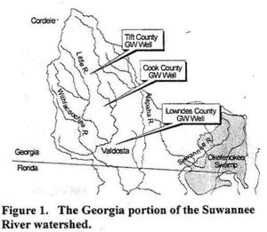
Even the trend of sinking groundwater levels hasn’t changed a lot in the Georgia
parts of WWALS’ watersheds of the Withlacoochee, Alapaha, and upper Suwannee Rivers.
 Thanks to Tom Potter for the pointer, and we’re inviting someone to talk about this subject at the
Withlacoochee and Little River Water Trail Workshop at VSU February 27th, 2016.
Thanks to Tom Potter for the pointer, and we’re inviting someone to talk about this subject at the
Withlacoochee and Little River Water Trail Workshop at VSU February 27th, 2016.
WATER RESOURCES OF THE UPPER SUWANNEE RIVER WATERSHED, by Mary M. Davis1 and David W. Hicks2,
1 Ecologist, Continue reading
Chris Graham reported on facebook from the Alapaha River:
Here what the Alapaha River look like this afternoon near HWY 84 and CSX RR Track. Which it is high but it is going down tho.
The Alapaha was about 11.25 feet on the Statenville gauge at that time. Actually it kept going up. Today it’s at 13 feet.
We’ve been to that CSX railroad bridge before, Continue reading
Due to widespread opposition to Sabal Trail’s invading fracked methane pipeline,
 the Corps extended its deadline 60 days, and FERC slipped a month.
Deadlines coming up this week and next.
the Corps extended its deadline 60 days, and FERC slipped a month.
Deadlines coming up this week and next.
This Friday, December 11, 2015:
Deadline to comment to the U.S. Army Corps of Engineers (USACE)
The Corps wants comments on cumulative effects, including from local governments and other organizations, as well as individuals.
No Corps permit, no pipeline.
All the Suwannee River Basin USGS gages in Georgia just got a new flood level reporting system (except they missed one).
 They’ve added a level measurement from sea level,
probably not coincidentally about the same as the Florida gages
added a level measurement from dry riverbed,
so both Georgia and Florida gages now have both measurements.
This actually does not affect the WWALS level charts for the
Withlacoochee and Little River Water Trail
nor for the
Alapaha River Water Trail,
because those continue to display water levels from dry riverbed.
To see this change at all, you have to drill down to the USGS detail pages,
for example on the Withlacoochee River
at Skipper Bridge Road in Georgia,
or
near Pinetta, Florida.
They’ve added a level measurement from sea level,
probably not coincidentally about the same as the Florida gages
added a level measurement from dry riverbed,
so both Georgia and Florida gages now have both measurements.
This actually does not affect the WWALS level charts for the
Withlacoochee and Little River Water Trail
nor for the
Alapaha River Water Trail,
because those continue to display water levels from dry riverbed.
To see this change at all, you have to drill down to the USGS detail pages,
for example on the Withlacoochee River
at Skipper Bridge Road in Georgia,
or
near Pinetta, Florida.
National Weather Service Weather Forecast Office, Tallahassee, FL, unknown date, Suwannee River Basin Datum Changes in South Central Georgia,
Starting on October 14, 2015, the National Weather Service in Tallahassee and Jacksonville will make adjustments to the reporting method for water level in the Suwannee River System. This includes river gages in the following rivers or creeks: Continue reading
Merrillee Malwitz-Jipson says: “Please consider saying something and be counted.” Here’s How to send an ecomment to FERC.
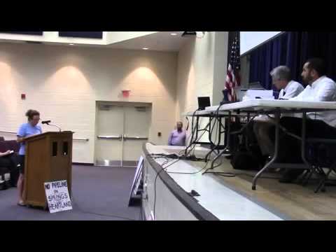 You can ecomment today on FERC docket number CP15-17 against the
Sabal Trail fracked methane pipeline invading Alabama, Georgia, and Florida.
You can ecomment today on FERC docket number CP15-17 against the
Sabal Trail fracked methane pipeline invading Alabama, Georgia, and Florida.
Until December 11, 2015 you can also send comments to the U.S. Army Corps of Engineers against Sabal Trail’s use of rivers and wetlands. You can do this for any of Florida, Georgia, or Alabama.
In Georgia, you can send comments to Continue reading