Tag Archives: Quantity

WWALS Goals for 2014

A surprising number of the Board’s nine goals for 2014 have been accomplished, and some new ones have already been added. What goals should WWALS have for 2015?

Goals accomplished include becoming an IRS 501(c)(3) and raising money for and purchasing insurance. Some we’ve been doing right along: cleanups, including Rivers Alive. Some are so much the core of what WWALS does that we didn’t even list them as goals, but we’ve been doing them anyway: monthly outings and indoor events.

The later-added goal of the Alapaha River Water Trail is Continue reading

Pictures and Videos: Alapaha River Deadfalls, Outing from US82 south @ WWALS 2015-01-17

The Expert paddle on the Alapaha River from US 82, 300x169 Markers, in Alapaha deadfalls, by John S. Quarterman, for WWALS.net, 17 January 2015 found the water level just right and encountered no obstacles it couldn’t float over in the 17 January 2015 WWALS Outing. Paddlers were Heather Brasell, Jack Hartley, Chris and Deanna Mericle, John S. Quarterman, and Bret Wagenhorst. For more information, see the report by outing organizer Bret Wagenhorst. Here are some pictures and videos taken by John S. Quarterman.

Here’s a video playlist, followed by some still pictures: Continue reading

Valdosta in Moultrie discussing flooding Saturday

Did the Withlacoochee River floods the Valdosta City Council all the way to Moultrie to discuss a levee? A levee proposed by the Army Corps of Engineers is top of Valdosta’s retreat agenda tomorrow and Sunday, 10-11 January 2014, at Sundown Farms Plantation, 894 Mack Dekle Road, Moultrie, GA 31768.

Joe Adgie wrote for the VDT 8 January 2014, Valdosta City Council retreating in Moultrie, Continue reading

Alapaha River rainy season?

Veteran boater Bret Wagenhorst asked:

300x214 Alapaha, GA 02316000, in Alapaha River gauge heights over time, by John S. Quarterman, for WWALS.net, 1 December 2014 Is there a defined “rainy season” on the Alapaha? I have seen the water high in December, March, July, and once even in September.

Good question!

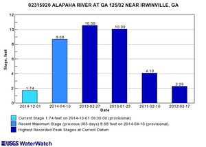
300x214 Irwinville, GA 02315920, in Alapaha River gauge heights over time, by John S. Quarterman, for WWALS.net, 1 December 2014 Looking at the record high water levels for the gauges, they’re all in April, March, February, or January.

Also, the only January one is for Irwinville, the farthest upstream, which also had its highest ever in February with that January high only slightly lower.

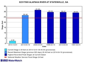
300x214 Statenville, GA 02317500, in Alapaha River gauge heights over time, by John S. Quarterman, for WWALS.net, 1 December 2014 Downstream, Continue reading

Dirty Dozen, sinkhole, aquifer, drinking water, and corrosion –WWALS to FERC about Sabal Trail

“There is no reason anyone in WWALS’ watersheds should accept any risk for the profit of Williams Company, Spectra Energy, and FPL, when any need for the Sabal Trail pipeline is unproven, and in any case the pipeline does not serve anyone in Georgia.”

Filed with FERC 15 November 2014, and appeared in FERC’s ecomment system 17 November 2014 (PDF).

WWALS Watershed Coalition, Inc.
3338 Country Club Road #L336
Valdosta, GA 31605
15 November 2014

VIA ELECTRONIC FILING
Ms. Kimberly Bose
Federal Energy Regulatory Commission
888 First Street NE
Washington, DC 20426

Re: Southeast Market Pipelines Project,
Sabal Trail Transmission, LLC Docket No PFl4-1-000
Williams Transco Hillabee Expansion Project, LLC Docket No PFl4-6-000

Dear Ms. Bose,

I applaud FERC for getting Sabal Trail to move off of the Withlacoochee River in Hamilton County, Florida. However, the same karst limestone geology underlies the same Withlacoochee River and the Floridan Aquifer in Brooks and Lowndes Counties, Georgia, and WWALS Watershed Coalition continues Continue reading

Alapaha River water levels

Update 2025-09-21: Graphs from water.noaa.gov.

300x655 Example 2014-11-03, in Alapaha River Water Levels, by John S. Quarterman, for WWALS.net, 3 November 2014 Update 2016-12-23: graphs from water.weather.gov.

Update 2016-05-31: See sea level gage reports.

Update 2015-04-28: Added flood stages and tentative highest safe and lowest boatable water levels, both above the charts for each gauge and in a summary table. If you have data, please let us know.

Here are water level gauges for the Alapaha River in Georgia and Florida, north to south. The graphs should show the current levels at this time, in feet, plus for most of the gauges a bar graph of selected historic levels.

This is a draft of a concept for use with the Alapaha River Water Trail. See also Alapaha River Rainy Season.

It is also a companion to the similar set of graphs for the Withlacoochee and Little Rivers.

See below for the current Alapaha River water level graphs. Continue reading

GWC DD#9: Sabal Trail pipeline threatens Withlacoochee River and Floridan Aquifer

300x388 DD#9 2014 Page 1 of 2, in GWC DD#9: Sabal Trail pipeline threatens Withlacoochee River and Floridan Aquifer, by Georgia Water Coalition, for WWALS.net, 22 October 2014 Here is the WWALS item #9 in the Georgia Water Coalition Dirty Dozen 2014; I added the links and the illustrations. -jsq

2014’s
Worst Offenses Against 
GEORGIA’S WATER

WITHLACOOCHEE RIVER & FLORIDAN AQUIFER

Gas Pipeline Threatens Southwest Georgia Water, Way of Life

INTRODUCTION:

Southwest Georgians are fighting an invader—one every bit

as worrisome as the boll weevil that destroyed cotton harvests in the 1900s, except this one takes farmers’ land as well as crops. Continue reading

Withlacoochee River & Floridan Aquifer: Gas Pipeline Threatens Southwest Georgia Water, Way of Life, GWC Dirty Dozen

The Withlacoochee River and the Floridan Aquifer affected by the Sabal Trail pipeline is #9 in the Georgia Water Coalition’s Dirty Dozen 2014: A Call to Action, and here’s the press release,

FOR IMMEDIATE RELEASE October 22, 2014 — Today, Georgia’s leading water coalition named its “Dirty Dozen” for 2014, highlighting 12 of the worst offenses to Georgia’s waters. The annual Dirty Dozen shines a spotlight on threats to Georgia’s water resources as well as the polluters and state policies or failures that ultimately harm—or could harm—Georgia property owners, downstream communities, fish and wildlife, hunters and anglers, and boaters and swimmers.

“The Dirty Dozen is not a list of the most polluted water bodies in Georgia, nor are they ranked in any particular order,” said Joe Cook, Advocacy & Communication Coordinator at the Coosa River Basin Initiative. “It’s a list of problems that exemplify the results of inadequate funding for Georgia’s Environmental Protection Division (EPD), a lack of political will to enforce existing environmental protections, and ultimately misguided water planning and spending priorities that flow from the very top of Georgia’s leadership.”

WWALS submitted #9 of the Dirty Dozen:

9. Withlacoochee River & Floridan Aquifer: Gas Pipeline Threatens Southwest Georgia Water, Way of Life

The Sabal Trail pipeline’s path across Continue reading

Sabal Trail Withlacoochee River Alternative and Jasper Open House 21 Oct 2014

Due to fine work by WWALS members Chris and Deanna Mericle in Hamilton County, Florida, 300x391 Withlacoochee River Crossing Route Alternative, Hamilton and Suwannee Counties, Florida (bare), in Sabal Trail Notice of EIS Intent, by John S. Quarterman, for SpectraBusters.org, 15 October 2014 Sabal Trail proposes to move its fracked methane pipeline off of the Withlacoochee River in Florida, and invites the public to an Open House in Jasper, FL Tuesday October 21st about that and other matters. We can ask them to move it off the Withlacoochee River in Georgia, too. And it’s still possible to file ecomments with FERC, and to contact your local, state, and national elected and appointed officials.

In FERC’s 15 October 2014 Sabal Trail Notice of EIS Intent and Route Alternatives, Continue reading

Bowen Mill Pond, Brooks County, Georgia

300x258 Bowen Mill Pond location west of Quitman, in Piscola Creek, by John S. Quarterman, for WWALS.net, 2013 For fishing in Brooks County, GA, try Bowen Mill Pond, west of Quitman. Heading west on US 84, turn right on Barwick Road between the Harveys and the Rite Aid, or right on Shiver Road. Then turn left on Dry Lake Road, and eventually turn left on Bowen Mill Pond road. You’ll see the pond on your right after a while.

Or, if you don’t mind dirt roads, turn off of US 84 onto Few Lane, immediately left onto Hassell Road, and when it curves to the right you’ll see the pond on your left.

Or keep going on US 84 until you see the tiny concrete marker Continue reading