Tag Archives: spring

BMAPs: Agriculture and water at the Suwannee River Basin crossroads 2017-04-13

The conclusion from FDEP in their BMAP presented to an almost-full SRWMD boardroom on April 13, 2017 was: nitrogen runoff into springs and rivers from all sources (the biggest being agriculture, dairies, and poultry) must decrease 83 to 93 percent. For once nobody seemed to argue with research by state agencies. Rather everyone, from representatives of the biggest of farmers to Pilgrim’s Pride to a wide variety of environmental groups seemed aghast at the severity of the situation.

Title slide

This Basin Management Action Plan (BMAP) for the Lower and Middle Suwannee River Basin turns out to include the Withlacoochee River almost to the Georgia line, because Continue reading

Other aquifer models don’t work for karst Floridan Aquifer –Geology Prof. Can Denizman to Suwannee River Partnership 2017-03-03

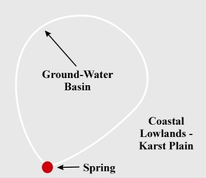
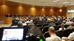
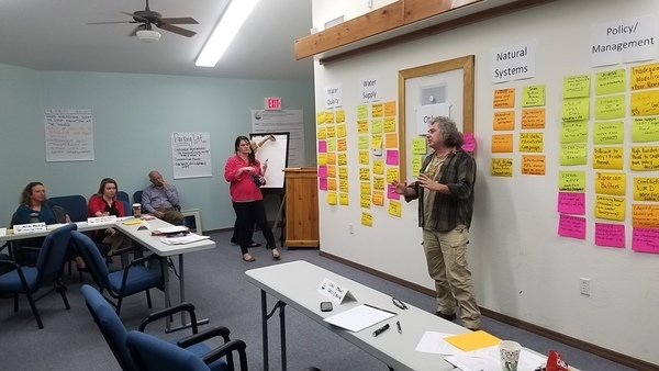
Someone said there’s an actual scientist in the room, so let’s hear from him. So WWALS Science Committee member Geology Professor Can Denizman said a few words about modeling karst limestone aquifers such as the Floridan Aquifer. This was at the March 3, 2017 meeting of the new Environmental Advisory Work Group of the Suwannee River Partnership.

Geology Prof. Can Denizman, VSU, WWALS Science Committee

Here’s video followed by a transcript: Continue reading

Delineation of Spring Protection Areas

These figures tell the story of springsheds in a coastal lowland karst plain such as much of the Suwannee River Basin. Maybe you already know all this, but if you don’t, these pictures may help make sense of Springsheds and Water Withdrawal Permits in the Suwannee River Basin.

Fig. 11_1: Groundwater Basin

A spring is fed from a ground-water basin.

Fig. 11_1: Groundwater Basin

Fig. 12_1: Springshed Protection Area

Continue reading

Springsheds and Water Withdrawal Permits in the Suwannee River Basin

This figure for Florida water withdrawal permits in the Suwannee River springsheds shows by far the largest blue dots for the biggest withdrawal permits in Hamilton County at the location of the PCS Phosphate mine.

Fig. 4: Principal springsheds (red lines) + consumptive use permits (dots sized by withdrawal rate), Florida portion of Suwannee River springshed.

Fig. 4: Principal springsheds (red lines) + consumptive use permits (dots sized by withdrawal rate), Florida portion of Suwannee River springshed.

Thanks to Continue reading

Brooks County, Springs Capital of Georgia

Brooks County can boast three springs of a type usually thought to be only in Florida. Of only about six second magnitude springs in Georgia, three are downstream from US 84: Wade or Blue Springs, sadly defunct; McIntyre Spring, large and easily accessible in the right bank emerging from 4610 feet of caverns back under Brooks County; and Arnold Springs, actually three small springs in the left bank.

Movie: Swimming at McIntyre Spring (1.5M)
Picture by John S. Quarterman for WWALS Watershed Coalition 9 July 2016,
as are all the other pictures herein not otherwise labeled.

And there are numerous shoals between these springs.

Springs

Continue reading

Gum Springs 3,000 feet from Sabal Trail and lower flow @ WWALS 2017-02-07

Interesting questions about Gum Springs, seen in this picture only 3,000 feet across Marion Oaks Golf Course from Sabal Trail:

Detail, SW corner Marion Oaks, FL,
Picture: Jim Tatum for WWALS on Southwings flight 2017-02-07.

Follow this link for the interactive google map, or it’s also embedded below. Continue reading

Videos: NFRWSP Plan passed at joint SRWMD-SJRWMD Board Meeting 2017-01-17

Pretty full The playwright could have added a bit more suspense. After listening to almost two dozen public comments, many recommending tabling the North Florida Regional Water Supply Plan (NFRWSP) or a moratorium on new water withdrawal permits, the boards of the Suwannee River Water Management District and the St Johns River Water Management District each voted unanimously to approve.

Here are WWALS videos of each of the speakers, with a few notes, followed by video playlist of the whole thing. Continue reading

Aerials: Dry Alapaha River and the Alapaha Rise 2016-11-23

The Alapaha River is dry much of the year in most of its Florida run, because it goes underground upstream and comes back up in the Alapaha Rise, which is actually upstream on the Suwannee River from the Alapaha Confluence. The Cody Scarp causes this underground river phenomenon. See also the WWALS Alapaha River Water Trail.

CR 751 bridge, dry Alapaha River, 30.4485760, -83.0968860

CR 751 bridge, dry Alapaha River,

Alapaha River Confluence with Suwannee River, 30.4368660, -83.0982100

Continue reading

Bill Gates, Suwannee Farms, Lakeland Sands, examples from the air 2016-06-21

Here are a few pictures of some Bill Gates properties from the MIDS Southwings flyover of June 21st, 2016, including Lakeland Sands 208th St. to Suwannee Farms 30.0667640, -82.9828050 Suwannee Farms which we previously discovered a Gates subsidiary had bought.

Notice how close these lands are to the Suwannee River or the Withlacoochee River and Madison Blue Spring. Some of them look freshly cleared. Many of them are probably also in Floridan Aquifer recharge zones. There is more identification work to be done. And we have more aerial pictures (and video).

See also the WWALS web page on Corporate Agriculture.

You can join this fun and work by becoming a WWALS member today!

Continue reading

Where to look for dye from Alapaha Dye test

Update 2023-05-01: Alapaha Swallets Dye Trace Project 2016-10-01.

Tom Greenhalgh dying the Dead River, Harley Means, and a drone Tom Greenhalgh started putting the dye in the Dead River Swallet about 11:06 this morning, with Harley Means observing in this picture, plus a drone also taking pictures. See below for where to look for the dye coming back up in the next few days. If you see it, please take a water sample for SRWMD. Continue reading