Tag Archives: Tom Potter

Videos: Tour of Valdosta WTPs 2018-10-03

Thanks to Valdosta Utilities Director Darryl Muse and staff for the Tour of Valdosta wastewater treatment plants Wednesday. Afterwards, I got them to sit down in a conference room and say again the most important points. They said what they had done to prevent future spills like the big ones this year.

Valdosta staff,
Counterclockwise from front: Utilities Director Darryl Muse, Public Information Officer Ashlyn Becton, Environmental Manager Scott Fowler, Mud Creek WTP Superintendent Mud Creek Stanley K. Martin.

We also elicited Valdosta Utilities’ view on the letter establishing the Middle and Lower Suwannee River and Withlacoochee River Task Force, which was mainly Continue reading

Georgia sewage spills from January 2015 through 2018-09-18

Here is every spill reported by all the large wastewater permits in the state of Georgia since the beginning of 2015 through this Tuesday, September 18, 2018. It includes spills in the Suwannee River Basin you probably didn’t know about.

If people downstream want to do something about wastewater coming from Georgia, this data suggests two things: insist Georgia publish spill reports online the same day like Florida and Alabama already do. And help fund WWALS water quality testing so we can find out what’s going on and when.

2015-2018, Valdosta
Just spills with a Valdosta address from 2015 on.

WWALS Science Committee Chair Tom Potter extracted and sorted every spill with an address in Valdosta since the beginning of 2015: Spill-Detail-sorted_Valdosta_2015–2018-09-19. See also web version of this data.

I’ve been asking the City of Valdosta for a list of their spills and locations since at least 2015, and I’ve been collecting reports ad hoc since before then. Finally, we have this list, but not from Valdosta. We had to Continue reading

Madison County meeting about Valdosta sewage, plus Tom Potter of WWALS 2018-08-21

Valdosta sewage discussed yesterday morning in Madison, and in the evening on TV and in the WWALS Water Quality Testing Committee meeting in Valdosta, and again this evening at the Madison BOCC. Emma Wheeler, WCTV Eyewitness News, 21 August 2018, Sewage spills prompt concern over Withlacoochee River safety,

Sewage spills in Valdosta polluting the Withlacoochee River, Screenshots

MADISON, Fla. (WCTV) — A North Florida community is fighting for cleaner water.

Community members in Madison are pushing for safer waterways. It stems from concerns over sewage spills at Valdosta’s Withlacoochee Treatment Plant. The most recent of the spills happened in June.

Many of those concerned said their goal is to have no sewage spill into the river.

“These are public resources, they belong to us,” said Thomas Potter with the WWALS Watershed Coalition. “It’s our duty and our responsibility to make sure that they remain clean.”…

Emma Wheeler shot some footage Continue reading

Rivers bigger and more important that previously thought 2018-06-28

Rivers and streams cover more of the earth’s surface than previously thought, and likely interchange more CO2 and other gases with the atmosphere than previously thought. WWALS Science Committee Chair Tom Potter found this paper.

George H. Allen and Tamlin M. Pavelsky, Science, 28 Jun 2018, DOI: 10.1126/science.aat0636 Global extent of rivers and streams,

Abstract

The turbulent surfaces of rivers and streams are natural hotspots of biogeochemical exchange with the atmosphere. At the global scale, the total river-atmosphere flux of trace gasses such as CO2 depends on the proportion of Earth’s surface that is covered by the fluvial network, yet the total surface area of rivers and streams is poorly constrained. We used a global database of planform river hydromorphology and a statistical approach to show that global river and stream surface area at mean annual discharge is 773,000 ± 79,000 km2 (0.58 ± 0.06%) of Earth’s non-glaciated land surface, an area 44 ± 15% larger than previous spatial estimates. We found that rivers and streams likely play a greater role in controlling land-atmosphere fluxes than currently represented in global carbon budgets.

Fig. 1. Global River Widths from Landsat (GRWL) Database, Figure
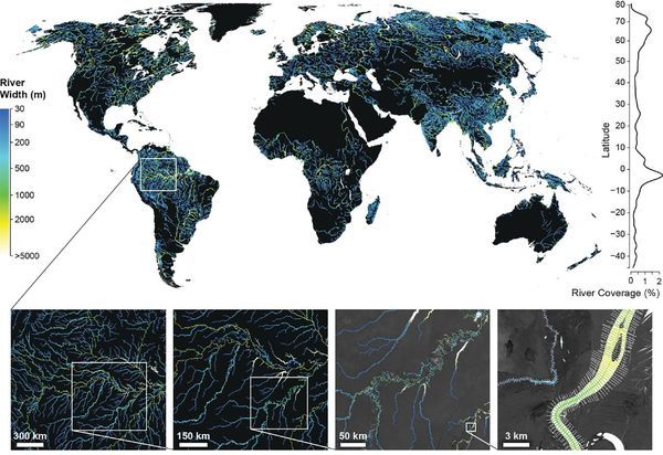
Fig. 1. The Global River Widths from Landsat (GRWL) Database contains more than 58 million measurements of planform river geometry. The line plot on the right shows observed river coverage as a percentage of land area by latitude, and the bottom insets show GRWL at increasing zoom. The rightmost inset shows GRWL orthogonals over which river width was calculated, with only every eighth orthogonal shown for clarity.

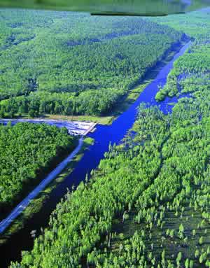
You can see the lower Suwannee River in the above figure.

The authors zoom in on the Amazon River Basin in Brazil, but those last two zooms could easily be Continue reading

Pictures, Azalea Festival 2017-03-11-12

It was a weekend of family fun, with 25,000 of our closest friends and the froggy toss game, in Drexel Park, Valdosta, Lowndes County, Georgia, Spring 2017, on One Mile Branch, upstream of where we did the Cleanup, then flowing into Sugar Creek, and then the Withlacoochee River, just upstream of the newly-rediscovered public access off of Gornto Road, then into the Suwannee River, to the Gulf.

Gretchen, children, game, Froggy toss

The WWALS booth will be back at Azalea Festival Saturday and Sunday, March 10 and 11, 2018.

Not too busy yet, Early

Continue reading

Gornto Road, Valdosta, access to Withlacoochee River 2018-01-24

It could use some markers to keep people on it and off private property, and maybe some loaner kayak wheels, but there is public access to the Withlacoochee River off of Gornto Road in Valdosta.

Tea-colored water, 16:22:37,, Withlacoochee River
Tea-colored water, 16:22:37,, Withlacoochee River 30.8623900, -83.3224600

And a very nice blackwater river it is. Continue reading

Fragility of monoculture agriculture in varying water conditions

They don’t want to say “we don’t know,” but they don’t know. At least they have a working hypothesis about the collapse of the 2017 peanut crop in much of Florida: it has to do with variations in rainfall.

Bob Kemerait, Southeast Farm Press, 22 January 2018, Peanut collapse: Something happened but it’s not clear exactly why,

…For months, University of Florida’s Institute of Food and Agricultural Sciences Extension agents led by Anthony Drew, Mace Bauer and Dee Broughton had been sounding the alarm that an unprecedented collapse of the peanut crop was occurring across large areas of Florida’s production region. Symptoms of this collapse included stunted plants, late-season yellowing and leaves with distinctive marginal leaf necrosis. Where most severe, entire fields wilted in the weeks prior to harvest. Abysmal yields, off by as much as 45 percent, forced some to consider their future in farming if solution could not be found.

During the latter third of the season, Continue reading

GA coal ash committee might consider more safeguards

Georgia Power (and Florida Power & Light and Jacksonville Electric Authority) created the coal ash; they can find ways to dispose of it safely on their own land. And if FPL is shutting down coal plants, how about shutting down its Unit 4 at Plant Scherer, which sends mercury into our Alapaha River. FPL bought into that unit decades ago with the same excuses it’s using for the Sabal Trail fracked methane pipeline now: shutting down a different generating plant, and alleged (now admitted false) need for more electricity.

Georgia Power coal ash pond at Plant Scherer
The Georgia Power coal ash pond at Plant Scherer, seen here in this undated company photo, will be closed over the next three years. Fabian, Liz – Macon Special to The [Macon] Telegraph

Kristina Torres, Atlanta Journal-Constitution, More safeguards could be considered for coal ash ponds in Georgia, Continue reading

Winners, BIG Little River Paddle Race 2017-04-29

FOR IMMEDIATE RELEASE

Adel, Georgia, June 4, 2017 — Dwight Griner of Berrien County, Georgia won for the fifth time. A dozen other boats received prizes, as a record number of people paddled in the Fifth Annual BIG Little River Paddle Race, April 29, 2017. Tifton and Tift County had the most paddlers, but the awards show more boats from Moultrie and Colquitt County. Lowndes had the second most paddlers, and there were two people each from Cook and from far-away Houston and Harris Counties, and one from Thomas County.

[Dwight Griner winner closeup]
Dwight Griner winner closeup

This year’s BLRPR included three popular new attractions: Continue reading

Suwannee River: standard for dissolved organic matter

A primary objective of the WWALS Science Committee is to compile published scientific literature for the Suwannee basin. We are doing this using online search engines including the University of Georgia System Galileo program and Google Scholar. Remarkably, our searches have identified thousands of published scientific papers and reports that link to the keyword, “Suwannee”. Examination of many revealed that they describe research using dissolved organic matter isolated from the Suwannee River near Fargo, GA. This is the material that gives the water its special color.


Photo: Richard T. Bryant, in Pamela P. Holliday, Sherpa Guides, unknown date, The State of the Swamp: The Suwannee River Sill and DuPont’s Mining Proposal Grab attention and Concern in the Okefenokee

Digging further Continue reading