This Sunday, 9AM March 20th 2016, come paddle from Staten Road Bridge
past Shadrick Sink and under the North Valdosta Road Bridge to Langdale Park!
Follow this link for details.
Although Langdale Park will be closed, Parks and Rec. will let us in for this event.
(facebook event, meetup) Continue reading
Tag Archives: USGS
Water Resources of the upper Suwannee River Watershed
Even the trend of sinking groundwater levels hasn’t changed a lot in the Georgia
parts of WWALS’ watersheds of the Withlacoochee, Alapaha, and upper Suwannee Rivers.
Thanks to Tom Potter for the pointer, and we’re inviting someone to talk about this subject at the
Withlacoochee and Little River Water Trail Workshop at VSU February 27th, 2016.
WATER RESOURCES OF THE UPPER SUWANNEE RIVER WATERSHED, by Mary M. Davis1 and David W. Hicks2,
1 Ecologist, Continue reading
Stranded campers rescued from Alapaha River above GA 135 2016-01-16
This is why WWALS recommends filing a float plan, or in this case, a hiking and camping plan.
WALB News Team, 17 January 2016, Campers rescued from rising floodwater, warning issued,
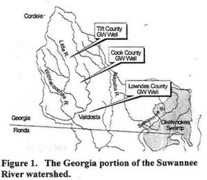
BERRIEN CO., GA (WALB) – The Berrien County Sheriff is sending a warning to residents to stay off the Alapaha River.
“Its not a good time to be camping out on the river,” said Sheriff Anthony Heath.
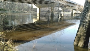
About 11 a.m. on Sunday, four Berrien County campers had to be rescued after they were surrounded by rising floodwaters. A father, his daughter, son, and son’s girlfriend hiked downstream and set up camp at the Alapaha River bridge near state Route 135, south of Willacoochee.
The VDT says they camped on Saturday, and were found the next day. Terry Richards, Valdosta Daily Times, 19 January 2016, page 8A, Stranded campers réscued, Continue reading
Sea level gage reports: all USGS gages in WWALS territory in Georgia
All the Suwannee River Basin USGS gages in Georgia just got a new flood level reporting system (except they missed one).
They’ve added a level measurement from sea level,
probably not coincidentally about the same as the Florida gages
added a level measurement from dry riverbed,
so both Georgia and Florida gages now have both measurements.
This actually does not affect the WWALS level charts for the
Withlacoochee and Little River Water Trail
nor for the
Alapaha River Water Trail,
because those continue to display water levels from dry riverbed.
To see this change at all, you have to drill down to the USGS detail pages,
for example on the Withlacoochee River
at Skipper Bridge Road in Georgia,
or
near Pinetta, Florida.
National Weather Service Weather Forecast Office, Tallahassee, FL, unknown date, Suwannee River Basin Datum Changes in South Central Georgia,
Starting on October 14, 2015, the National Weather Service in Tallahassee and Jacksonville will make adjustments to the reporting method for water level in the Suwannee River System. This includes river gages in the following rivers or creeks: Continue reading
Typical USGS streamgage costs with example near Okapilco Creek
Update 2021-03-09: The funding cost per gauge has gone up, to $22,500, of which usually the USGS contributes about $900.
How much would it cost
to fund the Okapilco Creek gage so it won’t go offline July 31st?
About
$13,600/year, more or less, mostly for field and office labor
and administration, with only 10% for the field equipment.
Since this gage is located in Brooks County, Georgia,
the most likely funding body (after USGS itself)
would be the Brooks County Commission.
Yes, it’s in WWALS watersheds; no, WWALS doesn’t plan to take on
funding streamgages. If some funding organization appeared
that wanted to pass the funds through WWALS, which is a 501(c)(3)
educational institution, that would be possible.
But this seems more like a government issue.
Costs
Continue readingFunding needed for Okapilco Creek gage
In USGS Groundwater Data for Georgia:
The following streamgage will be shut down on July 31, 2015 unless alternative funding can be found:
- 02318700 Okapilco Creek at Georgia Highway 333, near Quitman, Georgia
For questions regarding this threatened streamgage, please contact Tony Gotvald at (678) 924-6648 or agotvald@usgs.gov.
-jsq
Linkage between ground water and surface water –USGS
Yet more documentation on why gouging a pipeline under the Withlacoochee River, or through this Valdosta Limesink area anywhere, would be a bad idea:
In most watersheds (river basins) in Florida the interactions between ground water and surface water typically result in a single dynamic flow system. This direct hydraulic linkage results from numerous karst features (such as sinkholes, conduit systems in the underlying limestone, and springs) that facilitate the exchange of water between the surface and subsurface (fig. 1). Unique problems can arise in protecting water quality in karst areas because of the direct and rapid transport of recharge through conduits to the subsurface and through resurgence by springs. In some areas, recharge from unknown drainage pathways to areas of discharge may contribute to chemical and biological contamination of water supplies. Such contamination in karst areas has been documented by many studies.
Yes, it says Florida, but the geology doesn’t stop at the state line, as USGS spelled out in a 1999 study of the Withlacoochee River. It works like this in Georgia, too: Continue reading
Spring Flood Potential Outlook for Withlacoochee River by NWS
There is potential for “a high impact basin-wide flood event this spring should heavier than normal rainfall occur” in the Withlacoochee Basin.
National Weather Service Tallahasee, FL 240 PM EST THU MAR 5 2015,
Spring Flood Potential Outlook for Southeast Alabama, Southwest
and South Central Georgia, and the Florida Panhandle and Big Bend,
Above normal potential for river flooding this Spring,
Existing Conditions.
In the Withlacoochee, Suwannee Basin…
Continue reading
Regional aquifers crossed, according to Sabal Trail
Sabal Trail seems to have a very constrained idea of the Floridan Aquifer
that doesn’t include areas in for example Colquitt, Brooks, and Lowndes County
that USGS says are in the Floridan Aquifer.
But at least Sabal Trail is admitting its fracked methane pipeline would
cross numerous aquifer systems.
Filed with FERC 2015-02-20 as Accession Number: 20150220-5131, “Sabal Trail Transmission, LLC submits supplemental information on adopted alternatives and information on other reroutes and modifications under CP15-17.” PDF. Continue reading
Withlacoochee River sewage spills, Suwannee River Basin flooding study, and Valdosta’s funded plan to fix its problem
Someone referred to the mid-February Old Statenville Road spill in asking:
What’s happening in your watershed? This is the most recent of several sewage overflow issues I’ve been reading about.
Brief answer: this flooding issue is one of many reasons WWALS Watershed Coalition was formed; we’ve been on it since then; the City of Valdosta is being fixed the immediate problem; however there’s a much bigger problem throughout the entire Suwannee River Basin that the Army Corps of Engineers is studying.
Long answer:
This has been going on for years, especially starting with the
700-year flood in 2009, which overflowed the City of Valdosta’s
Withlacoochee Wastewater Treatment Plant (WWTP) and backed up sewage
out of manholes, in addition to rivers and streams running over
roads and bridges; see this
USGS two-pager on that.
Larry Hanson, Valdosta City Manager, presented to Continue reading