Tag Archives: basin

Hahira passed resolution supporting Withlacoochee and Little River Water Trail 2018-02-01

Many thanks to the Hahira Mayor and Council for passing a resolution in support of the water trail for the rivers that run less than six miles west (the Little River) and east (the Withlacoochee River) of the Hahira Courthouse where they met.

Clear view, City Council
Left to right: Council Patrick Warren (District 3) Mayor Pro Tem Kenneth Davis (District 2), Mayor Bruce Cain, Empty Chair for City Attorney Rob Plumb, City Manager Jonathan Sumner, Council Terry Benjamin (District 1), Council Mason Barfield (District 4), City Clerk Lisa Mashburn.

I spoke briefly at their Work Session, Tuesday, January 30, 2018, outlining the Withlacoochee and Little River Water Trail (WLRWT) and the resolution, and I invited them to upcoming WWALS outings. Several of the Council had positive comments.

Council Patrick Warren also mentioned his fear of Continue reading

Hahira is sixth resolution supporting GA HR 158, now in statehouse 2018-02-01

HR 158 may be scheduled for a vote in the Georgia House as soon as tomorrow. Help dedicate state fees to their intended purposes: please contact your Georgia House Representative or Georgia State Senator (follow the links for contact information) and ask them to pass HR 158. If you don’t know who your Georgia Representative or Senator are, see Georgia My Voter Page.

Hahira is the most recent of six local governments representing the majority of the population in the Suwannee River Basin in Georgia, in five Georgia House districts and two Senate districts, that have passed a resolution supporting Georgia HR 158 against state fee diversions, with five stories and an editorial in the biggest circulation newspaper in the Basin. More local resolutions passed elsewhere in the state, but that ain’t bad for the Suwannee River Basin.

Camera, City Council

  1. 2018-01-08 Lanier County, House District 176 (Jason Shaw), Senate District 8 (Ellis Black) Continue reading

Georgia Adopt-A-Stream

First in a series of Where is the existing water quality data? In Georgia, it’s in Georgia Adopt-A-Stream’s database, online maps, charts, etc. And Adopt-A-Stream is not just for Georgia anymore.

Suwannee River Basin, Maps

The data record for the Suwannee River Basin is embarrassingly empty.

Suwannee River Basin, Maps

TN, SC, GA, FL, Maps

However, it turns out there’s data in Tennessee, South Carolina, and in Florida way down to Key West. So Georgia Adopt-A-Stream is a candidate for keeping Suwannee Riverkeeper data. Of which there turns out to be quite a bit already for Florida, Continue reading

Global Croplands, Suwannee River Basin

You can see on these maps that the Suwannee River Basin is massively agricultural, except where it’s forestry or swamp or other wetlands. Thus it’s no wonder that most of the nitrate runoff problem here is due to agriculture, as shown in the Basin Management Action Plans (BMAPs).

Basin Wide, Maps

WWALS Science Committee Chair Tom Potter points to this Global Croplands map to illustrate the BMAP issues. The question remains of whether agricultural best management practices as advocated in the recent BMAP meetings will be sufficient to deal with the problem, considering they haven’t decreased it in the past decade.

Global Croplands About: Continue reading

Suwannee River Basin Maps

Update 2019-02-13: And a version with Landings. See also Water Trails, with more detailed maps and access points.

Nobody seems to have done this, so we did: a map of the Suwannee River Basin, with the major watersheds and the Estuary shaded, and all the major rivers, plus many of the creeks. Bonus: springs! Narrow, Suwannee River Basin Click on this link for an interactive google map of the Suwannee River Basin.

The river traces come from USGS and Chris Graham. The watershed boundaries are from USGS. The springs are from the Florida Springs Institute, plus four Georgia springs collected by WWALS.

The eight-digit hydrologic unit codes (HUC8) for the Suwannee River Basin are: Continue reading

Lead TMDL Evaluation for Three Segments in the Suwannee River Basin 2016-06-01

Through November 24, 2017, public comment is open about lead in our Georgia watersheds, in a new proposed Total Maximum Daily Load Evaluation.

Map: Streams Not Supporting Designated, Lead Criteria Violation

Map: Streams Not Supporting Designated, Lead Criteria Violation

Georgia EPD, Proposed TMDLs, 29 September 2017, NOTICE OF AVAILABILITY OF REVISED TOTAL MAXIMUM DAILY LOADS FOR WATERS AND POLLUTANTS OF CONCERN IN THE STATE OF GEORGIA, Continue reading

Rivers Seven Days After Irma 2017-09-17

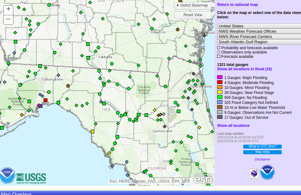
Looks like we may finally see Action stage tomorrow on the Withlacoochee River above Valdosta @ Skipper Bridge Road. This is upstream from Valdosta’s Withlacoochee Wastewater Treatment Plant, so it’s a good thing that didn’t spill during Irma. The Alapaha River at Statenville peaked Tuesday and probably would be a fine ride (what shoals?) today. The New and The Santa Fe Rivers are still flooding, and that’s still raising the Suwannee River all the way to the Gulf, and there’s minor flooding all the way up at Fargo, so another surge of high levels may follow on the Suwannee. The I-75 Santa Fe River bridge never did close.

2017-09-17 Withlacoochee River above Valdosta @ Skipper Bridge Road

The Suwannee River at White Springs peaked Continue reading

Where nobody lives in the Suwannee River Basin

Obviously nobody lives in most of the Okefenokee Swamp or the Osceola National Forest, but also most of Clinch County is unpopulated west of the Swamp, as is much of the Gulf coast along the Suwannee River Estuary, from Cedar Key north to Horsehoe Bay, plus large parts of Dixie and Lafayette Counties west of the Suwannee River.

Screenshot 2017-05-12 13-15-46
Nobody Lives Here: Unpopulated U.S. Census Blocks, screenshot by jsq from interactive map by mapsbynik.

Update 2017-06-20: As someone pointed out, rangers do live in the Okefenokee Swamp, presumably in the white area along the access road.

Cedar Key is the island at the bottom of the map, and from a bit north on the Gulf Coast you can follow Continue reading

Suwannee River: standard for dissolved organic matter

A primary objective of the WWALS Science Committee is to compile published scientific literature for the Suwannee basin. We are doing this using online search engines including the University of Georgia System Galileo program and Google Scholar. Remarkably, our searches have identified thousands of published scientific papers and reports that link to the keyword, “Suwannee”. Examination of many revealed that they describe research using dissolved organic matter isolated from the Suwannee River near Fargo, GA. This is the material that gives the water its special color.


Photo: Richard T. Bryant, in Pamela P. Holliday, Sherpa Guides, unknown date, The State of the Swamp: The Suwannee River Sill and DuPont’s Mining Proposal Grab attention and Concern in the Okefenokee

Digging further Continue reading

Delineation of Spring Protection Areas

These figures tell the story of springsheds in a coastal lowland karst plain such as much of the Suwannee River Basin. Maybe you already know all this, but if you don’t, these pictures may help make sense of Springsheds and Water Withdrawal Permits in the Suwannee River Basin.

Fig. 11_1: Groundwater Basin

A spring is fed from a ground-water basin.

Fig. 11_1: Groundwater Basin

Fig. 12_1: Springshed Protection Area

Continue reading