
Southwings flight for WWALS, pilot Roy Zimmer.
Yes, it’s Sabal Trail pipe in an unregistered pipe yard.
-jsq

Southwings flight for WWALS, pilot Roy Zimmer.
Yes, it’s Sabal Trail pipe in an unregistered pipe yard.
-jsq
 Monday Sabal Trail asked FERC
to
add a contractor yard in Colquitt County,
and to change routing
under a small stream.
No rush: Sabal Trail wants approval by tomorrow,
Thursday, October 20th 2016.
Presumably because they’re racing hell-for-leather to meet their May 2017
in-service drop-dead date, after which (according to FPL’s RFP)
they could forfeit a $200 million bond or lose the contract.
Monday Sabal Trail asked FERC
to
add a contractor yard in Colquitt County,
and to change routing
under a small stream.
No rush: Sabal Trail wants approval by tomorrow,
Thursday, October 20th 2016.
Presumably because they’re racing hell-for-leather to meet their May 2017
in-service drop-dead date, after which (according to FPL’s RFP)
they could forfeit a $200 million bond or lose the contract.
Here, courtesy of Lowndes Area Knowledge Exchange (LAKE), are Sabal Trail’s October 17th 2016 maps of that stream, plus Sabal Trail’s April 2016 maps of where it wants to cross the stream it flows into, Hog Creek and that stream’s downstream Okapilco Creek.
We’ve already seen where Sabal Trail is drilling under the Withlacoochee River between Valdosta and Quitman, Georgia and under the Suwannee River in Suwannee River State Park. Plus there’s an encampment of water protectors in Suwannee County.
According to
Gregory Payne,
Sabal Trail only recently put up those No Trespassing signs on their easement,
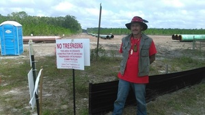 after Gregory moved in with a peaceful nonviolent encampment with permission from the landowner.
While trying to stop the pipeline,
the campers are making sure Sabal Trail does not block the landowner’s access.
This is not a WWALS event or activity, but it is happening in WWALS watersheds, so I went to report on it yesterday, Sunday October 16th 2016.
after Gregory moved in with a peaceful nonviolent encampment with permission from the landowner.
While trying to stop the pipeline,
the campers are making sure Sabal Trail does not block the landowner’s access.
This is not a WWALS event or activity, but it is happening in WWALS watersheds, so I went to report on it yesterday, Sunday October 16th 2016.
Gregory Payne says Continue reading
At Wanee

More about that. We’ll be there today, Saturday, and Sunday, too. Come on down!
-jsq
You can join this fun and work by becoming a WWALS member today!
Small, big, huge, and PDF versions of each and every one of the 144 alignment maps FSC filed with FERC in May 2016 are available online courtesy of Lowndes Area Knowledge Exchange (LAKE).
![[21040-510-ALS-00132 STA: 6250+00 TO 6300+00, MARTIN COUNTY, FLORIDA]](https://www.l-a-k-e.org/govt/ferc/2016-05-20--fsc-implementation-plan/small/20160520-5173-31474761-0007.jpg)
21040-510-ALS-00132 STA: 6250+00 TO 6300+00, MARTIN COUNTY, FLORIDA
PDF
The map shown here is where FSC crosses SW Martin Highway (FL 141) between Okeechobee City and Juno Beach, Florida. There will be a rally against this pipeline in Juno Beach at FPL HQ Friday and another in Okeechobee City Saturday.
Follow the link for details of what, and how you can help.
For maps of the rest of the Southeast Market Pipelines Project (SMPP), see SMPP.
-jsq
You can join this fun and work by becoming a WWALS member today!
Taking it to the source: the headquarters of FPL, whose ratepayers are on the hook for $3 billion for the Transco → Sabal Trail → FSC fracked methane pipeline boondoggle through Alabama, Georgia, and Florida, Sierra Club and Indian Riverkeeper are holding a Rush Hour Rally this Friday, October 14th 2016 in Juno Beach, Florida; see press release for details. If you can’t get there, there are other events all over Florida and beyond. Remember, FPL admits no need for new electricity until 2024, so there’s no more excuse for Sabal Trail.

The facebook page Protect Florida Against Sabal Trail attempts to keep track of upcoming rallies against Sabal Trail or its ugly stepsisters, which are popping up practically daily. Here are some events scheduled starting this weekend: Continue reading
WWALS Watershed Coalition, the Waterkeeper® Alliance Affiliate for the upper Suwannee River, will have a table at the
Suwannee River Roots Revival
at Spirit of the Suwannee Music Park, 13-16 October 2016.
 That’s starting 4PM tomorrow, Thursday October 13th.
This is the festival we wrote has roots going back to the 1950s in the Suwannee River Jamboree radio show.
If you’d like to help with the WWALS table, Continue reading
Come hear how the Standing Rock Sioux in North Dakota are protecting their water from the same fossil industry and the same companies that want to drill the Sabal Trail pipeline under our Withlacoochee and Suwannee Rivers in south Georgia and north Florida.
 When: 7PM Wednesday September 28th 2016
What: The Pipeline Controversy
Where: Cypress Room
University Center
Valdosta State University Continue reading
U.S. Congress member Gwen Graham (FL-02) and nature photographer John Moran will keynote the Florida Springs Restoration Summit in Ocala Friday Sept. 30th through Sunday Oct. 2nd at the College of Central Florida.
 Gainesville Sun, 8 September 2016,
Robert Knight: Fill vacuum in state leadership to fix springs,
Gainesville Sun, 8 September 2016,
Robert Knight: Fill vacuum in state leadership to fix springs,
The private, non-profit Florida Springs Council was organized by springs’ advocates to Continue reading
Update 2019-03-19: The google map now includes Florida Southeast Connection (FSC) and FPL’s Martin County to Riviera Beach (MR-RV) pipeline to the sea, which FPL in 2018 got FPSC and FERC to roll into FSC. See also Stop FERC Shirking LNG Oversight.
 Update 2016-12-13: The google map now includes the Sabal Trail path digitized for all of Georgia and to the end of the line in Florida south of Orlando.
Update 2016-11-29: In the google map, extended the Sabal Trail alignment maps localized by LAKE for Mitchell, Colquitt, Brooks, and Lowndes Counties, Georgia, and Hamilton, Suwannee, and Gilchrist Counties, Florida to just north of Bell, FL, plus on the crowdsourcing map, WWALS aerials of Gilchrist County.
Update 2016-11-03: Added to the google map digitized path and maps for Gilchrist, Alachua, and part of Levy Counties, FL.
Update 2016-10-31: Added to the google map: Aerials: Suwannee, Ocholockonee, Withlacoochee, Santa Fe Rivers, Okapilco Creek, Sabal Trail Moultrie CY3-6 @ WWALS Southwings 2016-10-22.
Update 2016-10-30: The google map now has all Sabal Trail’s alignment maps from 7 April 2016 linked in for (part of Gilchrist 2016-11-29), Suwannee and Hamilton Counties, FL and Lowndes, Brooks, Colquitt, and Mitchell Counties, GA. Aerial pictures from the WWALS Southwings flight of October 22nd 2016 are also linked in, starting with US 84 HDD Withlacoochee River and US 129 HDD Santa Fe River.
Update 2016-09-14: All 527 alignment maps Sabal Trail filed with FERC in April 2016, in small, big, huge, and PDF formats, courtesy of Lowndes Area Knowledge Exchange (LAKE).
Update 2016-09-23: Added Depressions within 1 mile of Sabal Trail in Hamilton, Madison, and Suwannee Counties, Florida. The pipeline path doesn’t go through Madison County, but it comes closer than a mile, and not even two miles from Madison Blue Spring.
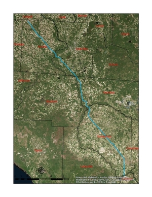
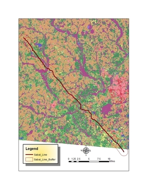
These maps show the path Sabal Trail is gouging its fracked methane pipeline through south Georgia and north Florida, with comparisons to some geological features, including Okapilco Creek, Withlacoochee River, Suwannee River, Suwannacoochee Spring, Falmouth Spring, the Cathedral Cave System, and numerous karstic features, some of them sinkholes.
 This digitizaiton is thanks to Continue reading