Tag Archives: GA 76

High, fast, and dirty: Withlacoochee River, Okapilco and Crooked Creeks 2020-04-25

WWALS testers Conn and Trudy Cole noted for these four Saturday test stations: “All of these were high and flowing fast.” Also dirty. You can help WWALS buy supplies for water quality testing.

[All four dirty]
All four dirty

You don’t even have to be a trained tester to tell none of those Petrifilms looks good, and that bottom row is by far the worst.

cfu/100 mL
E. coli
Where
444 Little River @ GA 76 (Cook County Boat Ramp)
1,200 Withlacoochee River @ US 84
900 Okapilco Creek @ US 84
TNTC Crooked Creek @ Devane Road

All four locations were above the 410 single-sample limit, and two were above the 1,000 alert limit.

As expected, every location tested was filthy. Crooked Creek at Devane Road was so much higher that it could only be recorded as Too Many To Count (TNTC). That’s in the left middle of this map, where Continue reading

Reroute: Little River, Cook County Boat Ramp upstream to Stone Bridge 2020-05-16

Update 2020-05-26: Pictures: Stone Bridge paddle from Cook County Boat Ramp (GA 76) 2020-05-16.

Update 2020-05-21: Three Little River Landings in Swim Guide 2020-05-21

Update 2020-05-20: Clean weekend 2020-05-17.

Changed to put in at Cook County Boat Ramp on GA 76 and paddle upstream past Stone Bridge, and then back. This avoids the outings problem during the stay-home period of the novel coronavirus pandemic: no shuttle, so no crowding together. Yes, boating is not just permitted, it is encouraged by the state of Georgia; see Florida and Georgia Boat Ramps Status 2020-04-09. To keep it that way, everyone please remember to stay 6 feet apart on land and 10 feet apart on the water.

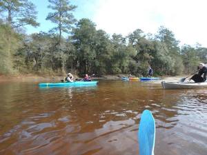
This is a leisurely paddle on a very seldom-paddled stretch of wild south Georgia blackwater river, the Little River, between Adel and Barney.

When: Gather 9:30 AM, launch 10 AM, Saturday, May 16, 2020

Put In: Cook County Boat Ramp, Mile 31.41. 966 Quitman Highway (GA 76), Adel, GA 31620, in Cook County.
Between Adel and Barney, southeast side of GA 76, northeast side (left bank) of Little River, gravel ramp. Also known as Cook County Landing (GDOT). Left or right bank means when facing downstream.

GPS: 31.040042, -83.493085

Landmark 1: Stone Bridge, 31.04962, -83.49932, Mile 32.36, about a mile upstream from Cook County Boat Ramp.

Take Out: Same as Put In.

Bring: the usual personal flotation device, boat paddles, food, drinking water, warm clothes, and first aid kit. Also trash pickers and trash bags: every WWALS outing is also a cleanup. These days, a facemask would not be amiss.

Free: This outing is free to WWALS members, and $10 (ten dollars) for non-members. We recommend you support the work of WWALS by becoming a WWALS member today!

Event: facebook, meetup

Burt Kornegay, March 24, 2018, Stone Bridge
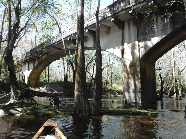
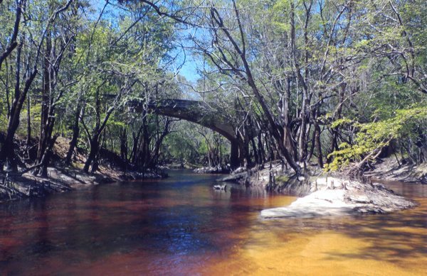
Photo: Burt Kornegay, March 2018, of Stone Bridge over Little River, SW of Adel, GA.
More about Stone Bridge, including more pictures: Stone Bridge, Little River, by Dan Phillips 2016-08-01.

Duration: 2 hours (depending on how far upstream we go)

Shuttle: None, so no crowding together.

Landmark 2: Continue reading

Filthy Crooked Creek, clean Okapilco Creek upstream 2020-03-20

Update 2020-03-26: Cleaner downstream with no rain 2020-03-24.

Two days after rain, Crooked Creek was still filthy Friday. Some of that probably got into the Withlacoochee River. WWALS continues testing. You can help.

[Too high]
Too high
For context and the entire WWALS composite spreadsheet of all known data sources see https://wwals.net/issues/testing/.

This is in Brooks County, Georgia.

[Crooked Creek @ Monument Church Road]
Crooked Creek @ Monument Church Road

Crooked Creek at Monument Church Road was bad enough, 1,366 cfu/100 mL E. coli, which is above the Georgia Adopt-A Stream alert level of 1,000. See also what do these numbers mean?

[Crooked Cr @ MCR]
Crooked Cr @ MCR

The stench was mostly coming from Continue reading

Still bad Saturday: Withlacoochee and Suwannee River to Mayo and Luraville 2020-02-29

Update 2020-03-02: Suwannee River contamination running downstream to the Gulf 2020-03-01.

Still bad water quality all the way to Luraville and Mayo, according to FDOH Friday for the Withlacoochee River and SRWMD Saturday for the Suwannee River.

A catalog of WWALS, Valdosta, Lowndes County, FDEP, FDOH, and SRWMD results is at wwals.net/issues/testing/. You can help.

[2020-02-29--excerpt-WWALS-composite-wq-results]
2020-02-29–excerpt-WWALS-composite-wq-results
Extract from WWALS composite water quality test results from Georgia and Florida.

A couple days ago I remarked that nobody knew the water quality of the Suwannee River downstream from Dowling Park, because nobody had tested that. Saturday SRWMD did test down at the Hal W. Adams Bridge on FL 51, between Mayo and Luraville, and the result was above the alert level of 1,000, while at Dowling Park it was back below the too-high level of 410. Apparently something was moving down the Suwannee River.

We still don’t know what’s going on downstream of FL 51, for example at US 27 (Branford) or CR 340 (Rock Bluff Ramp). This is more evidence that we need regular, frequent, testing at all these locations, not just after a spill or other upstream alert.

Thanks to Katelyn Potter of the Suwannee River Water Management District (SRWMD) for forwarding the Florida updates late Sunday evening. Thanks to SRWMD and Madison Health for testing on a weekend, and to Florida Department of Health (FDOH) for helping. Thanks to Florida Department of Environmental Protection (FDEP) and Julie Espy for posting results on an FDEP web page. No update on Valdosta’s results website for Friday yet.

WWALS testers Conn and Trudy Cole got Continue reading

Not good: Withlacoochee River & Okapilco Creek 2020-02-11

Update 2020-02-18: Withlacoochee still not clean Thursday but not alarming in Florida results 2020-02-13.

Update 2020-02-14: Fixed typo; apparently FDOH tests were collected Monday, February 10, 2020.

Lowndes County’s upstream results for Tuesday, February 11, 2020, are as bad at US 84 as FDOH’s result at CR 150 (Sullivan Launch) the previous day.

Yes, Okapilco Creek downstream of US 84 is especially bad. But Okapilco Creek has more E. coli than anyone would like upstream at GA 76, too. And no, Valdosta is still not off the hook.

We still need to find out where all this contamination is coming from. You can help.

[Not Good Results 2020-02-11]
Not Good Results 2020-02-11
Thanks to Lowndes County Chairman Bill SLaughter for these Tuesday results, which are on the WWALS website, along with the full WWALS composite result table going back to December 10, 2019.

These results are much different from Lowndes County’s tests of Wednesday, February 5. There’s been no rain to speak of since last Thursday, February 6, five days before these recent Tuesday tests, so what’s going on?

[Quitman Gauge (US 84)]
Quitman Gauge (US 84)

Rain upstream is washing something downstream.

[Rain the week before]
Rain the week before

Much of that rain fell upstream and is still coming downstream. More than an inch fell that Thursday at the Continue reading

Clean Withlacoochee River; dubious Okapilco Creek; and rain 2020-02-05

Update 2020-02-12: Madison Co., FL Withlacoochee River Bacterial Advisory 2020-02-11.

Good another Wednesday: Lowndes County water quality results for the Withlacoochee River. Meanwhile, about an inch of rain registered upstream Thursday. We will have more WWALS results in a day or so. The only way to tell what is in our waterways is regular, frequent, closely-spaced testing. You can help.

[Good Withlacoochee]
Good Withlacoochee
Thanks to Lowndes County Chairman Bill Slaughter for these Lowndes County results.
Along with the WWALS composite results spreadsheet, they are on the WWALS website.
There are no new Florida results; the Florida agencies stopped testing after Continue reading

Clean Withlacoochee, Okapilco Creek (mostly), and Little River 2020-02-02

Update 2020-02-08: Clean Withlacoochee River; dubious Okapilco Creek; and rain 2020-02-05.

Even better news: clean everywhere WWALS tested Sunday on the Withlacoochee River, Little River, and Okapilco Creek. If this keeps up, eventually we, and presumbably Lowndes County, will remove our warning signs. We’ll make some inquiries in Quitman while waiting for Lowndes County’s data upcoming this Wednesday.

At least weekly ongoing testing is still needed. What Lowndes County keeps seeing in Okapilco Creek illustrates that while Valdosta is chronically the biggest problem, and Valdosta has some remediation to do, it’s not the only source of contamination. The only way to tell when our rivers are clean or not, so we can market eco-tourism and gradually lift the reputational stigma on our rivers, is regular, weekly, water quality testing.

You can help.

[With reference dog]
Photo: Suzy Hall, of the Withlacoochee RIver downstream of Knights Ferry Boat Ramp, With reference dog.

Suzy Hall tested the Continue reading

Stone Bridge, Little River, by Dan Phillips 2016-08-01

Here’s a piece of south Georgia history, Stone Bridge, on the Little River, between Adel in Cook County and Barney in Brooks County, on the Withlacoochee and Little River Water Trail (WLRWT).

On a summer day, Stone Bridge

Dan Phillips wrote about this picture he took: Continue reading

Sabal Trail still wallowing in water, GA 76 between Morven and Quitman, GA

Looks like they already bored under the road with their red pipe, but can it be good for the pipe to be sitting in water? And after they cover it over with dirt, will it still be low enough to be in the water table?

 -jsq, John S. Quarterman, Suwannee RIVERKEEPER®

You can join this fun and work by becoming a WWALS member today!

Cook County Landing (GA 76) to Folsom Bridge (GA 122), Little River 20162017-01-14

Not a great boat ramp but public access it is. In January the water should be up like a year ago at this three-hour tour of the idyllic Little River between Brooks County and Cook and Lowndes Counties, Georgia. There should be no need to drag boats, like there was in July.

When: 10 AM Saturday January 14th 2017

Put In: Cook County Landing (GA 76) between Adel, Cook County and Barney, Brooks County, Georgia

GPS Coordinates: Continue reading