Every few years Banks Lake gets drained is an effort to stymie unwanted aquatic vegetation.
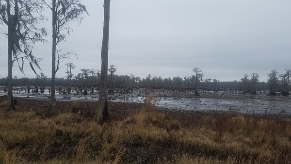
Hydrilla verticillata forms dense mats at the surface of the water. The dense mats can Continue reading

Every few years Banks Lake gets drained is an effort to stymie unwanted aquatic vegetation.
Hydrilla verticillata forms dense mats at the surface of the water. The dense mats can Continue reading
Update 2019-02-13: And a version with Landings. See also Water Trails, with more detailed maps and access points.
Nobody seems to have done this, so we did:
a map of the Suwannee River Basin, with the major watersheds and the Estuary
shaded, and all the major rivers, plus many of the creeks.
Bonus: springs!
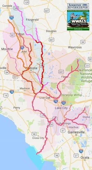 Click on this link for an interactive google map of the Suwannee River Basin.
The river traces come from USGS and Chris Graham. The watershed boundaries are from USGS. The springs are from the Florida Springs Institute, plus four Georgia springs collected by WWALS.
The eight-digit hydrologic unit codes (HUC8) for the Suwannee River Basin are: Continue reading
Does Cherry Creek come from Grand Bay? This question came up about Valdosta’s Cherry Creek Lift Station Spill. No, but you weren’t alone if you didn’t know that.
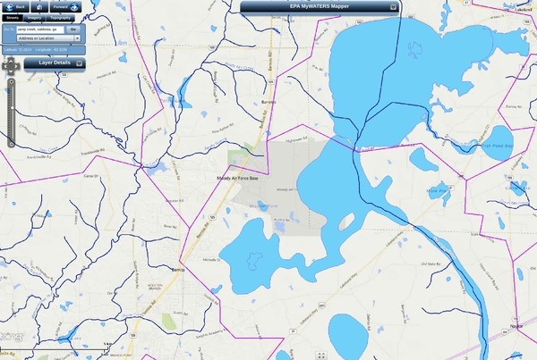
Cherry Creek (lower left) and Grand Bay Creek (right)
Cherry Creek runs into the Withlacoochee River, and comes from very near Grand Bay, but not Continue reading
Update 2017-01-25: And also a spill at the WWTP.
Nobody likes sewer spills, but no, these are not the same as before Valdosta’s
recent wastewater system improvements:

nothing this time came from the Withlacoochee Wastewater Treatment Plant,
and the amounts were small compared to previous years (10-62%)
and in far fewer locations.
That didn’t stop WTXL from using this title: Amber Lewis, WTXL, 24 January 2017, Major Sewage Spill Reported in Valdosta,
The City of Valdosta has reported that a large amount of untreated sewage has spilled in the area.
The Florida Department of Health reports that Continue reading
Here’s a
map of all rivers in the U.S. by Nelson Minar.
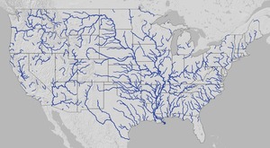 It actually covers the lower 48 states and is pretty impressive at that scale.
Plus you can zoom in.
It actually covers the lower 48 states and is pretty impressive at that scale.
Plus you can zoom in.
Here you can see rivers running to the Gulf start all the way up Continue reading
Spilling sewage into the Withlacoochee River apparently wasn’t enough
 for Valdosta: in February it also spilled three times into the
Alapaha River watershed.
At least once this was due to rains directly on Valdosta,
for which
the
levee proposed by the Army Corps of Engineers on Sugar Creek
at the Withlacoochee River wouldn’t help.
It’s time for Valdosta to move along with fixing its wastewater problems.
More transparency from Valdosta would also help.
And I, for one, would like to see that promised Corps flooding study
of the entire Suwannee River Basin.
for Valdosta: in February it also spilled three times into the
Alapaha River watershed.
At least once this was due to rains directly on Valdosta,
for which
the
levee proposed by the Army Corps of Engineers on Sugar Creek
at the Withlacoochee River wouldn’t help.
It’s time for Valdosta to move along with fixing its wastewater problems.
More transparency from Valdosta would also help.
And I, for one, would like to see that promised Corps flooding study
of the entire Suwannee River Basin.
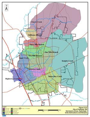
In three different reports in February, Valdosta mentioned sewage overflows into either Knights Creek or Dukes Bay Canal, without mentioning that those flow into Mud Swamp Creek, which joins with Grand Bay Creek to form the Alapahoochee River, which joins the Alapaha River, which flows into the Suwannee River. The Florida Department of Health apparently didn’t know that, since it didn’t mention the Alapaha River in its advisories for counties downstream. But Valdosta should know, according to its own SWMP Update Phase 1 Final Report, Section 2 Methodology, 2011-01-14, that about half of Valdosta is drained by Knights Creek and Dukes Bay Canal: Continue reading
 Proposed for the WWALS January 2014 outing:
the river most people know nothing about,
from the convergence of Mud Swamp Creek where Grand Bay Creek forms the border
between Lowndes County and Echols County in Georgia east of Valdosta,
about 14 miles through Echols County between Lake Park and Statenville,
to the Alapaha River in Hamilton County, Florida east of Jennings:
the Alapahoochee River.
Proposed for the WWALS January 2014 outing:
the river most people know nothing about,
from the convergence of Mud Swamp Creek where Grand Bay Creek forms the border
between Lowndes County and Echols County in Georgia east of Valdosta,
about 14 miles through Echols County between Lake Park and Statenville,
to the Alapaha River in Hamilton County, Florida east of Jennings:
the Alapahoochee River.
It has a waterfall, limestone caves, and boat ramps, all pictured by South Georgia Kayak Fishing 3 September 2011 in Alapahoochee convergence at Alapaha River – Jennings, FL.
 Here’s a brief day paddle description,
Florida whitewater, Alapahoochee River Grand Bay Canal),
by
riverfacts.com:
Here’s a brief day paddle description,
Florida whitewater, Alapahoochee River Grand Bay Canal),
by
riverfacts.com:
Echols / Hamilton county, GA SR 135 to FL SR 150 on Alapaha section whitewater kayaking, rafting, and paddling information.
This stretch of Alapahoochee River Grand Bay Canal) in Echols / Hamilton County is 4.5 miles long and is according to American Whitewater a class II section of whitewater.
They include a map.
