Tag Archives: Lowndes County

Drilling mud oozing up into the Withlacoochee River from Sabal Trail HDD

Update 2016-11-14: GWC Dirty Dozen Press Conference at US 84 Bridge with tour of Sabal Trail HDD 2016-11-16

Update 2016-11-13:Sabal Trail still leaking drilling mud into the Withlacoochee River at US 84 in GA 2016-11-12

FOR IMMEDIATE RELEASE

Hahira, GA, November 11th 2016 — 
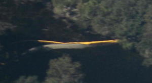
Sabal Trail leaked drilling mud up from their HDD pilot hole into the Withlacoochee River. Turbidity curtains and black pipe from the north bank 
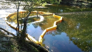
They knew this before WWALS asked two weeks ago what is that yellow thing in the river? They did not tell WWALS or the public that this thing they testified could not happen did happen. The evidence is in writing from Sabal Trail’s contractor to the Georgia Environmental Protection Division.

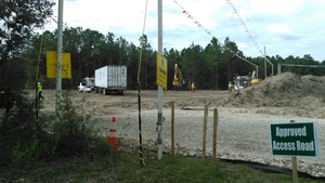
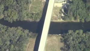
This wasn’t even the actual horizontal directional drilling (HDD) borehole: it was just the smaller pilot hole. What will happen to the Withlacoochee River (or nearby water wells) with the main borehole? What will happen to the Ochlockonee River west of Moultrie, GA? What will happen to the Santa Fe River, where Sabal Trail is drilling now, or the Suwannee River, where it will drill soon, both Outstanding Waters of Florida, supposed to have extra measures of environmental protection? What about the Tallapoosa, Chattahoochee, or the other Withlacoochee (south) River?

“Why should we accept any risk to our waters, or eminent domain to take our lands, for an unnecessary pipeline, now that Continue reading

Withlacoochee River with water @ GA 122, 2016-09-07

It does rain some times. Back in September at Hagan Bridge on GA 122 over the Withlacoochee River in Lowndes County, Georgia on the Withlacoochee and Little River Water Trail. The USGS gage at Skipper Bridge read 8 feet (128.5 NAVD).

-jsq

You can join this fun and work by becoming a WWALS member today!

Upstream 31.0135720, -83.3016070

Upstream

Downstream 31.0132885, -83.3015747

Continue reading

Non-answers in Sabal Trail Biweekly Status Report 2016-11-04

If drilling mud may be released, how can this also be? “No wastewater has been or will be dumped into the Withlacoochee River.” Sabal Trail seems to have contradicted itself. Sabal Trail responses to WWALS questions And didn’t answer the permit questions from WWALS. Nonetheless all their responses are marked “Resolution Date: 10/30/2016”. Nope, not resolved, Sabal Trail. See new questions.

Sabal Trail also said (see the PDF) it was completing drilling under the Flint River, was drilling under the Ochlockonee and Withlacoochee Rivers in Georgia, had just started under the Santa Fe River, was doing clearing and pad preparation for the Chattahoochee and Suwannee Rivers, and hadn’t yet started anything at the Withlacoochee (south) River in Florida. Plus quite a few complaints and questions, including some from FERC, and some archaeological discoveries which Sabal Trail and FERC hid under “Privileged and Confidential information”.

The Sabal Trail responses labeled Continue reading

Mozell Spells, Horn Bridge, GA-FL line, Withlacoochee River 2016-10-22

Movie: Horn Bridge, Mozell Spells, Withlacoochee River, GA-FL line (227K) Pictures and a movie clip from the air (thanks, Southwings!) of Mozell Spells, aka Madison Highway Boat Ramp, State Line Ramp (GA DNR) or GA 31 Ramp (SRWMD) or CR 145 Bridge Launch (FDEP).

This is one of two dozen public landings on the Withlacoochee and Little River Water Trail (WLRWT). It’s at the Georgia-Florida state line, and in the big picture (scroll down) you can see Continue reading

From the air: US 84 HDD Withlacoochee River Sabal Trail 2016-10-22

Update 2016-10-24: Questions filed with FERC in Docket CP15-17 as Accession Number 20161024-5049 and emailed to USACE and GA-EPD (PDF).

Extreme closeup yellow in Withlacoochee River, 30.7952780, -83.4524840 What is that yellow thing in the river, Sabal Trail? Is that a sinkhole you’ve marked at the Lowndes County HDD site? And does blue pipe mean thinner for rural areas like your executive from Houston told us in WWALS v Sabal Trail & FDEP?

FERC gave you permission to Continue reading

Withlacoochee Wastewater Treatment Plant old and new 2016-10-22

Old and New WWTP and landfill, 30.8212690, -83.3581890 Uphill and farther from the river: the new Withlacoochee Wastewater Treatment plant (top left of center) seen next to the old one, the Pecan Row Landfill, and the Withlacoochee River. Come ask your questions for the entire Suwannee River basin about wastewater and flood prevention this Thursday, October 27th 2016, at the Valdosta City Hall Annex. The $60 million in fixes so far and those still in progress are a big improvement for everybody downstream to the Gulf on the Withlacoochee, Alapaha, and Suwannee Rivers, and upstream on the Withlacoochee and Little River Water Trail. Continue reading

Okefenokee Suwannee River Outing @ Fargo, GA 2016-12-10

Update 2017-02-05 Pictures.

Okefenokee West Entrance Trails You can join WWALS for a fall Saturday paddle on the Suwannee River in the Okefenokee swamp. Bring a boat, PFD, and paddle, or you can rent those at the park.

When: 10AM Saturday December 10th 2016

Where: Georgia’s Stephen C. Foster State Park near Fargo, GA

What: Paddle from Billy’s Lake down through the River Narrows to the Suwannee River Sill.

Distance: About 7 miles in about 4 hours Continue reading

FSC Alignment Maps from May 2016

Small, big, huge, and PDF versions of each and every one of the 144 alignment maps FSC filed with FERC in May 2016 are available online courtesy of Lowndes Area Knowledge Exchange (LAKE).

[21040-510-ALS-00132 STA: 6250+00 TO 6300+00, MARTIN COUNTY, FLORIDA]
21040-510-ALS-00132 STA: 6250+00 TO 6300+00, MARTIN COUNTY, FLORIDA
PDF

The map shown here is where FSC crosses SW Martin Highway (FL 141) between Okeechobee City and Juno Beach, Florida. There will be a rally against this pipeline in Juno Beach at FPL HQ Friday and another in Okeechobee City Saturday.

Follow the link for details of what, and how you can help.

For maps of the rest of the Southeast Market Pipelines Project (SMPP), see SMPP.

-jsq

You can join this fun and work by becoming a WWALS member today!

Sabal Trail preparing to drill under Withlacoochee River in Georgia 2016-10-05

Update 2016-10-23: Aerial photography and videos: US 84 HDD Withlacoochee River Sabal Trail 2016-10-22: what is that yellow thing in the river, and is that round thing you’ve marked a sinkhole?

Approved Access Road, CAUTION, No Trespassing, 30.7873010, -83.4457610 Where would you guess Southeast Directional Drilling is based? Nope: Arizona. And the TRW truck has a Texas license plate. So much for local jobs where Sabal Trail is preparing to drill under the Withlacoochee River in Lowndes and Brooks Counties, Georgia, between Valdosta and Quitman.

Here is a playlist of WWALS videos, followed by a google map, and still pictures: Continue reading

Truck surveying at Withlacoochee River Lowndes County side

Follow this link for videos, more pictures, and a google map.