
The Suwannee River flows most in May, and most of that comes almost equally from
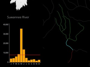 the Withlacoochee (with Little River and Okapilco Creek), the Alapaha, and the Suwannee from the Okefenokee Swamp to the Alapaha confluence.
This is an interestingly different seasonal pattern from other rivers of similar flow, such as the Altamaha, Savannah, St Johns, Flint, and Chattachoochee.
the Withlacoochee (with Little River and Okapilco Creek), the Alapaha, and the Suwannee from the Okefenokee Swamp to the Alapaha confluence.
This is an interestingly different seasonal pattern from other rivers of similar flow, such as the Altamaha, Savannah, St Johns, Flint, and Chattachoochee.
These are screenshots from the interactive ESRI Hydro Hierarchy, http://maps.esri.com/rc/radial/, whose Help message says: Continue reading


![[Project Location and Potential Pipeline Alignment]](https://www.wwals.net/pictures/2015-01-29--falling-creek-aquifer-recharge/50dcffe5ebd5ecaad9e46d02f682ec68.jpg)