Tag Archives: river

Pictures: Ichetucknee, Santa Fe Rivers 2020-01-20

The manatee swam under my boat; I was sitting still. This was on the Ichetucknee River, just above the Santa Fe River. Shirley Kokidko led us on the Redo: Ichetucknee and Sante Fe River Paddle 2020-01-20.

We’re going again January 2, 2021.

[Manatee under boat, 14:07:12, 29.9327060, -82.8000880]
Manatee under boat, 14:07:12, 29.9327060, -82.8000880

This is just a small selection of pictures. There are more here:
https://wwals.net/pictures/2020-01-20–ichetucknee-santa-fe-pictures

Click on any small picture to see a larger one. Continue reading

Troupville to Spook Bridge, Mayor’s Paddle, Withlacoochee River 2021-02-06

FOR IMMEDIATE RELEASE

Hahira, Georgia, November 12, 2020 — Join the Mayor of Valdosta and a hundred of his closest friends for a leisurely paddle on the Withlacoochee River. Mayor Scott James says, “Over a year removed from a terrible spill into our area waterways, and right at a year of massive improvements to our infrastructure since our last ‘Mayors Paddle,’ I am again looking forward to fellowship on the river February 6.”

All elected officials present will have three minutes to speak. And you can paddle up to them and ask questions.

WWALS President Tom H. Johnson Jr. said, “This stretch of river extends from the most populous city in the Suwannee River Basin past some suburbs and many rural woods. It is important for all the upstream city and county wastewater treatment plants to keep a grip on their sewage, because many people depend on the Withlacoochee River for swimming, fishing, and boating, plus water wells nearby may be affected by anything that goes into the river. It’s a joy that publicly elected officials are involved in this activity, and that the Mayor is helping organize it.”

It was fun last year, so let’s do it again! There is plenty of room to stay six feet apart, at Troupville Boat Ramp, the lunch stop, and at Spook Bridge, and of course on the water. We are still working out how the shuttle will work.

Suwannee Riverkeeper John S. Quarterman said, “Thanks again to The Langdale Company for riverside access at the mid-way lunch stop, and at the Spook Bridge takeout.”

[Pictures from last year]
Pictures from last year, 2020-01-18.

Attractions include Valdosta’s famous Withlacoochee Wastewater Treatment Plant (WWTP) Outfall, which has not spilled since December 2019. Yes, we know some people in the Valdosta city government consider that not a spill, since the raw sewage never actually got into the WWTP. We hope Valdosta’s new catch basin prevents that. Most of the route is downstream from GA 133, where Valdosta has frequently gotten high E. coli results from nobody yet knows what source. The entire route is upstream of Okapilco Creek, which sometimes carries cattle manure runoff after big rains. We will once again test the water quality from the river.

When: Gather 9 AM, launch 10 AM, end 4 PM, Saturday, February 6, 2021

Put In: Troupville Boat Ramp, 19664 Valdosta Hwy, Valdosta, GA 31602: on GA 133 off I-75 exit 18. in Lowndes County.

GPS: 30.851842, -83.346536

Take Out: Spook Bridge, west from Valdosta on US 84, left onto Ousley Road, right onto Old Quitman Highway, stop at the gate.
Thanks to The Langdale Company for access through their private property to Spook Bridge for this outing and for water quality testing.

Bring: the usual personal flotation device, boat, paddles, food, drinking water, warm clothes, and first aid kit. Also trash pickers and trash bags: every WWALS outing is also a cleanup.

Free: This outing is free to WWALS members, and $10 (ten dollars) for non-members. You can pay the $10 at the outing, or online:
https://wwals.net/donations/#outings

We recommend you support the work of WWALS by becoming a WWALS member today!
https://wwals.net/donations/#join

Event: facebook, meetup

[Troupville Boat Ramp (upper right) to Spook Bridge (lower left)]
Troupville Boat Ramp (upper right) to Spook Bridge (lower left) in the WWALS map of the Withlacoochee and Little River Water Trail.

Continue reading

The NFRWSP’s job is to figure out how to increase water levels in the aquifer. –Dennis J. Price 2016-12-12

This is a letter Practicing Geologist Dennis J. Price wrote for publication.

December 12, 2016

RE: North Florida Regional Water Supply Partnership

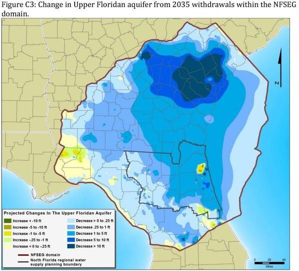
About 5 years ago, a report prepared for the Suwannee River Water Management District (SRWMD) indicated that under North Columbia County, East Hamilton County and Baker County, ground water levels in the Floridan aquifer (the aquifer the majority of us citizens get our water from) had dropped about 20 feet, more or less. The effects of the loss of that 20 feet was first felt and is very obvious in White Springs, 13 miles north of Lake City. The spring quit flowing for all intents and purposes. Tourism and the Towns economy plummeted.

[2019-04-03 White Sulfur Spring Flowing]
2019-04-03 White Sulfur Spring Flowing, so unusual an event it was reported for SRWMD by their Senior Hydrologist Fay Baird.

The report placed the greatest blame for the drawdown on water use by the coastal communities of South Georgia and North Florida. Scientists from the St. John’s River Water Management District (SJRWMD) at first concurred with this assessment. After objections from the Jacksonville Electric Authority (JEA) and the removal of several key employees at the SJRWMD, the SJRWMD said they weren’t sure anymore and a study needed to be done.

So, you guessed it, a committee was formed, The North Florida Regional Water Supply Partnership (NFRWSP). Don’t get me wrong regarding this committee, it is probably the single most important committee ever formed in our area. Their plans will affect the continued growth of North Florida communities along with the economy and recreational opportunities in our lakes and rivers.

Figure C3: Aquifer surface change due to withdrawals in north Florida and south Georgia

The NFRWSP’s job Continue reading

Letter: WWALS to FDEP and SRWMD: acquisitions, invitations, withdrawals, water quality testing 2020-11-10

Sent yesterday afternoon after the morning SRWMD board meeting.


November 10, 2020

To: Noah Valenstein
Secretary, FDEP
Noah.Valenstein@floridadep.gov

Hugh Thomas
Executive Director, SRWMD
Hugh.Thomas@srwmd.org

Sen. Keith Perry
Perry.Keith@flsenate.gov

Cc: Scott R. Koons
E.D., Rivers Task Force
koons@ncfrpc.org

Re: land acquisitions, event invitations, water withdrawals, and water quality testing

Dear Secretary Valenstein, Director Thomas, and Sen. Perry,

This morning I spoke via gotowebinar in the SRWMD Board Meeting. This letter expands on what I said.

[WWALS letter to FDEP and SRWMD]
WWALS letter to FDEP and SRWMD
PDF

I offered compliments, a suggestion, and a recommendation on the FDEP press release of yesterday: Continue reading

Trailmarker Tree Trails 2020-11-04

Second of a series of posts from Dr. Ken Sulak, USGS, retired. He is aware that Indian Trailmarker Trees are still speculative. Maybe with enough examples we can all determine whether they are what they seem to be. Please send pictures and locations of any trailmarker trees you may have seen, especially along old trails that crossed the Alapaha, Withlacoochee, Little, Suwannee, or Santa Fe Rivers, such as Old Coffee Road or various versions of El Camino Real.

[Old Trails]
Old Trails

Thanks for your reply. The trailmarker tree thing is an offshoot of my research on historic settler fords, ferries and bridges. Certainly early settlers traded with Seminoles and followed their trails. This Motte map is one of the few I have encountered that shows trails from GA coming into FL. There has also been more published on the ‘Alachua Trail’ figured in the next map. But that is of less interest to me because folks using that trail were primarily headed to the St. Johns River area—a distinct migration thing from the GA and SC folks headed for ‘Middle Florida’ where the best farm land and ample water was available.

I have been trying to confine my studies and field explorations to that area—but have inevitably gotten involved with what was happening in S GA. I have made several foot and solo kayak trips to the GA/FL border, and up into GA a bit now.

Many coming south from GA crossed into Spanish FL at Warners (Beauforts, Hornes) Ferry over the Withlacoochee, then headed south to Deadman’s Bay (Steinhatchee) to boil down salt water to make several barrels full of salt to take back to GA in wagons. This is one of the several ‘Old Salt Trails’ that later immigrant settlers used. All six of the so-far discovered trailmarker trees fall right on one of the dotted trails in this map

[1838 Motte Seminole War trail map]
Motte’s 1838 Seminole War map showing trails with dotted lines.

Warners Ferry or Horn’s Ferry was near where the current Horn Bridge is over the Withlacoochee River just upstream of State Line Boat Ramp and the GA-FL line.

I asked Ken a few questions, including: Continue reading

Horrid quality at GA 133 Friday, but good downstream and Saturday 2020-11-07

2020-11-13: Horrendous water quality at GA 133 & US 84 Wednesday, clean downstream 2020-11-12

Something bad got in the Withlacoochee River between US 41 and GA 133 on Friday: very bad, eleven times the Georgia Adopt-A-Stream alert limit for E. coli. But downstream water quality results by Valdosta Friday at US 84 and by WWALS down to the State Line show nothing unusual. Whatever it was maybe hadn’t gotten that far. Valdosta downstream results for Monday (today) and FDOH results for Tuesday may be interesting.

Once again, nothing at US 41 or GA 133 can be due to last Tuesday’s Tifton spill, because Tifton is on the Little River, and those places are on the Withlacoochee River upstream of the Little River Confluence.

So what caused those very bad GA 133 Valdosta results? It’s hard to avoid thinking somebody dumped into the river. When this phenomenon just started, rumor had it that GA-EPD had found the culprit, which was a private company. If so, there must be more than one, or whoever it was is back at it.

[Many locations]
Many locations

We also have Friday WWALS datapoints for Naylor Beach on the Alapaha River and for Royal Spring on the Suwannee River, both good. Continue reading

New Year Ichetucknee to Santa Fe River Paddle 2021-01-02

Reroute: Different entrance (South), different landing (Dampier’s), and upstream paddle.

First paddle of 2021, from Ichetucknee to Santa Fe Rivers.

Ichetucknee Springs State Park tells us no Ichy Nippy Dip Day for 2021, due to the virus pandemic, but the North Entrance will be open. So see you there, but keep your distance. Then WWALS will paddle downstream. We will also paddle past the notorious Sabal Trail fracked methane pipeline.

When: Gather 9:00 AM, Launch 10:30 AM, End 4:00 PM, Saturday, January 4, 2020

Put In: Ichetucknee S.P. North Entrance, 8294 SW Elim Church Rd, Fort White, FL 32038.

GPS: 29.9859, -82.7602

Take Out: Hwy 129 Boat Ramp, William Guy Lemmons Memorial Park Ramp @ 296th St. Ramp, From Branford, travel east on US 27; turn right on US 129; travel south to 296th Street; turn right and William Guy Lemons Memorial Park is on the left, in Suwannee County. 29.912717, -82.860514

Bring: the usual personal flotation device, boat paddles, food, drinking water, warm clothes, and first aid kit. Also trash pickers and trash bags: every WWALS outing is also a cleanup.

NOTE: The Ichetucknee is a non-disposable river; do not have any food or drinks in disposable packaging. All liquids and foods should be in reusable type containers. This helps keep litter out of our rivers.

Free: Free: This outing is free to WWALS members, and $10 (ten dollars) for non-members. You can pay at the event or online.
https://wwals.net/donations/#outings

We recommend you support the work of WWALS by becoming a WWALS member today!
https://wwals.net/donations/#join

Fee: There is a $5.00 park fee.

Event: facebook, meetup

[Start]
Start, 2020-01-20.

Continue reading

Accepted: WWALS FOIA to FERC on NFE Miami LNG export 2020-11-05

Update 2020-11-24: Extended two weeks: WWALS FOIA to FERC on NFE Miami LNG export 2020-11-23.

More than three weeks after we sent it, FERC acknowledged that the WWALS FOIA about the Miami LNG facility was “accepted” two weeks earlier, more than a week after we sent it.

We shall see whether the Federal Energy Regulatory Commission (FERC) has learned that Miami is not Puerto Rico. And whether FERC will follow the precedent it sent about Puerto Rico and send New Fortress Energy (NFE) a SHOW CAUSE Order for why NFE did not send a “Petition for Declaratory Orders” about the NFE Miami LNG facility. FERC has the power to shut down an LNG facility after the fact, for not following the law.

Meanwhile, FERC did not just refuse the FOIA request on its flimsy grounds of “non-jurisdiction.” See the WWALS FOIA request for more about that.

[FERC 404]
FERC 404
What you get if you follow the FOIA Public Liaison’s link to FERC’s FOIA request submission page.

Here is the “accepted” email: Continue reading

Odd water quality upstream, Withlacoochee River 2020-11-04

Update 2020-11-07: Horrid quality at GA 133 Friday, but good downstream and Saturday 2020-11-07

We don’t know what that contamination was upstream Wednesday on the Withlacoochee River at US 41 and GA 133. Rain didn’t cause it, because there was no rain.

We do know it was not the Tuesday Tifton spill, because that was into the Little River, which joins the Withlacoochee River downstream of GA 133.

We can speculate that whatever it was should be reaching the state line about now, or at least Knights Ferry. But we don’t know, because we have no downstream data: neither Valdosta nor Madison Health have reported anything below US 84 since last week, and our usual Thursday testers are out of commission this week.

[Chart and Map]
Chart and Map

So it’s hard to say what Withlacoochee River conditions might be right now.

[What's that?]
What’s that?
For context and the entire WWALS composite spreadsheet of Georgia and Florida results, see
https://wwals.net/issues/testing/

Maybe FDEP will report Withlacoochee River results in the morning.

Meanwhile, we did get good news for the Alapaha River Sunday, November 1, 2020, from WWALS tester Renee Kirkland: good quality at Sheboggy (US 82) and Statenville.

 -jsq, John S. Quarterman, Suwannee RIVERKEEPER®

You can join this fun and work by becoming a WWALS member today!

Twin Pines Minerals permit applications to GA-EPD

Here are four of the five active permit applications to GA-EPD from Twin Pines Minerals related to the proposed titanium mine far too close to the Okefenokee Swamp, which is the headwaters of the Suwannee and St. Marys Rivers, and interchanges water with the Floridan Aquifer, from which we all drink. Apparently there is also an air quality permit application. Since the Army Corps has abdicated oversight of this mine, you can ask the Georgia government to reject these permits.

[Page 2]
Page 2
Figure 75: Proposed Project Aquatic Feature Impact Areas Map –Twin Pines Minerals

Here is the relevant passage from GA-EPD’s responses to my open records request. I have interleaved links to where the files for each application are on the WWALS google drive.

Here is a summary of the permit applications in the GA EPD Watershed Protection Branch: Continue reading