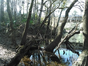
 A true survivor, a lone cypress tree in the middle of the Withlacoochee River.
Chris Mericle
A true survivor, a lone cypress tree in the middle of the Withlacoochee River.
Chris Mericle Withlacoochee River
A true survivor, a lone cypress tree in the middle of the Withlacoochee River.
Chris Mericle  A true survivor, a lone cypress tree in the middle of the Withlacoochee River.
Chris Mericle
A true survivor, a lone cypress tree in the middle of the Withlacoochee River.
Chris Mericle
The Lowndes County Commission is voting tonight on an easement for the Sabal Trail fracked methane pipeline through a mercury-contaminated closed landfill.
 They only gave one day’s notice, and they didn’t mention the landfill.
Here is the letter (PDF) I just sent them asking them to reject that easement,
to support their own previous unanimous resolution against Sabal Trail,
and to contact state and federal elected and appointed officials and ask them
also to reject Sabal Trail.
You can write them, too, to commissioner@lowndescounty.com.
They only gave one day’s notice, and they didn’t mention the landfill.
Here is the letter (PDF) I just sent them asking them to reject that easement,
to support their own previous unanimous resolution against Sabal Trail,
and to contact state and federal elected and appointed officials and ask them
also to reject Sabal Trail.
You can write them, too, to commissioner@lowndescounty.com.
To: Lowndes County Board of County Commissioners, Continue reading
 The flow from the Little River seemed to be much greater than the flow from the Withlacoochee River. Not very impressive at this water level.
Chris Mericle
The flow from the Little River seemed to be much greater than the flow from the Withlacoochee River. Not very impressive at this water level.
Chris Mericle Apparently fracked methane is Sierra Club Georgia’s next fight now that Keystone XL is dead, since almost its entire January/February/March issue of Georgia Sierran is about opposing natural gas: PDF.
See for example “Why Natural Gas Is Not a Climate Solution”, by Joshua Hanthorn. And “LNG Puts Savannah at Risk”, by Karen Grainey and Stacey Kronquest. Karen is chair of the Coastal Group of Sierra Club Georgia. Pretty much everything in that article also applies to Jacksonville, and quite likely to Palm Beach and other locations in Florida very soon.
Mentioning WWALS is “Pipeline in Southwest Georgia and Central Florida Risks Drinking Water,” by Gordon Rogers, Flint Riverkeeper,
The Sabal Pipeline, a joint venture of Spectra Energy, Duke Energy, and NextEra Energy, poses threats to Georgia and Florida communities on multiple fronts. For southwest Georgia and north Florida residents it’s all risks and no rewards. However, so far federal and state authorities have thus far been unmoved by arguments against it.
During the Federal Energy Regulatory Commission (FERC) public comment period, the agency received more than 1,000 written comments, mostly opposing the project, including resolutions against it from seven counties in Georgia and Florida, and three of the largest cities in its path (Albany, Moultrie and Valdosta).
The article talks about FERC’s FEIS, EPA, GA-EPD, and other matters, before turning to WWALS and Florida. Continue reading
Even the trend of sinking groundwater levels hasn’t changed a lot in the Georgia
parts of WWALS’ watersheds of the Withlacoochee, Alapaha, and upper Suwannee Rivers.
 Thanks to Tom Potter for the pointer, and we’re inviting someone to talk about this subject at the
Withlacoochee and Little River Water Trail Workshop at VSU February 27th, 2016.
Thanks to Tom Potter for the pointer, and we’re inviting someone to talk about this subject at the
Withlacoochee and Little River Water Trail Workshop at VSU February 27th, 2016.
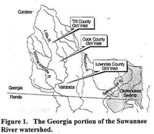
WATER RESOURCES OF THE UPPER SUWANNEE RIVER WATERSHED, by Mary M. Davis1 and David W. Hicks2,
1 Ecologist, Continue reading
Our rivers, creeks, swamps, lakes, and the Floridan Aquifer are part of that web of mutuality described on the north wall of the Martin Luther King Jr. Memorial in DC:
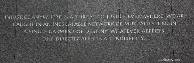
Injustice anywhere is a threat to justice everywhere.
We are caught in an inescapable network of mutuality,
tied in a single garment of destiny.
Whatever affects one directly affects all indirectly.
It was the Alabama River they sought to cross on the Edmund Pettus Bridge when John Lewis, Continue reading
 Here’s WWALS video of
the radio interview this morning on WVGA 105.9 FM.
It’s an invitation to tomorrow morning’s events, both at 10AM:
Here’s WWALS video of
the radio interview this morning on WVGA 105.9 FM.
It’s an invitation to tomorrow morning’s events, both at 10AM:
Chris also got me to say a few words about why WWALS formed in the first place, and why you should all join WWALS; it has to do with the 700-year flood in 2009.
Plus some plugs for Valdosta’s wastewater fixes and their recent LiDAR flight.
The one thing I realized on the way out I forgot to mention, the one item that caused me to schedule this interview, was the workshop at VSU February 27th about the Withlacoochee and Little River Water Trail, featuring the visual beauty of all WWALS’ rivers in an art exhibit and silent auction, the geology on display by Dennis Price, and the remains of past people and cultures still visible along the river by Tom Baird.
Looking forward to seeing you tomorrow morning on the Little River, or other WWALS members look forward to seeing you tomorrow morning on the Suwannee River. If not tomorrow, there’s plenty more to do on our beautiful south Georgia and north Florida blackwater rivers!
Here’s the video:
Continue reading
Everybody listens to the radio in the car on the way to work,
![]() and Friday morning 8:30 AM I’ll be talking about
paddling this Saturday morning 10AM on the Little River from GA 122 between Hahira and Barney to Lawson Millpond Road; it’s a nice brief 2.5 hour paddle along the Brooks-Lowndes County river border: you can do it!
and Friday morning 8:30 AM I’ll be talking about
paddling this Saturday morning 10AM on the Little River from GA 122 between Hahira and Barney to Lawson Millpond Road; it’s a nice brief 2.5 hour paddle along the Brooks-Lowndes County river border: you can do it!
When: 7:30AM Friday January 15th 2016
Where: 105.9 FM WVGA, Valdosta, Lowndes County, Georgia
What: John S. Quarterman, president of WWALS Watershed Coalition, Inc., on Chris Beckham drive-time radio show
How: Continue reading
Update 2016-03-24: Pictures.
Explore the Withlacoochee River as it meanders thru the edge of Valdosta,
past
Shadrick Sink,
Cherry Creek, and
under
North Valdosta Road,
 on the
Withlacoochee and Little River Water Trail.
Wave at some of your friends in the houses nearby.
on the
Withlacoochee and Little River Water Trail.
Wave at some of your friends in the houses nearby.
Update 2016-03-19: Yes, there are potholes at Staten Road Bridge, but that never stopped us from paddling. Come on down!
Update 2016-03-14: Langdale Park will be closed, but VLPRA will let us in.
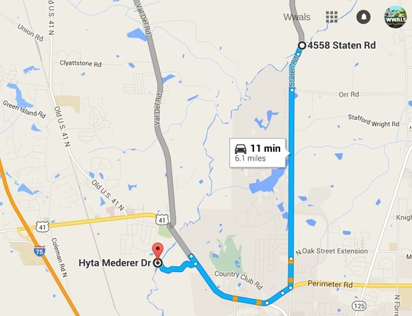
When: 9AM Sunday March 20th 2016
Put in: Staten Road Bridge, 7.1 miles north of Valdosta, Lowndes County.
Take out: Langdale Park Boat Ramp, 3781 N. Valdosta Rd., Valdosta, GA 31602, Lowndes County.
Distance: About 5 miles
Duration: About 2.5 hours
Shuttle: About half an hour
Take out: Langdale Park Boat Ramp
Also passing: Bay Branch, Sermons Branch (if that is its real name), Withlacoochee Slough at Cherry Creek, Cherry Creek Sink, and Stillhouse Branch coming out of Valdosta Country Club.
Responsible party: Chris Mericle
Local host: John S. Quarterman
Directions from Valdosta: head north on Ashley Street, turn left on Oak Street Extension,
Directions from I-75: take exit 22, go east on North Valdosta Road, left on Perimeter Road, left on Oak Street, continue onto Staten Road, cross Orr Road, and after about 2/3 of a mile just before the bridge, turn off to the right.
Too low: we’re guessing 2 feet on either the at Skipper Bridge or US 41 gauges.
Too high: flood stage is 15 feet at Skipper Bridge and at US 41.
This outing is Free! But we encourage you to join WWALS today to support our fun outings and important work: /donations/. See our newsletters, and the press Releases and news. And consider joining the Withlacoochee and Little River Water Trail Committee.
Where: Ray’s Millpond
When: 9AM March 20th 2016
Directions: From Valdosta, north on Bemis Road (GA 125) to Ray City, right on Jones St. to boat ramp.
Coming up even sooner:
For more outings and events as they are posted, see the WWALS calendar.
-jsq
You can join this fun and work by becoming a WWALS member today!
Valdosta has a water treatment byproduct over the recommended limit in its drinking water. Janet McMahan supplied the image below of part of a notice, which says there’s no cause for alarm at the moment:

There is nothing you need do at this time. These violations do not pose Continue reading