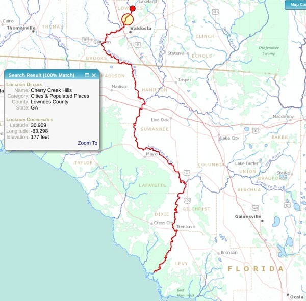
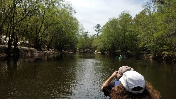
Category Archives: Blueway

Old Coffee Road across Alapaha River

Many of you know Julian Fields, retired forester, very knowledgable about many things around south Georgia. In this video, he’s showing people where Old Coffee Road forded the Alapaha River. I haven’t been able to find a map of any age that shows that ford. However, given that Old Coffee Road in Berrien County goes as far as Rowetown Church Road, I’d guess either Rowetown Church Road is where Old Coffee Road crossed the river, at Rowetown Church Cemetery, or it was somewhat upstream. Does anybody know?

Julian Fields

Or I suppose I could just ask Julian. Here’s the video: Continue reading

WMA in Lanier and Lowndes Counties

Yes, it’s a WMA on both sides of the Alapaha River, and it will open for hunting this year. It’s also one of seven or eight, all also Dr. Acree’s land. They will each have names, which are currently unknown, but will pop up in the next few days on the DNR website.

Floating downstream
Photo: John S. Quarterman, 2 April 2017, in Alapaha River, Hotchkiss Road to US 84 2017-04-02

This WMA information is from someone who’s been on site and knows the details, Continue reading

Alapaha River, Hotchkiss Road to US 84 2017-04-02

This was a tiny outing for a couple of visitors from Oregon through what has since become a new Wildlife Management Area on the Alapaha River, between Hotchkiss Road (which had some magnificent potholes) in Lanier County to the site of the pending new park and boat ramp off of US 84 in Lowndes County, Georgia, all on the Alapaha River Water Trail.

Suwannee Riverkeeper banner on the Alapaha River

The visitors were Continue reading

Naylor Boat Ramp and Sheboggy Landing, Alapaha River

The Lowndes County parcel in the new Wildlife Management Area off of US 84 does not go as far north as the Lanier County one, and does not go all the way to the Alapaha River at US 84:

Lowndes County between US 84 almost to Old State Road
Lowndes County parcel 0259 030A from US 84 almost to Old State Road

This is because some years ago Continue reading

WMA signs in Lanier County, Alapaha River

Christopher Graham reports: “These signs are everywhere on Hotchkiss Road on the Lanier side of the Alapaha River.”

Boundary Wildlife Management Area
Boundary Wildlife Management Area; Photo: Christopher Graham, 29 July 2017

Please note this is not the Alapaha River Wildlife Management Area off of US 319 between Tifton and Ocilla. That Alapaha River WMA is way upstream of the top of the Alapaha River Water Trail (ARWT), although it is on the ARWT map.

These new WMA signs are in the middle of the ARWT on this 266 acres in Lanier County parcel Continue reading

Nankin Landing to Madison Highway: Withlacoochee River 2017-10-14

Back by popular request, 9.1 miles past two of the six second-magnitude springs in Georgia, into and back out of Florida, over numerous shoals, on the tea-colored Withlacoochee River in the fall, all on the Withlacoochee and Little River Water Trail.

When: 9AM Saturday, October 14, 2017

Put In: Nankin Boat Ramp, MILE 36.3, 6899 Clyattville-Nankin Rd, Valdosta, GA 31601, in Lowndes County.

GPS: 30.675192, -83.394143

WWALS banner at McIntyre Spring

Bring: the usual personal flotation device, water, snacks, trash bag, and trash picker: every WWALS outing is also a cleanup! If you do not have a boat, let us know, and probably somebody can loan you one, or contact one of the many outfitters.

Free: This outing is Free! And we recommend you support the work of WWALS by becoming a WWALS member today!

Event: facebook, meetup.

Take Out: Madison Highway Boat Ramp, MILE Continue reading

Rivers Alive Cleanup and Paddle Outing, Alapaha River 2017-09-10

Update 2017-09-25: Rescheduled for October 1, 2017.

Update 2017-09-08: Canceled due to Hurricane Irma.

A combination Rivers Alive and Waterkeeper Alliance Cleanup on the enchanting Alapaha River at Pafford Landing, Lakeland, Georgia, plus optional upstream and back paddle afterwards.

When: 2PM, Sunday, September 10, 2017

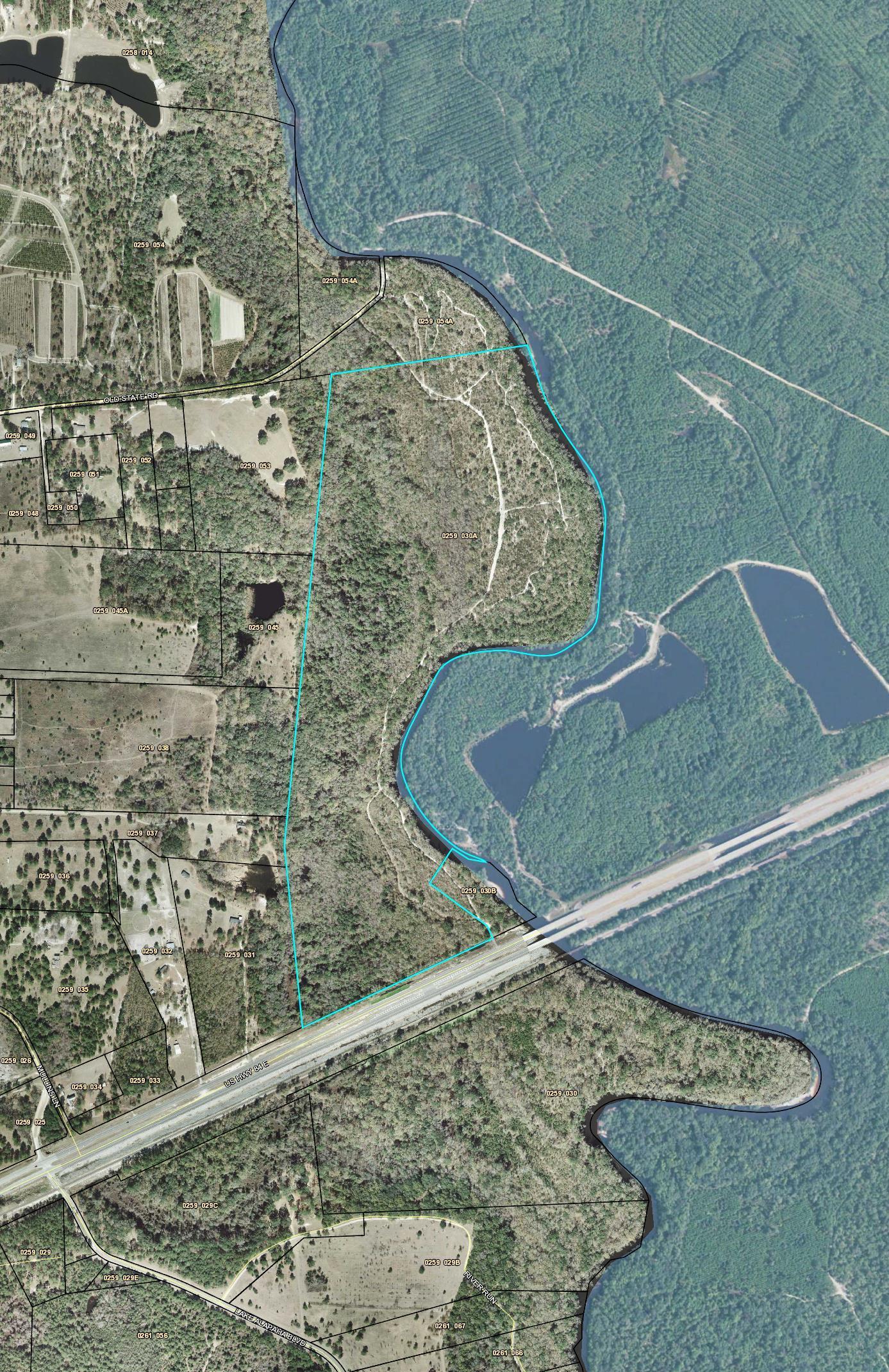
Where: Pafford’s Landing, MILE 71.73, east of Lakeland, south side of GA 122, into the woods, west side of Alapaha River, Lanier County
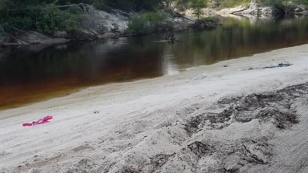
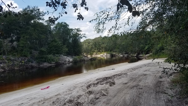
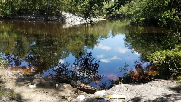
, Georgia.

GPS: 31.043011, -83.042564

Pafford's Landing map

Event: facebook, meetup.

Cleanup: Cleanup materials will be provided, but if you’ve got a trash picker, bring it along.

Paddle: You do not have to bring a boat, and you do not have to paddle. If you do paddle, bring the usual personal flotation device, water, snacks, etc.

Free: This outing is Free! And we recommend you support the work of WWALS by becoming a WWALS member today!

Host and Contact: Continue reading

Pictures: Banks Lake Full Moon Paddle 2017-07-08

Lights! Full Moon! Paint! Rice and watermelon! Fun was had by all last Saturday on the WWALS watery living room, Banks Lake, just west of Lakeland, GA on GA 122.

Only saw one gator, and he got scared away by all the boats. Didn’t see any moccassins, but I bet they were there in the lily pads on the west side across the lake, where we turned back.

Paddlers with WWALS and Suwannee Riverkeeper Banners, 31.0351925, -83.0965187

The total I think was seventeen paddlers in sixteen boats, some not pictured here due to not arrived yet, or something.

Paddlers with WWALS and Suwannee Riverkeeper Banners,

Movie: Tom Cramer and his wife Barb are the volunteers at Banks Lake Outdoors (26M)

Continue reading

Paddle races, songwriting contest, water trails, and advocacy at WWALS Board Meeting 2017-07-12

Draft Agenda
WWALS Quarterly Board Meeting
7:30 PM Wednesday 12 July 2017, After Annual WWALS Membership Meeting
Wooden Nickel, 3269 Inner Perimeter Rd, Valdosta, GA 31602
Dial-in Number: (641) 715-3580
Meeting ID: 855-676
Event: facebook

Election of officers, paddle races, songwriting contest, festivals, water trails, and more.

[Under the cypress]
Under the cypress, in the BIG Little River Paddle Race

All WWALS members, especially committee members, are invited to attend, as is the general public.

All WWALS Board Members are expected Continue reading

Hardee Spring and Plantation, Withlacoochee River, Hamilton County, FL

Yes, Hardee Spring is accessible by land, off of 34th Street NW, Jennings, Florida, aka Hardee Camp Road, but it’s on private land. It’s on one of four parcels totaling 305 acres, with 8,000 feet (1.6 miles) of river frontage and a lodge, which can be yours for a mere $8.5 million. Maybe Suwannee River Water Management District (SRWMD) should buy it, since SRWMD already owns the next properties upstream and downstream on the Withlacoochee River. Or maybe it should be turned into a state park. Or maybe somebody wants to donate it to WWALS for an office location.

Map: River Error Farms Inc., Hardee Spring, Hamilton County, FL
Map from SRWMD PARCEL ASSESSMENT SUMMARY.

Continue reading