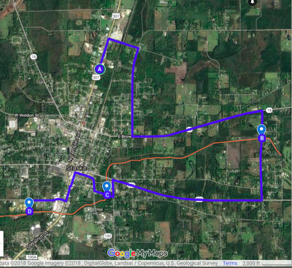
Tag Archives: Alligator Creek

SRWMD Board in Starke 2018-12-11

Deviating from its usual practice of meeting in Live Oak, it’s going to Starke, the Suwannee River Water Management District (SRWMD) Board, Tuesday of next week, 9AM December 11, 2018, at the Governor Charley Johns Conference Center, 1610 N. Temple Avenue, Starke, FL.

I don’t see anything on the agenda especially about Bradford County, except tacked onto the end as open to the public “Following Board Meeting”: “• Projects Tour in Starke”.

I’m guessing that refers to the tree clearing project approved as an emergency several months ago, at the request of the Bradford BOCC, due to expected rains.

According to Kevin Flavin, Project Manager and Professional Water Resources Engineer,

Projects, Tour
Follow this link for an interactive google map by WWALS.

Two stops are to Continue reading

Bradford BOCC 2018-09-04

All the public speakers were against the phosphate mine. Before the Commissioners decided, Merrillee Malwitz-Jipson spoke about rain, the Chemours mine, and how what Bradford County does affects her business downstream. (I think Stasia Rudolph also spoke before I got there.) After some confusion on timing, afterwards Marc Lyons reminded them Citizens Against Phosphate Mines (CAPM) is ready to sue, and Kate Ellison said she hopes this means we will all see the consultant’s report before the public hearings. I sent a letter and a resolution the previous day and gave them paper copies.

The actual decision was much better than expected. While some Commissioners wanted to hold Continue reading

Suwannee River Basin Maps

Update 2019-02-13: And a version with Landings. See also Water Trails, with more detailed maps and access points.

Nobody seems to have done this, so we did: a map of the Suwannee River Basin, with the major watersheds and the Estuary shaded, and all the major rivers, plus many of the creeks. Bonus: springs! Narrow, Suwannee River Basin Click on this link for an interactive google map of the Suwannee River Basin.

The river traces come from USGS and Chris Graham. The watershed boundaries are from USGS. The springs are from the Florida Springs Institute, plus four Georgia springs collected by WWALS.

The eight-digit hydrologic unit codes (HUC8) for the Suwannee River Basin are: Continue reading

Rivers Seven Days After Irma 2017-09-17

Looks like we may finally see Action stage tomorrow on the Withlacoochee River above Valdosta @ Skipper Bridge Road. This is upstream from Valdosta’s Withlacoochee Wastewater Treatment Plant, so it’s a good thing that didn’t spill during Irma. The Alapaha River at Statenville peaked Tuesday and probably would be a fine ride (what shoals?) today. The New and The Santa Fe Rivers are still flooding, and that’s still raising the Suwannee River all the way to the Gulf, and there’s minor flooding all the way up at Fargo, so another surge of high levels may follow on the Suwannee. The I-75 Santa Fe River bridge never did close.

2017-09-17 Withlacoochee River above Valdosta @ Skipper Bridge Road

The Suwannee River at White Springs peaked Continue reading

River Gage Projections after Hurricane Irma 2017-09-14

Update 2017-09-15: On the seventh day.

Update 2017-09-15: Added Suwannee River at Wilcox @ US 19, plus another image for the Gage Map.

Hurricane Irma flooded the Suwannee River at White Springs, the Santa Fe River especially at Fort White, with a new record for the New River new Lake Butler. It did not flood the Withlacoochee or Alapaha Rivers.

N2017-09-14 Suwannee River at White Springs
2017-09-14 Suwannee River at White Springs

FDOT says the I-75 bridge over the Santa Fe River Continue reading

River Gage Projections for Hurricane Irma 2017-09-10

Update 2017-09-15: On the seventh day.

Hurricane Irma is bringing flood levels on on most of the rivers in the Suwannee River Basin. Here are the gages with projections from downstream to upstream, since Irma is coming from the south. The images here are static to show this moment, but click on any image to go through to the live gage.

Suwannee River

Suwannee River at Fowlers Bluff

Suwannee River at Fowlers Bluff

Suwannee River at Branford @ US 27

Continue reading