Tag Archives: Brooks County

Record-holding farmer, land destroyed by Sabal Trail, in Valdosta at pipeline safety meeting

FOR IMMEDIATE RELEASE

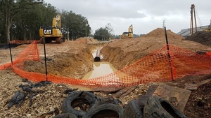
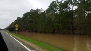
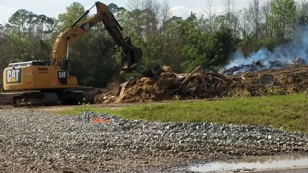
Valdosta, May 3, 2017 — U.S. corn production record holder and world soybean record holder Randy Dowdy, whose record-producing fields were severely eroded in rains after Sabal Trail’s pipeline construction destroyed his terraces and caused massive erosion of his cropland, will be at the Rainwater Conference Center in Valdosta 11:30 AM this morning at a pipeline safety exercise to talk about the implications of Sabal Trail’s destruction for pipeline safety and his livelihood.

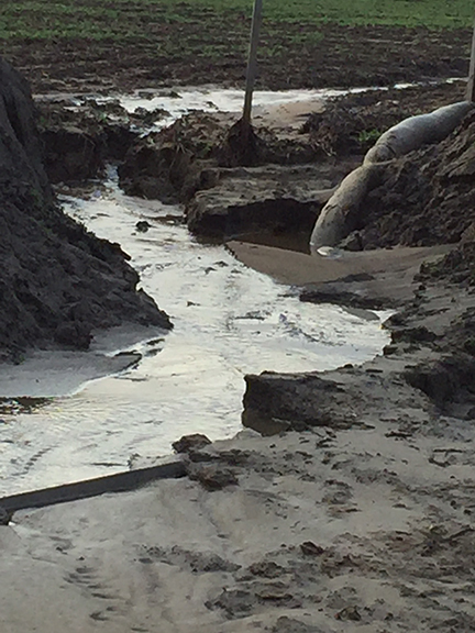
Randy Dowdy is the 2014 50-year record holder for U.S. corn production and the world record holder for soybean production. Sabal Trail gouged its pipeline through his terraces on the land he used for those soybeans in Brooks County. Despite his warnings, they left that damage unfixed until rains in January caused massive erosion, washing his topsoil into a nearby creek. Beyond immediate damage, this destruction affects Dowdy’s ability to grow such record yields, and the basic productivity of his fields. What further economic damage has Sabal Trail done to other farmers and landowners? Where else will Sabal Trail’s pipeline cause erosion, perhaps in some places exposing the pipe and risking corrosion and breaks?

The event 11:30 AM this morning at Rainwater Conference Center in Continue reading

Chicken hatchery coming to Quitman, GA

Update 2017-05-06: More on ownership of Aviagen.

In Brooks County south of Quitman, draining into Piscola Creek and the Withlacoochee River, in the same industrial park where WWALS caught Sabal Trail illegally burning, a poultry breeder will be setting up shop.

News Desk, Area Development, 9 March 2017, Aviagen Plans $18 Million Hatchery In Quitman, Georgia,

Aviagen, a leading broiler breeding company, will create 100 jobs and invest approximately $18 million in a new parent stock hatchery at Brooks County Industrial Park, 17 miles west of Valdosta, in Quitman, Georgia.

The Quitman facility will be Aviagen’s eighth Continue reading

Brooks County, Springs Capital of Georgia

Brooks County can boast three springs of a type usually thought to be only in Florida. Of only about six second magnitude springs in Georgia, three are downstream from US 84: Wade or Blue Springs, sadly defunct; McIntyre Spring, large and easily accessible in the right bank emerging from 4610 feet of caverns back under Brooks County; and Arnold Springs, actually three small springs in the left bank.

Movie: Swimming at McIntyre Spring (1.5M)
Picture by John S. Quarterman for WWALS Watershed Coalition 9 July 2016,
as are all the other pictures herein not otherwise labeled.

And there are numerous shoals between these springs.

Springs

Continue reading

Sabal Trail burning, water, and pipe in Brooks and Lowndes Counties, GA 2017-03-08

Update 2017-03-10: PDF of burning and water well drilling violation complaint sent to FERC, USACE, GA-EPD, and GFC.

Bringing materials from another site to burn is illegal in Georgia, even if they had a permit, which they didn’t, it couldn’t cover open burning of treated ties like Sabal Trail is doing at the Brooks County Industrial Park south of Quitman, Georgia. Georgia Forestry Commission is already on it, and I’m alerting FERC, USACE, GA-EPD, and Brooks County today. The entire Troy yard is right next to a wetland, with three drainage ditches crossing the site.

Carries tie

There’s nothing going on at the Withlacoochee River HDD site in Lowndes County, but they’re shuffling pipe on a Texas Troy truck between Gary Lane Knights Ferry Road, right past a Lowndes County School bus on McGoggle Road. Continue reading

Pictures, McIntyre and Arnold Springs, Nankin to Madison Hwy, Withlacoochee River 2016-07-09

Update 2024-02-29: Now with better picture format.

We found McIntyre Spring, and Arnold Springs, too, on the WWALS Withlacoochee River Outing from Nankin Boat Ramp to Madison Highway Boat Ramp, July 9th 2016. Swimming, snorkeling, karst, shoals, an abandoned railroad trestle, more shoals, State Line Shoals, old road bridge posts, dragonflies, and Halberdleaf rosemallow (Hibiscus laevis All.), unfortunately plus Chamber bitter.

[McIntyre Spring and State Line Shoals 2016-07-09]
McIntyre Spring and State Line Shoals 2016-07-09

Update 2017-05-13: On 2016-07-09, the US 84 Quitman gage showed about 1.75 feet (85.26 NAVD), and the Pinetta gage showed about 6.57 (53.08 NAVD). That’s a foot lower than June 22, 2013, when we thought that was already as low as you’d want to paddle.

Here are a few videos, some pictures, and a google map showing where the pictures were taken.

 -jsq, John S. Quarterman, Suwannee RIVERKEEPER®

You can help with clean, swimmable, fishable, drinkable, water in the 10,000-square-mile Suwannee River Basin in Florida and Georgia by becoming a WWALS member today!
https://wwals.net/donations/

Videos

Here is a playlist of WWALS videos:
https://www.youtube.com/playlist?list=PLKwQ5xfKf-Qyed6eWPp4xcYNjZI-NMW-j Continue reading

Brooks County Comprehensive Plan Workshop

More about that in a previous post.

 -jsq, John S. Quarterman, Suwannee RIVERKEEPER®

You can join this fun and work by becoming a WWALS member today!

Sabal Trail still wallowing in water, GA 76 between Morven and Quitman, GA

Looks like they already bored under the road with their red pipe, but can it be good for the pipe to be sitting in water? And after they cover it over with dirt, will it still be low enough to be in the water table?

 -jsq, John S. Quarterman, Suwannee RIVERKEEPER®

You can join this fun and work by becoming a WWALS member today!

Workshop, Greater Brooks 2030 Comprehensive Plan, 2017-02-07

First on the list of Areas Requiring Special Attention in Brooks County, Georgia:

  • Areas of significant natural or cultural resources, particularly where they are likely to be intruded upon or otherwise impacted by development; such as wetlands, groundwater recharge areas and river corridors.

/pictures/2007-01-01--brooks-compplan/[Map D-4 Water Resource Protection Districts]
Map D-4 Water Resource Protection Districts

According to Ariel Godwin of the Southern Georgia Regional Commission,

The next workshop for the Brooks County Comprehensive Plan will be:

Thursday, February 7th, 2017
9:30 a.m
Brooks County Commission Offices
610 South Highland Street, Quitman

In this workshop we will work on the Land Use Maps and Character Areas.

We are inviting you to participate to ensure Continue reading

Sabal Trail erosion and waterlogged, Brooks County, GA 2017-01-23

End of pipe in water, CR 146, towards Tallokas Road 30.9873162, -83.6535762 Is that pipe supposed to be wallowing in water? Is that end supposed to be in the water? What about the obvious erosion? Remember Sabal Trail is only burying its 36-inch pipe 36-inches deep most places. Erosion could expose it and make it even more likely to corrode.

WWALS video playlist and more pictures below. Continue reading

Okapilco Creek flooding @ GA 122 2017-01-23

Narrow Bridge 30.9955325, -83.6041529 Half a mile wide: Okapilco Creek one week ago on GA 122 between Barney and Pavo, Georgia.

Usually you have to peer down into the woods to see if you can see any water in the creek. After the recent storms, you could see water beside the highway half a mile before you got to the creek bridge.

WWALS video: Continue reading