City Council Tim Carroll forwarded me the appended press release yesterday. I assumed it would be on Valdosta’s News page, but it is not.
Also, despite assurances back in January that Continue reading

City Council Tim Carroll forwarded me the appended press release yesterday. I assumed it would be on Valdosta’s News page, but it is not.
Also, despite assurances back in January that Continue reading
Why should anyone downstream care about an obscure creek north of Valdosta? Because it runs past sinkholes that leak into the Floridan Aquifer, into the Withlacoochee River, then into the Suwannee River, then into the Gulf of Mexico, going by all seven of the downstream Florida counties that passed resolutions asking the state of Florida to do something about Valdosta wastewater, not to mention neighborhoods and wetlands closer to the recent Cherry Creek Lift Station sewage leak, which was at least smaller than previous spills.
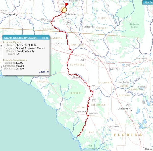
The orange red-circled disk shows Continue reading
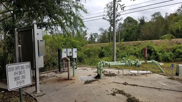
Does Cherry Creek come from Grand Bay? This question came up about Valdosta’s Cherry Creek Lift Station Spill. No, but you weren’t alone if you didn’t know that.
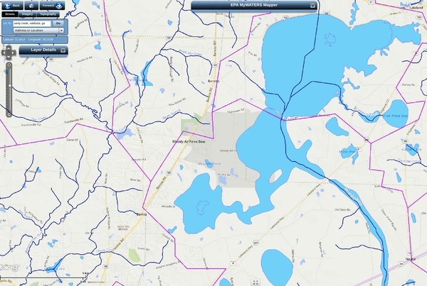
Cherry Creek (lower left) and Grand Bay Creek (right)
Cherry Creek runs into the Withlacoochee River, and comes from very near Grand Bay, but not Continue reading
Valdosta had one spill at a lift station that lost power during Tropical Storm Irma, said David Frost, Interim Utilities Director, City of Valdosta, when I called him just now. I asked him if there were any others, and he said there was just that one.
He said it was a small spill. I asked how small. He said Continue reading
Update 2016-03-24: Pictures.
Explore the Withlacoochee River as it meanders thru the edge of Valdosta,
past
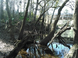
Shadrick Sink,
Cherry Creek, and
under
North Valdosta Road,
 on the
Withlacoochee and Little River Water Trail.
Wave at some of your friends in the houses nearby.
on the
Withlacoochee and Little River Water Trail.
Wave at some of your friends in the houses nearby.
Update 2016-03-19: Yes, there are potholes at Staten Road Bridge, but that never stopped us from paddling. Come on down!
Update 2016-03-14: Langdale Park will be closed, but VLPRA will let us in.
When: 9AM Sunday March 20th 2016
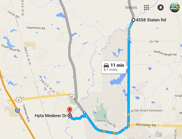
Put in: Staten Road Bridge, 7.1 miles north of Valdosta, Lowndes County.
Take out: Langdale Park Boat Ramp, 3781 N. Valdosta Rd., Valdosta, GA 31602, Lowndes County.
Distance: About 5 miles
Duration: About 2.5 hours
Shuttle: About half an hour
Take out: Langdale Park Boat Ramp
Also passing: Bay Branch, Sermons Branch (if that is its real name), Withlacoochee Slough at Cherry Creek, Cherry Creek Sink, and Stillhouse Branch coming out of Valdosta Country Club.
Responsible party: Chris Mericle
Local host: John S. Quarterman
Directions from Valdosta: head north on Ashley Street, turn left on Oak Street Extension,
Directions from I-75: take exit 22, go east on North Valdosta Road, left on Perimeter Road, left on Oak Street, continue onto Staten Road, cross Orr Road, and after about 2/3 of a mile just before the bridge, turn off to the right.
Too low: we’re guessing 2 feet on either the at Skipper Bridge or US 41 gauges.
Too high: flood stage is 15 feet at Skipper Bridge and at US 41.
This outing is Free! But we encourage you to join WWALS today to support our fun outings and important work: /donations/. See our newsletters, and the press Releases and news. And consider joining the Withlacoochee and Little River Water Trail Committee.
Where: Ray’s Millpond
When: 9AM March 20th 2016
Directions: From Valdosta, north on Bemis Road (GA 125) to Ray City, right on Jones St. to boat ramp.
Coming up even sooner:
For more outings and events as they are posted, see the WWALS calendar.
-jsq
You can join this fun and work by becoming a WWALS member today!
Update 2017-09-13: The Lowndes County Commissioners surprisingly agreed to rezone “backwards” to Estate A gricultural (E-A) at their Regular Session of 14 April 2015.
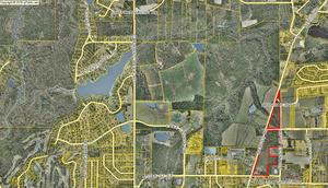 A historic dairy farm wants to go back to the most agricultural zoning,
upstream on Cherry Creek from the
Cherry Creek Sink that leaks into the
Floridan Aquifer.
Vallotton Farms (both the part outlined in red
that appears to be the subject of the rezoning and the bigger part west of Bemiss Road) includes quite a bit of Cherry Creek itself.
Agriculture is probably better than other likely uses in such a location. Continue reading
A historic dairy farm wants to go back to the most agricultural zoning,
upstream on Cherry Creek from the
Cherry Creek Sink that leaks into the
Floridan Aquifer.
Vallotton Farms (both the part outlined in red
that appears to be the subject of the rezoning and the bigger part west of Bemiss Road) includes quite a bit of Cherry Creek itself.
Agriculture is probably better than other likely uses in such a location. Continue reading
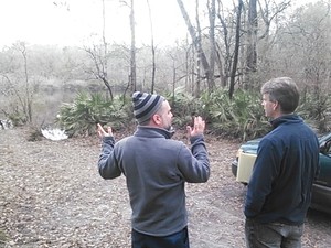 Yesterday Prof. Don Thieme, WWALS member Dan Coleman, and I showed
a reporter around some sinkholes near the Withlacoochee River,
including one that’s been there for decades, leaking into the
Floridan Aquifer, and one that opened up within a couple of months
only a few years ago.
Yesterday Prof. Don Thieme, WWALS member Dan Coleman, and I showed
a reporter around some sinkholes near the Withlacoochee River,
including one that’s been there for decades, leaking into the
Floridan Aquifer, and one that opened up within a couple of months
only a few years ago.
Dan Coleman says Shadrick Sinkhole has been there probably at least Continue reading
Drilling through fragile sinkhole-prone
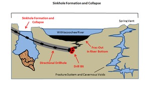 karst limestone under the Withlacoochee River (or the Suwannee River,
or the Santa Fe River): what could possibly go wrong?
Sabal Trail now proposes to move off of the Withlacoochee River in
Florida, but still plans to cross the Withlacoochee in Georgia,
and to cross the Suwannee and Santa Fe Rivers, all of which have
the same hydrogeology.
You can talk directly to Sabal Trail and FERC at the
Open House in Jasper, Florida, 5-7PM Tuesday 21 October 2014,
and you can join WWALS where the Alapaha River
disappears entirely into a sinkhole,
at the
Alapaha Sink, 2PM Sunday 26 October 2014.
karst limestone under the Withlacoochee River (or the Suwannee River,
or the Santa Fe River): what could possibly go wrong?
Sabal Trail now proposes to move off of the Withlacoochee River in
Florida, but still plans to cross the Withlacoochee in Georgia,
and to cross the Suwannee and Santa Fe Rivers, all of which have
the same hydrogeology.
You can talk directly to Sabal Trail and FERC at the
Open House in Jasper, Florida, 5-7PM Tuesday 21 October 2014,
and you can join WWALS where the Alapaha River
disappears entirely into a sinkhole,
at the
Alapaha Sink, 2PM Sunday 26 October 2014.
Here are before and after diagrams by Continue reading
