
 A nice day for a paddle upstream, in these pictures and videos by Gretchen Quarterman
of the
18 January 2014 WWALS Outing at the Statenville Boat Ramp on the Alapaha River. Continue reading
A nice day for a paddle upstream, in these pictures and videos by Gretchen Quarterman
of the
18 January 2014 WWALS Outing at the Statenville Boat Ramp on the Alapaha River. Continue reading
Tag Archives: Echols County
Statenville to Sasser Landing on the Alapaha River, WWALS Outing, 2015-02-15
Expert Paddle on the Alapaha River Sunday, February,15th 12:00pm. facebook event
Update 2015-03-06: Summary and pictures.
| Launch site: | Statenville boat ramp on HWY 94 just west of Statenville, GA, 30°42’15.3″N 83°01’57.9″W 30.704260, -83.032750. |
| Take out: | Alapahoochee boat ramp (Sasser Landing) HWY 150 a few miles east of Jennings, FL, 30°36’02.6″N 83°04’23.7″W 30.600710, -83.073260. |

Picture by Michael Rivera,
used with permission.
This event is FREE! All we ask is that Continue reading
Little Alapaha River
Probably the least-known tributary of the Alapaha River, the Little Alapaha River is so shy it disappears underground between Jennings and Jasper, Florida.
 The Little Alapaha River arises in Echols County, Georgia, just before it flows into Hamilton County, Florida, where it falls into a sinkhole west of Jasper, briefly reappearing before vanishing again.
Theoretically it is a tributary of the Alapaha River, but it is not clear the waters of the Little Alapaha River ever reach the Alapaha River aboveground.
Like the Alapaha River, the Little Alapaha’s sinkhole disappearance
happens at the
Cody Scarp.
Chris Graham found this very interesting reference, Continue reading
The Little Alapaha River arises in Echols County, Georgia, just before it flows into Hamilton County, Florida, where it falls into a sinkhole west of Jasper, briefly reappearing before vanishing again.
Theoretically it is a tributary of the Alapaha River, but it is not clear the waters of the Little Alapaha River ever reach the Alapaha River aboveground.
Like the Alapaha River, the Little Alapaha’s sinkhole disappearance
happens at the
Cody Scarp.
Chris Graham found this very interesting reference, Continue reading
Alapaha River rainy season?
Veteran boater Bret Wagenhorst asked:
Is there a defined “rainy season” on the Alapaha? I have seen the water high in December, March, July, and once even in September.
Good question!
 Looking at the record high water levels for
the gauges,
they’re all in April, March, February, or January.
Looking at the record high water levels for
the gauges,
they’re all in April, March, February, or January.
Also, the only January one is for Irwinville, the farthest upstream, which also had its highest ever in February with that January high only slightly lower.
 Downstream, Continue reading
Canoeing Guide to the Alapaha River c. 1979
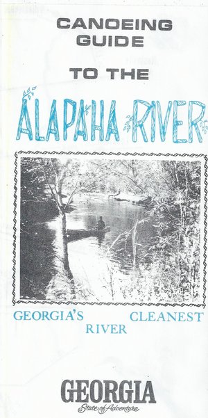 Here’s a different guide to the Alapaha River from the
one WWALS previously received; this one is
courtesy of John Leonard, Executive Director of the
Southern Georgia Regional Commission (SGRC).
The
Alapaha River Water Trail WWALS is currently developing
is merely a continuation of this more than three decade old
Alapaha Canoe Trail.
Here’s a different guide to the Alapaha River from the
one WWALS previously received; this one is
courtesy of John Leonard, Executive Director of the
Southern Georgia Regional Commission (SGRC).
The
Alapaha River Water Trail WWALS is currently developing
is merely a continuation of this more than three decade old
Alapaha Canoe Trail.
John Leonard said that when he started at the predecessor of the SGRC in 1980, calls came in frequently asking about water levels on the Alapaha River. It took him a while to realize why: the Alapaha River Trail had been written up in Southern Living! He did not have Continue reading
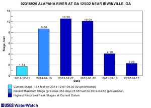
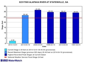
Alapaha River water levels
Update 2025-09-21: Graphs from water.noaa.gov.
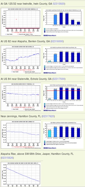 Update 2016-12-23: graphs from water.weather.gov.
Update 2016-05-31: See sea level gage reports.
Update 2015-04-28: Added flood stages and tentative highest safe and lowest boatable water levels, both above the charts for each gauge and in a summary table. If you have data, please let us know.
Here are water level gauges for the Alapaha River in Georgia and Florida, north to south. The graphs should show the current levels at this time, in feet, plus for most of the gauges a bar graph of selected historic levels.
This is a draft of a concept for use with the Alapaha River Water Trail. See also Alapaha River Rainy Season.
It is also a companion to the similar set of graphs for the Withlacoochee and Little Rivers.
See below for the current Alapaha River water level graphs. Continue reading
Bill Gates gobbling up Georgia farmland, too
 Update 2015-01-11: People seem confused as to what Bill Gates is doing.
However, since he announced in 2012 he was going to “fix” agriculture in conjunction with Monsanto and Syngenta, and he’s buying up hundreds and thousands of contiguous acres at a time, it seems pretty clear he’s promoting corporate pesticided GMO agriculture.
Update 2015-01-11: People seem confused as to what Bill Gates is doing.
However, since he announced in 2012 he was going to “fix” agriculture in conjunction with Monsanto and Syngenta, and he’s buying up hundreds and thousands of contiguous acres at a time, it seems pretty clear he’s promoting corporate pesticided GMO agriculture.
Update 2015-01-13: More Gates purchases in more counties.
Add Echols County and Lowndes County, Georgia, including much of Lake Park, and Hamilton and Madison Counties, Florida, in addition to what Amber Vann wrote in the VDT and other papers today 22 October 2014, Bill Gates gobbling up Florida farmland
LIVE OAK, Fla. — The investment company that manages the wealth of the world’s richest man, Bill Gates, has been acquiring gobs of farmland in north Florida the past two years, real estate records show.
Lakeland Sands Florida, a subsidiary of Cascade Investments LLC, which oversees the Gates fortune, recently bought more than 4,500 acres in Suwanee County near McAlpin, an unincorporated community just south of here.
 Meanwhile, Bill Gates owns Cascade Investment LLC,
which owns Los Arboles LLC,
which changed its name to Cottonwood Ag Management LLC,
which bought land in Echols County on the Alapahoochee River,
a year after Bill Gates said he was going to fix agriculture
in conjunction with Monsanto and Syngenta.
Meanwhile, Bill Gates owns Cascade Investment LLC,
which owns Los Arboles LLC,
which changed its name to Cottonwood Ag Management LLC,
which bought land in Echols County on the Alapahoochee River,
a year after Bill Gates said he was going to fix agriculture
in conjunction with Monsanto and Syngenta.
Cottonwood Ag Management LLC does not own any land in Lowndes, Hamilton, or Madison Counties. But Lakeland Sands does: Continue reading
1970s Alapaha River Trail
Thanks to Glenn Dowling of Georgia River Network for this flyer from the 1970s for an Alapaha River Trail on “Georgia’s Cleanest River”.
Front
CANOE GUIDE
to the
Alapaha
River TrailGEORGIA’S CLEANEST
RIVERGEORGIA
State of AdventureBack
Continue reading
Alapaha River at Statenville: January WWALS Outing
 Meet at the boat ramp/parking lot on the left just before you get to
Statenville heading east on Hwy 94 at 1:30. Boat launch is at 2. We will
paddle upstream for 30 to 45 min. and then float back down. The river
will likely be up, so it should be a work out.
Meet at the boat ramp/parking lot on the left just before you get to
Statenville heading east on Hwy 94 at 1:30. Boat launch is at 2. We will
paddle upstream for 30 to 45 min. and then float back down. The river
will likely be up, so it should be a work out.

 The river water temperature is currently
50 degrees Fahrenheit, so dress warmly.
The Alapaha River at Statenville is currently at
9 feet and rising, which is well above the level recommended by
Brown’s Guide for this river.
The river water temperature is currently
50 degrees Fahrenheit, so dress warmly.
The Alapaha River at Statenville is currently at
9 feet and rising, which is well above the level recommended by
Brown’s Guide for this river.
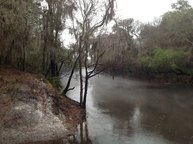
Jungle-like in its remoteness and luxurious with exotic vegetation, the dark reddish-brown waters of the Alapaha wind through a swampy wonderland teeming with wildlife. Signs of habitation are rare along the river’s course; only a few isolated cabins intrude on the remote tranquility.
Here’s a map: Continue reading
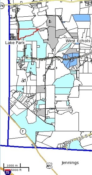
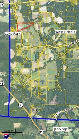
Alapahoochee River
 Proposed for the WWALS January 2014 outing:
the river most people know nothing about,
from the convergence of Mud Swamp Creek where Grand Bay Creek forms the border
between Lowndes County and Echols County in Georgia east of Valdosta,
about 14 miles through Echols County between Lake Park and Statenville,
to the Alapaha River in Hamilton County, Florida east of Jennings:
the Alapahoochee River.
Proposed for the WWALS January 2014 outing:
the river most people know nothing about,
from the convergence of Mud Swamp Creek where Grand Bay Creek forms the border
between Lowndes County and Echols County in Georgia east of Valdosta,
about 14 miles through Echols County between Lake Park and Statenville,
to the Alapaha River in Hamilton County, Florida east of Jennings:
the Alapahoochee River.
It has a waterfall, limestone caves, and boat ramps, all pictured by South Georgia Kayak Fishing 3 September 2011 in Alapahoochee convergence at Alapaha River – Jennings, FL.
 Here’s a brief day paddle description,
Florida whitewater, Alapahoochee River Grand Bay Canal),
by
riverfacts.com:
Here’s a brief day paddle description,
Florida whitewater, Alapahoochee River Grand Bay Canal),
by
riverfacts.com:
Echols / Hamilton county, GA SR 135 to FL SR 150 on Alapaha section whitewater kayaking, rafting, and paddling information.
This stretch of Alapahoochee River Grand Bay Canal) in Echols / Hamilton County is 4.5 miles long and is according to American Whitewater a class II section of whitewater.
They include a map.
