Tag Archives: Georgia

Judge Gives Sabal Trail Withlacoochee River Easement 2016-07-29

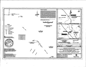
0.03 acres under the Withlacoochee River sold by the State of Georgia to Sabal Trail, operated by Spectra Energy of Houston, Texas, for $5,000, or $166666.66/acre. Map: Location That easement must be very valuable to Sabal Trail. 
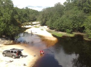
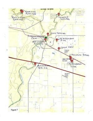
But it’s more valuable to us who live here and swim, fish, and boat on that river and drink from the Floridan Aquifer. If we’d known this was going on, some of us might have filed other documents in this case.

Also, I would have thought 666 once would have been enough.

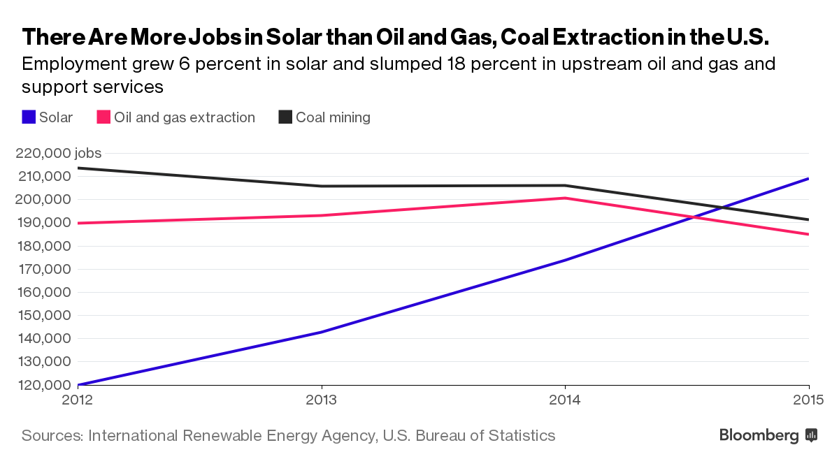
Here are some things you can do to help stop this boondoggle, and background about why this pipeline is a bad idea when there are already more solar jobs than in oil and gas extraction, and Georgia is the fastest-growing U.S. solar market.

Here’s the judge’s final order (PDF), followed by the other court documents in this case: Continue reading

Federal permits inflame opposition to Sabal Trail fracked methane pipeline boondoggle WWALS PR 2016-08-16

PDF FOR IMMEDIATE RELEASE

Hahira, Georgia, August 16th 2016 — There is no excuse for $3 billion down this rathole of a 20th century dying fossil fuel industry now that there are more solar power jobs than in all of oil and gas extraction. One federal permit Friday and another federal go-ahead impending for the Sabal Trail invasion of private property and wetlands in Georgia, Florida, and Alabama stiffens the resolve of the rapidly expanding opposition. WWALS Watershed Coalition (WWALS) has revealed apparent wetlands violations and federal rule violations by Spectra Energy, the Houston, Texas pipeline company that wants to gouge under our Withlacoochee and Suwannee Rivers, risking our water supply for its profit. Sierra Club has vowed to use “all legal means necessary to stop this fracked gas pipeline.” Opposition across Georgia continues as dozens of new groups joined the fight a week ago in Gainesville, Florida. News Friday of a U.S. Army Corps of Engineers (USACE) wetlands permit has inflamed opposition across the country to this latest fossil fuel land and water grab.

Last month WWALS reported to USACE and to the Federal Energy Regulatory Commission (FERC) that Sabal Trail already has Continue reading

USACE refuses Madison County’s request for a Sabal Trail SEIS 2016-07-29

They didn’t even bother to fill in the year on the date, and “File with original letter”. Here’s what the Corps wrote (PDF) in response to Madison County’s request for a Supplemental Environmental Impact Statement (SEIS) about Sabal Trail.

File with
original letter

DEPARTMENT or THE ARMY
JACKSONVILLE DISTRICT CORPS 0F ENGINEERS
POST OFFICE BOX 4970
JACKSONVILLE, FLORIDA 32232-0019

July 29, 201

USACE Response to Madison County re Sabal Trail Reply to attention of
Regulatory Division
North Permits Branch
Jacksonville Permits Section
SAJ-2013-03030

Madison Board of County Commissioners
Attn: Mr. Brian Kauffman, County Coordinator
Post Office Box 539
Madison, Florida 32341

Dear Mr. Kauffman:

Please accept this correspondence as Continue reading

Madison County, FL asks USACE for a SEIS 2016-07-18

This request for a Supplementary Environmental Impact Statement (SEIS), mentioning Madison Blue Spring in particular, was sent July 18th or 19th 2016, one copy to each of the Corps addresses. (PDF). That’s the fourth Florida county to make such a request, after Hamilton, Suwanee, and Marion Counties. The Corps already responded to Madison County.

Board of County Commissioners
Madison County, Florida

to express our concerns

Jacksonville Permits Section
U.S.A.C.E. Regulatory Division
Attn: Mark R. Evans,
  Senior Project Manager,
Post Office Box 4970
Jacksonville, Florida 32232

Commander, U.S.A.C.E.,
Savannah District
Attn: Mr. Terry C. Kobs
1104 N. Westover Boulevard, Unit 9
Albany, GA 31707

U.S.A.C.E.
Mobile District Reg. Div.
Montgomery Field Office
Attn: Mr. James S. Cherry II
605 Maple Street
Building 1429 Room 105
Maxwell AFB, AL 36112-6017


Norman C. Bay, Chairman Continue reading

State line to Sullivan Launch, Withlacoochee River 2016-10-09

Sunday morning on the tea-colored Withlacoochee River in north Florida in fall: come join us!

Shuttle When: 10AM Sunday October 9th 2016

Put in: Madison Highway on the Georgia side, also known as GA 31 Ramp (SRWMD) or State Line Ramp (GA DNR) or CR 145 Bridge Launch (FDEP). 30.635933, -83.311103

Directions: Continue reading

Road Closures in 2009 Flood, Lowndes County, GA

Back in 2009, Lowndes County spent hundreds of times more in infrastructure repairs than the $40,000 that Valdosta is asking as a match to build an online flood warning map, beyond just fixing sewer system spills to dealing with the rest of the flooding problem. Map of roads closed At recent meetings, some County Commissioners seemed reluctant to authorize the request because the proposed map mostly covers subdivisions in Valdosta. But the entire county was affected by road closures in 2009, so maybe Commissioners could ask to expand the map to cover the whole county, which could also help find sources of the flooding problem. Sources and effects extend all the way to the edges of the county, as you can see in this a google map I built back then:

Roads closed in Lowndes County, Georgia, as of 9:38 a.m April 6th, according to the Valdosta Daily Times. This map shows locations and terrain. It’s a Google map, so it’s interactive: you can zoom and pan and change to satellite view, street map, street view, etc. Some of the locations are guesstimates from the cryptic descriptions in the VDT article. The one green blob is the one reopening mentioned in the article: “North Valdosta Road Withlacoochee River Bridge opened at 10 p.m. Sunday.”

That VDT article no longer seems to be online, but this one is. Jason Schaefer, VDT, 27 April 2013, What natural events cost Lowndes taxpayers, Continue reading

Today: WWALS annual and board meetings, IHOP, Adel, GA 2016-07-13

This evening in Adel, come to the IHOP for the annual report and election of (some) board members at the WWALS membership meeting, and the annual election of officers and other business at the quarterly board meeting. 300x376 WWALS Rivers (small), in WWALS Rivers, by John S. Quarterman, for WWALS.net, 25 July 2015

When: 7PM WWALS Annual Meeting
7:30 PM WWALS Quarterly Board Meeting

Where: 1200 W 4Th St, Adel, GA 31620-2911
Here’s the IHOP’s own web page.

Agendas: See previous post

What: From the July 2016 Tannin Times, the WWALS membership newsletter: Continue reading

Rivers-Alive Cleanup at Berrien Beach Launch, Alapaha River 2016-09-10

No boat needed! This Rivers-Alive Cleanup is on land, at GA 168, the launch for Berrien Beach on the Alapaha River. Bring gloves. Trash bags will be supplied. 300x221 Public access on north side of bridge, with cement strip boat ramp at higher water level but no facilities. Access road is unpaved and about 1/4 mile long. Nice sandy beach., in Berrien Beach at GA 168 on the Alapaha River, by Bret Wagenhorst, for

When: 4PM Saturday September 10th 2016

Where: Berrien Beach Launch, at GA 168, 31.159076, -83.045554

Directions: 12.9 miles east of Nashville, GA on GA 168; launch access road is on left (north) side of highway west of the river.

Duration: about 1.5 hours.

Events: facebook, meetup.

Responsible party: Bret Wagenhorst

This outing is Free! But we encourage you to join WWALS today Continue reading

New hydrology report exposes Sabal Trail pipeline risk to Floridan Aquifer

FOR IMMEDIATE RELEASE

Jasper, Florida, July 1st 2016 — Another independent professional geologist reveals more omissions and discrepancies in pipeline company reports and faults in federal oversight of the Sabal Trail pipeline: Figure 7: Locations of the caves and springs mentioned in this study groundflow actually goes the other way, drilling under a river will change water flow in the Floridan Aquifer, and there is very high risk of sinkhole collapse. An indigenous Floridian commissioned this scientific report to protect his mother, the living earth. This geological report provides compelling additional reasons for the U.S. Army Corps of Engineers (USACE) to open a new process to evaluate this and other new information.

Bobby C. Billie, one of the Clan Leaders and Spiritual Leader, Council of the Original Miccosukee Simanolee Nation Aboriginal Peoples, asked professional geologist and hydrologist Peter Schreuder, P.G. to conduct investigations at the proposed Sabal Trail crossing under the Suwannee River from Hamilton County and under U.S. 90 in close proximity to the Falmouth Cave System in Suwannee County.

This Schreuder report concludes about the Floridan Aquifer System (FAS): Continue reading

Hydrogeologic Issues of Concern, HDD under Suwannee River –Peter J. Schreuder 2016-06-23

See press release, New hydrology report exposes Sabal Trail pipeline risk to Floridan Aquifer, and this report is also available in PDF.

Hydrogeologic Issues of Concern

Schreuder, Inc. Water-Resources & Environmental Consultants

Directional Horizontal Drilling (HDD) under the
Suwannee River
At Suwannee River State Park

Hydrogeologic Issues of Concern

In any review of potential environmental consequences related to the use of Horizontal Directional Drilling (HDD), both the geotechnical and scientific communities can be expected to raise serious concerns when such drilling is done around karst areas, and in regions which over lie the Floridan Aquifer System (FAS), which includes the Upper Floridan Aquifer, and the karstic geologic subsurface features at the location proposed in Continue reading