Tag Archives: I-75

Cow House Branch Lift Station Spill in Tifton, GA 2019 2017-09-11

Tifton spilled 277 times more sewage than Valdosta. Tifton Gazette, 20 September 2017, Power outage cause 250,000 gallon wastewater spill,

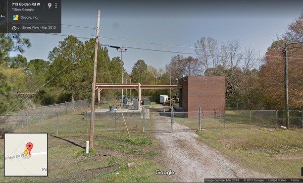
Street View, Golden Road Lift Station

TIFTON — There were 250,000 gallons of wastewater spillage due to the power outage cause by Hurricane Irma, according to Thomas Coker, water and wastewater superintendent.

The spillage occurred at Continue reading

Rivers Seven Days After Irma 2017-09-17

Looks like we may finally see Action stage tomorrow on the Withlacoochee River above Valdosta @ Skipper Bridge Road. This is upstream from Valdosta’s Withlacoochee Wastewater Treatment Plant, so it’s a good thing that didn’t spill during Irma. The Alapaha River at Statenville peaked Tuesday and probably would be a fine ride (what shoals?) today. The New and The Santa Fe Rivers are still flooding, and that’s still raising the Suwannee River all the way to the Gulf, and there’s minor flooding all the way up at Fargo, so another surge of high levels may follow on the Suwannee. The I-75 Santa Fe River bridge never did close.

2017-09-17 Withlacoochee River above Valdosta @ Skipper Bridge Road

The Suwannee River at White Springs peaked Continue reading

River Gage Projections after Hurricane Irma 2017-09-14

Update 2017-09-15: On the seventh day.

Update 2017-09-15: Added Suwannee River at Wilcox @ US 19, plus another image for the Gage Map.

Hurricane Irma flooded the Suwannee River at White Springs, the Santa Fe River especially at Fort White, with a new record for the New River new Lake Butler. It did not flood the Withlacoochee or Alapaha Rivers.

N2017-09-14 Suwannee River at White Springs
2017-09-14 Suwannee River at White Springs

FDOT says the I-75 bridge over the Santa Fe River Continue reading

Aerials: Woods Ferry Tract to Suwannee Springs 2016-11-23

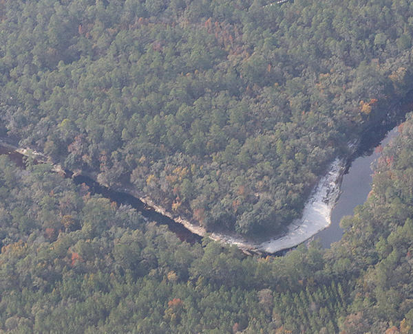
These aerial photographs by Beth Gammie cover the route of the Saturady 20 May 2017 WWALS Outing down the Suwannee River from Woods Ferry Tract Launch to Suwannee Springs. She took them for WWALS 23 November 2016, on a Southwings flight piloted by Roy Zimmer. They’re all looking from Hamilton County south (or west) across the Suwannee River into Suwannee County.

Woods Ferry Tract Launch

Woods Ferry Tract Launch

I have pulled out a few detail shots, of Woods Ferry Tract Launch and of Suwannee Springs.

Suwannee Springs bathhouse

Continue reading

Aerials: Sabal Trail hydrostatic test pond at I-75 @ WWALS 2017-02-07

Good questions by Janet Barrow. Who has answers?

Janet Barrow
March 13, 2017 at 4:55 pm

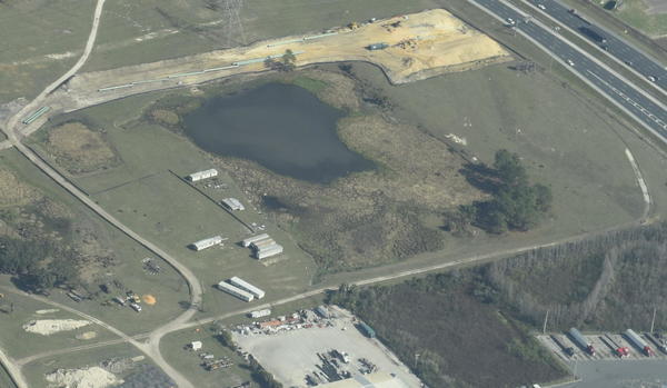
Look at the first photo — “Sabal Trail north from I-75 to the Withlacoochee (south) River.” This shows the hydrostatic discharge point for Spread 5 (at least the site they reported that they will use) and the withdrawal point for Spread 6. Coordinates are: 28°52’47.99″N, 82°5’39.69″W

Thanks to Mark Skogman’s long lens on the Southwings flight for WWALS, we can zoom in on that spot.

Hydrostatic test pond at I-75

Janet Barrow
March 13, 2017 at 5:07 pm

Continue reading

Aerials: I-75 to Withlacoochee (south) River 2017-02-07

Update again 2017-03-13:

Sabal Trail north from I-75 to the Withlacoochee (south) River.

Tommys Tire Shop, 418 FL-44, Wildwood, FL 34785,
Photo: Mark Skogman for WWALS on Southwings flight 2017-02-07

The Villages is about six miles northeast of where Sabal Trail crosses I-75 just north of FL-44.

Closeup, Withlacoochee (South) River crossing,
Photo: Jim Tatum for WWALS on Southwings flight 2017-02-07

Many more pictures below, and a Google Map showing the locations.

 -jsq, John S. Quarterman, Suwannee RIVERKEEPER®

You can join this fun and work by becoming a WWALS member today!

Pictures

Continue reading

Bevel Creek, not Beaty Creek, on Williams Road off Loch Laurel, Lowndes County, Georgia

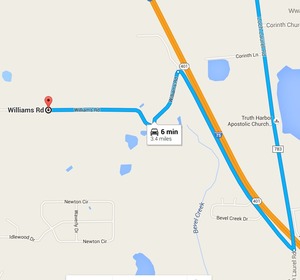
Mystery finally solved of where is the road over what creek does Lowndes County Georgia want to replace a bridge?

Loch Laurel Road to Williams Road --Google Maps Item 6.b. Replacement of Beatty Creek Bridge on Williams Road, for yesterday morning’s Lowndes County Commission Work Session: where is this for the $634,800 low bid from Southern Concrete Construction of Albany, GA? There are two Williams Roads in Lowndes County and no Beaty Creek. In the north end of the county Cat Creek has a tributary Beatty Mill Creek, with a Williams Road running near it between Upper New Bethel Road and Beatty Mill Creek Road. But according to all the maps I can find, Williams Road does not cross Beatty Mill Creek.

So what exactly is it that the county wants to pay the low bidder $634,800 for? In the 8:30 AM Tuesday 25 April 2016 Work Session, Commissioner Mark Wisenbaker asked, “Where exactly is this?” Continue reading

Ray’s Mill Pond; was Withlacoochee River: Langdale Park to Little River Boat Ramp 2016-04-03

Update 2016-03-31: Rescheduled for Ray’s Mill Pond, due to flood stage on the Withlacoochee River.

Back on the Withlacoochee River in Valdosta, by popular demand from last weekend’s outing! Shuttle: 10 miles or 15 minutes each way We’ll continue next weekend on the next leg down the Withlacoochee River on the Withlacoochee and Little River Water Trail.

Event: facebook or meetup.

When: 9AM Sunday April 3rd 2016

Put in: Continue reading

Swift Creek confluence with Suwannee River

Chris Mericle took this picture today, 20 December 2015, Map of Swift Creek entering the Suwannee River, just east of I-75, in the Swift Creek Conservation Area, in Hamilton County, Florida, at 30.3460222, -82.8268667. -jsq

Confluence with Suwannee River

Letter to Lowndes County Commission about Sabal Trail

Here’s the cover letter I sent to the Lowndes County Commission about the action letter to county commissions, text of which was appended. They meet tonight at 5:30 PM. -jsq

From: “John S. Quarterman”
Date: Sun, 07 Sep 2014 21:07:54 -0400
cc: wwalswatershed@gmail.com
To: “Joyce E. Evans”, Richard Raines, Crawford Powell, Demarcus Marshall, Clay Griner
Subject: Resolutions other counties have passed against Spectra pipelines

Dear Lowndes County Commissioners,

With FERC’s recent instructions to Sabal Trail adding three more pipeline alternates that could go through Lowndes County, Lowndes has become even more of a key county regarding that pipeline. Please see the appended letter signed by many groups and individuals for resolutions and an ordinance that other counties have already passed.

Thanks,
John S. Quarterman, President, WWALS Watershed Coalition, Inc. Continue reading