After
Albany on Monday,
the Moultrie, Valdosta, and Lake City FERC Sabal Trail hearings
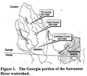
 are all in WWALS territory, and Sabal Trail’s fracked methane pipeline would cross
WWALS’ Okapilco Creek near Moultrie, Withlacoochee River near Valdosta, and Suwannee River near Jasper.
The Georgia DNR board Wednesday
gave away easements under those streams to Sabal Trail,
but they’re not permanent until at least two more state approval steps,
and they mean nothing if the pipeline is cancelled.
are all in WWALS territory, and Sabal Trail’s fracked methane pipeline would cross
WWALS’ Okapilco Creek near Moultrie, Withlacoochee River near Valdosta, and Suwannee River near Jasper.
The Georgia DNR board Wednesday
gave away easements under those streams to Sabal Trail,
but they’re not permanent until at least two more state approval steps,
and they mean nothing if the pipeline is cancelled.
The FERC meetings are all 5:30 PM speaker signup, 6 PM FERC presentation, then 3 minutes each per audience speaker, ending 8 PM.
-
Monday, September 28, 2015, at
Albany Civic Center, Meeting Room, West Oglethorpe, Albany, GA 31701
-
* Tuesday, September 29, 2015, at Colquitt County High School, Withers Auditorium, 1800 Park Avenue SE, Moultrie, GA 31776
-
* Wednesday, September 30, at Holiday Inn Valdosta, Conference Center Magnolia Ballroom, 1805 West Hill Ave., Valdosta, GA 31601.
-
* Thursday, October 1, at Columbia High School Auditorium, 469 SE Fighting Tiger Drive, Lake City, FL 32025
* Marks meetings in WWALS territory.
Why is the first Florida meeting in Lake City, when Sabal Trail
does not propose to go through Columbia County? Continue reading →

 You can sign a petition to Florida (or Georgia or Alabama) elected officials by
printing out the
PDF
for you and your neighbors.
See below for where to send them.
You can sign a petition to Florida (or Georgia or Alabama) elected officials by
printing out the
PDF
for you and your neighbors.
See below for where to send them.