Tag Archives: rain

More rain, more Valdosta WTP spills 2018-12-17

Update 2018-12-18: And a Florida Department of Health warning.

This is the first Valdosta spill press release that mentions the proposed additional catch basin. It still doesn’t acknowledge the other 13 spill locations from last time, nor does it say which, if any, of the previous spills was finally stopped.

I have requested an update from GA-EPD for what reports they have received, and I’ll post their response tomorrow. Meanwhile, you can sign the petition to ask GA-EPD to tell everyone when anyone spills.

Received 3:13 PM, Valdosta PR 17 December 2018, Weekend Storm Results in Sewer Overflow,

Buffer tank, Outside Withlacoochee WTP
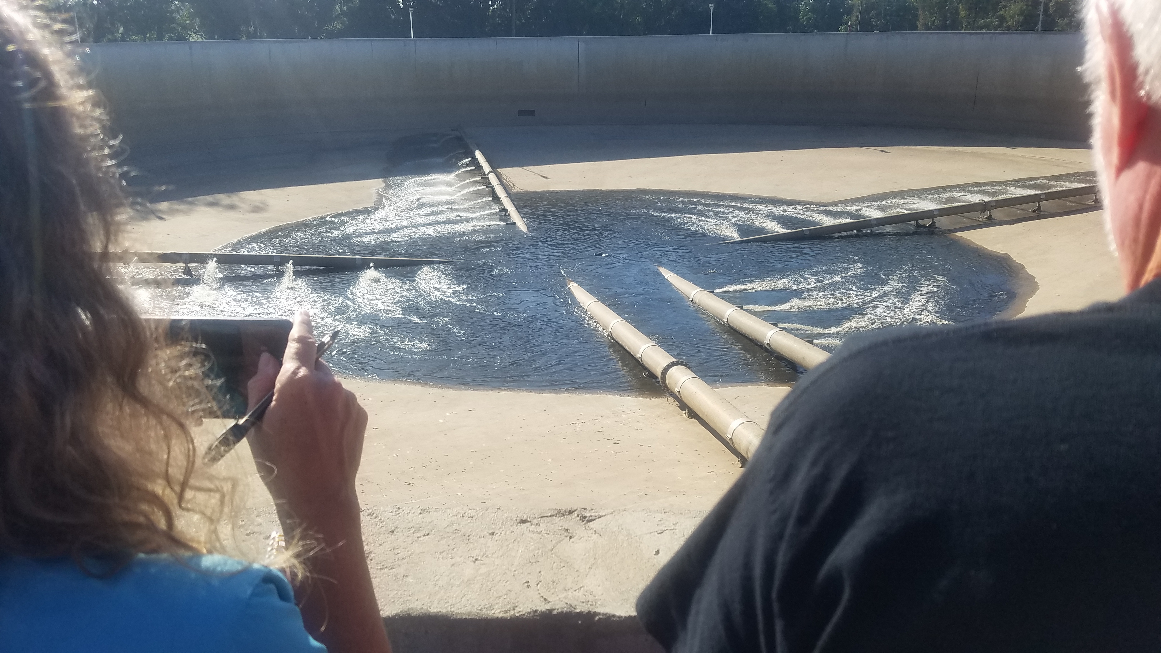
Photo: John S. Quarterman for WWALS, of one of four processing units, during WWTP tour, 3 October 2018.

During the past two weeks, The City of Valdosta and surrounding areas have received a combined total of 15 inches of rain during several storm events. Included in that total is the 3 to 4 inches of rain that Valdosta received over the weekend. During the most recent weekend rain event, city infrastructure operated as designed. While the WWTP has a normal average daily flow of 3.5 million gallons (MG), this past weekend, the influent flow peaked at more than 22 MG—nearly seven times the normal rate. As a result of recent rainfall totals into the plant, the structures were overwhelmed. The current system has four processing units, although during normal operations the system only requires one. During this storm event, the Withlacoochee Plant was running all four units plus the excess flow equalization basin. Additionally, the city is working with the Georgia Environmental Protection Division to design and install additional storage capacity at the facility.

On December 15 and 16, the City of Valdosta’s Withlacoochee Wastewater Treatment Plant identified intermittent sewage spills. The spill was caused by Continue reading

Yes, again, Valdosta WWTP Spill 2018-12-03

When I shared their press release on facebook last night, the best thing I could think of to say was: at least Valdosta told us as it is happening.

But why, Valdosta, why? Seriously, you’re not prepared for rain?

After Hurricane Michael barely missed Valdosta?

After only two months ago Valdosta Utilities assured us all they were prepared?

WWTP creeks, Map
Map: WWALS, Withlacoochee and Little River Water Trail.

And in a rain that submerged US 84 near the Withlacoochee River Bridge and washed out Old Lake Park Road you’re telling us nothing washed from the WWTP down the creek that goes directly to the Withlacoochee River? Continue reading

Valdosta rainbarrels to reduce runoff

Gretchen got a rainbarrel from the City of Valdosta, I got some concrete blocks, we set the barrel on the blocks and connected it to a PVC pipe from a raingutter. In about 20 minutes of rain, the 50-gallon rainbarrel was full. We don’t even live in Valdosta, but rainbarrels are also about preventing sewage spills; read on.

City of Valdosta Stormwater Division, Raining
Photograph: John S. Quarterman at Okra Paradise Farms, Lowndes County, Georgia.

Within an hour we had a hose hooked up and we used some of the water in transplanting trees.

Video, more pictures, and more links to materials from the city of Valdosta and the state of Georgia on a separate LAKE blog post.

Part of Valdosta’s incentive for this Stormwater Education Outreach can be inferred from Continue reading

Rain and Levels, Withlacoochee River, US 41 Gauge, Valdosta 2010-2018

The rainiest season in south Georgia and north Florida is the summer, yet that’s when rivers are usually the lowest. Here are seven years of data from the USGS Withlacoochee River Gauge at US 41 (North Valdosta Road) in Valdosta, Georgia. Rain is pretty steady through the year (except when there’s no rain), yet the river level varies wildly, highest in the winter, usually. Unless there are hurricanes in the fall, as happened in 2017 and 2016.

2010-2018, Rain Years
Rain Years 2010-2018

2010-2018, Level Years
Level Years 2010-2018

Why does this happen? Continue reading

FERC requires Sabal Trail report mixing of Randy Dowdy’s subsoil and topsoil

Bad news doubled for the little pipeline that cried wolf: FERC did not file any certificates today for Sabal Trail, and Brooks County farmer Randy Dowdy is vindicated with a letter from FERC demanding a plan from Sabal Trailwithin 20 days” (emphasis in the original) for “for investigating the actual extent of the topsoil and subsoil mixing on the Dowdy and Robinson properties and the reported mixing on the Jones property.”

Sabal Trail through Randy Dowdy fields and Little Creek, Google Map
Map: Google, of Sabal Trail pipeline through Randy Dowdy’s soybean fields, next to Little Creek, which runs into Okapilco Creek, into the Withlacoochee River, into the Suwannee, to the Gulf.

That letter refers to an inspection report of November 14, 2017, also filed by FERC today, that documents that “topsoil and subsoil mixing has occurred in agricultural areas during construction of Sabal Trail Transmission, LLC’s (Sabal Trail) Sabal Trail Pipeline Project.”

FERC has thus validated Continue reading

Fragility of monoculture agriculture in varying water conditions

They don’t want to say “we don’t know,” but they don’t know. At least they have a working hypothesis about the collapse of the 2017 peanut crop in much of Florida: it has to do with variations in rainfall.

Bob Kemerait, Southeast Farm Press, 22 January 2018, Peanut collapse: Something happened but it’s not clear exactly why,

…For months, University of Florida’s Institute of Food and Agricultural Sciences Extension agents led by Anthony Drew, Mace Bauer and Dee Broughton had been sounding the alarm that an unprecedented collapse of the peanut crop was occurring across large areas of Florida’s production region. Symptoms of this collapse included stunted plants, late-season yellowing and leaves with distinctive marginal leaf necrosis. Where most severe, entire fields wilted in the weeks prior to harvest. Abysmal yields, off by as much as 45 percent, forced some to consider their future in farming if solution could not be found.

During the latter third of the season, Continue reading

Valdosta WWTP manned 24/7 with backup generators before Hurricane Irma 2017-09-09

Don’t spill, Valdosta. Don’t leak, Sabal Trail. Hurricane Irma is bad enough already.

Valdosta announced its WWTP would be “manned around the clock”, so I called down there before 8AM this Saturday morning, and somebody did answer immediately. I told him as Suwannee Riverkeeper I was concerned for people downstream who don’t want any spills during the upcoming rains, so I was glad to see it was true they were there. I asked him if they had backup generators. He said yes. Of course, that doesn’t handle every manhole cover. We shall see. Don’t spill, Valdosta! (Or Lowndes County, or Tifton, or anybody else.)

NOAA NHC Rain Prediction, Hurricane Irma, 9 Sep 2017
Currently expecting somewhere between 4 and 10 inches of rain on Valdosta. Map from National Hurricane Center, 2017-09-09 8AM.

City of Valdosta, PR, 8 September 2017, Valdosta-Lowndes County Hurricane Irma Update, Continue reading

Small Valdosta sewer spills after big rains 2017-01-23

Update 2017-01-25: And also a spill at the WWTP.

Nobody likes sewer spills, but no, these are not the same as before Valdosta’s recent wastewater system improvements: Document-0001 nothing this time came from the Withlacoochee Wastewater Treatment Plant, and the amounts were small compared to previous years (10-62%) and in far fewer locations.

That didn’t stop WTXL from using this title: Amber Lewis, WTXL, 24 January 2017, Major Sewage Spill Reported in Valdosta,

The City of Valdosta has reported that a large amount of untreated sewage has spilled in the area.

The Florida Department of Health reports that Continue reading

Suwannee River Beach @ Spirit of Suwannee Music Park 2016-10-16

Stairs 30.4059372, -82.9478073 Very dry, and this was a week ago Sunday, with a bit more than 23 feet on the Nobles Ferry USGS gage. Surprisingly, the water’s not much lower now according to that gage.

Somebody asked us at Suwannee River Roots Revival: why is the Suwannee River so low? He was from the Atlantic coast of Florida, where they just had hurricanes, and didn’t realize: none of that rain fell upstream inland in Florida and Georgia up to the Okefenokee Swamp.

-jsq

You can join this fun and work by becoming a WWALS member today!

Continue reading

Rained out: Banks Lake Outing cancelled 2015-08-29

Expedition leader Chris Mericle conferred with John at Banks Lake Outdoors, Intellicast: South Georgia and they agree nobody wants boaters on Banks Lake in a thunderstorm, so tonight’s outing is cancelled. You probably figured that out already anyway, what with rain for an hour or more now and a 70% chance of thundersshowers at 7PM.

Chris would like to reschedule for Continue reading