
Follow this link for videos, more pictures, and a google map.

Follow this link for videos, more pictures, and a google map.

Follow this link for videos, more pictures, and a google map.

HWY 84 to Mayday.
What a great day for a paddle! The current was moving us along nicely, about 12 miles in just under 4 hours. It is a very beautiful stretch of river, very wild, many birds could be heard in the forest canopy.
cjm
This was the Hotchkiss Road to Mayday Outing.
More from Chris’s details in the Outings spreadsheet:
Hotchkiss road was washed out, put in at Naylor park property. Cut about .5 mile off of the trip.
Water level 85 on the Statenville gage. Was in the banks and moving quick. Would not recommend paddling at levels much higher than this.
Features: canopy over much of the river.
Flora: Tupelo, birch, oaks, pine, wild azalea. No invasive species seen.
Fauna: wood ducks, great egrets, kingfisher, heard- barred owls, hooded warblers, and many other birds.
Assessment: Very nice paddle. Very beautiful stretch of river
And a bit more from Chris:
Water level was high, much higher would not be recommended. Looking at the water level in comparison with the Safe Water Level criteria, Item 3 stood out. It became very apparent why it is important that you should be able to paddle against the current for a short distance. One of our paddlers needed a rescue and the only way to reach her was to paddle upstream.
-jsq
You can join this fun and work by becoming a WWALS member today!
Wondering why Valdosta is having an overflow problem? It was rain on Valdosta, and north of Valdosta.
Not so much northwest on the Little River, nor even west on Okapilco Creek: Continue reading
Chris Graham reported on facebook from the Alapaha River:
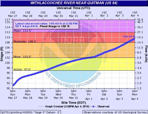
Here what the Alapaha River look like this afternoon near HWY 84 and CSX RR Track. Which it is high but it is going down tho.
The Alapaha was about 11.25 feet on the Statenville gauge at that time. Actually it kept going up. Today it’s at 13 feet.
We’ve been to that CSX railroad bridge before, Continue reading
Halfway between Quitman and Valdosta, the Withlacoochee River
 forms the border between
Brooks and Lowndes Counties, Georgia.
forms the border between
Brooks and Lowndes Counties, Georgia.
Parking on the median on the east, Lowndes County, side, you can climb down the highway rocks and down a creek bed to the river. Continue reading

For more pictures and a video, see other post.
Drilling down in Brooks County, under the Withlacoochee River,
 the CSX Railroad,
and Old Quitman Highway, surfacing in Lowndes County, Sabal Trail has moved its proposed Withlacoochee HDD crossing upstream.
The actual river crossing appears to be at about
30.795273, -83.452722.
the CSX Railroad,
and Old Quitman Highway, surfacing in Lowndes County, Sabal Trail has moved its proposed Withlacoochee HDD crossing upstream.
The actual river crossing appears to be at about
30.795273, -83.452722.
This is all according to Continue reading
Thirty-day comment periods closing 12 August 2015 to comment on
the US 84 widening project, say
 two Public Advisories from GA-EPD Watershed Protection Branch.
One is in
the Satilla River watershed, about
“two existing open water ponds
(outflowing into jusrisdictional[sic] wetlands associated with Lees Branch)”:
those ponds are next to the groundwater-contaminating CSX railyard in Waycross.
One is in
the Upper Suwannee River watershed, about
“three existing open water ponds
(outflowing into jusrisdictional[sic] waters associated with Greasy Creek and the CSX railroad)”.
Maybe the
Southern Environmental Law Center letter
to GDOT and the U.S. Army Corps of Engineers got some results,
although these advisories are from a different state agency.
two Public Advisories from GA-EPD Watershed Protection Branch.
One is in
the Satilla River watershed, about
“two existing open water ponds
(outflowing into jusrisdictional[sic] wetlands associated with Lees Branch)”:
those ponds are next to the groundwater-contaminating CSX railyard in Waycross.
One is in
the Upper Suwannee River watershed, about
“three existing open water ponds
(outflowing into jusrisdictional[sic] waters associated with Greasy Creek and the CSX railroad)”.
Maybe the
Southern Environmental Law Center letter
to GDOT and the U.S. Army Corps of Engineers got some results,
although these advisories are from a different state agency.
The Upper Suwannee one starts at Continue reading
This paragraph sums it up:
The project’s stated purpose in the EA is “economic development,” as part of the Governor’s Road Improvement Program created in the 1980s. See EA at 4. The NEPA regulations promulgated by the Council on Environmental Quality (“CEQ”) require agencies to examine the indirect impacts of projects — those growth-inducing impacts caused by a project, such as changes in land use and development patterns. 40 C.F.R. § 1508.8(b). Yet over and over, when purporting to examine the project’s potential for indirect impacts on various natural resources, the EA repeats, “The proposed project is not expected to precipitate substantial development along the corridor.”
Other questions include, why not use a narrower median? Why not leave trees on the median?
Below is the full text of the letter Continue reading