
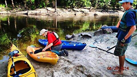
We launched @ Little River boat ramp in the VLCPRA area at GA 133.
So we headed
upstream about mile & half.
Continue reading
Category Archives: Maps
Biggest city in Suwannee River watershed?
 Apparently everybody knew this but me.
The biggest city in the entire
11,020 square mile Suwannee river basin,
half in south Georgia and half in Florida (that half being the largest river basin in Florida),
is…. Continue reading
Apparently everybody knew this but me.
The biggest city in the entire
11,020 square mile Suwannee river basin,
half in south Georgia and half in Florida (that half being the largest river basin in Florida),
is…. Continue reading
How Many Trees Does It Take to Protect a Stream?
Stroud Water Center wrote in their Upstream Newsletter, VOL. 2014, ISSUE 1, February 2014,
Scientists Set Buffer Width Minimum Standard.
A strip of forest along a stream channel, also called a riparian forest buffer, has been proposed and used for decades as a best management practice to protect streams by filtering out contaminants from agriculture and other land uses before they can enter them.Their benefits are many, but one benefit has dominated social and political conversations, and that is their role in preventing contaminants from entering streams.
A few years ago, Stroud Water Research Center proposed that riparian forest buffers also play another important role by Continue reading

Georgia Outdoor Map
 Interesting interactive map by
Georgia Department of Natural Resources,
Georgia Outdoor Map.
Their PR of 14 March 2014,
DNR Launches Interactive Map of Recreational Lands,
Interesting interactive map by
Georgia Department of Natural Resources,
Georgia Outdoor Map.
Their PR of 14 March 2014,
DNR Launches Interactive Map of Recreational Lands,
The Georgia Department of Natural Resources (DNR) today unveiled an interactive map that identifies DNR-managed lands and outdoor recreation opportunities. The “Georgia Outdoor Map” includes state parks, wildlife management areas, public fishing areas, boat ramps, and historic sites. Users are able to search by category to find locations where they can camp, hunt, hike, fish or explore history.
Continue reading
WWALS January 18-2014 outing review.
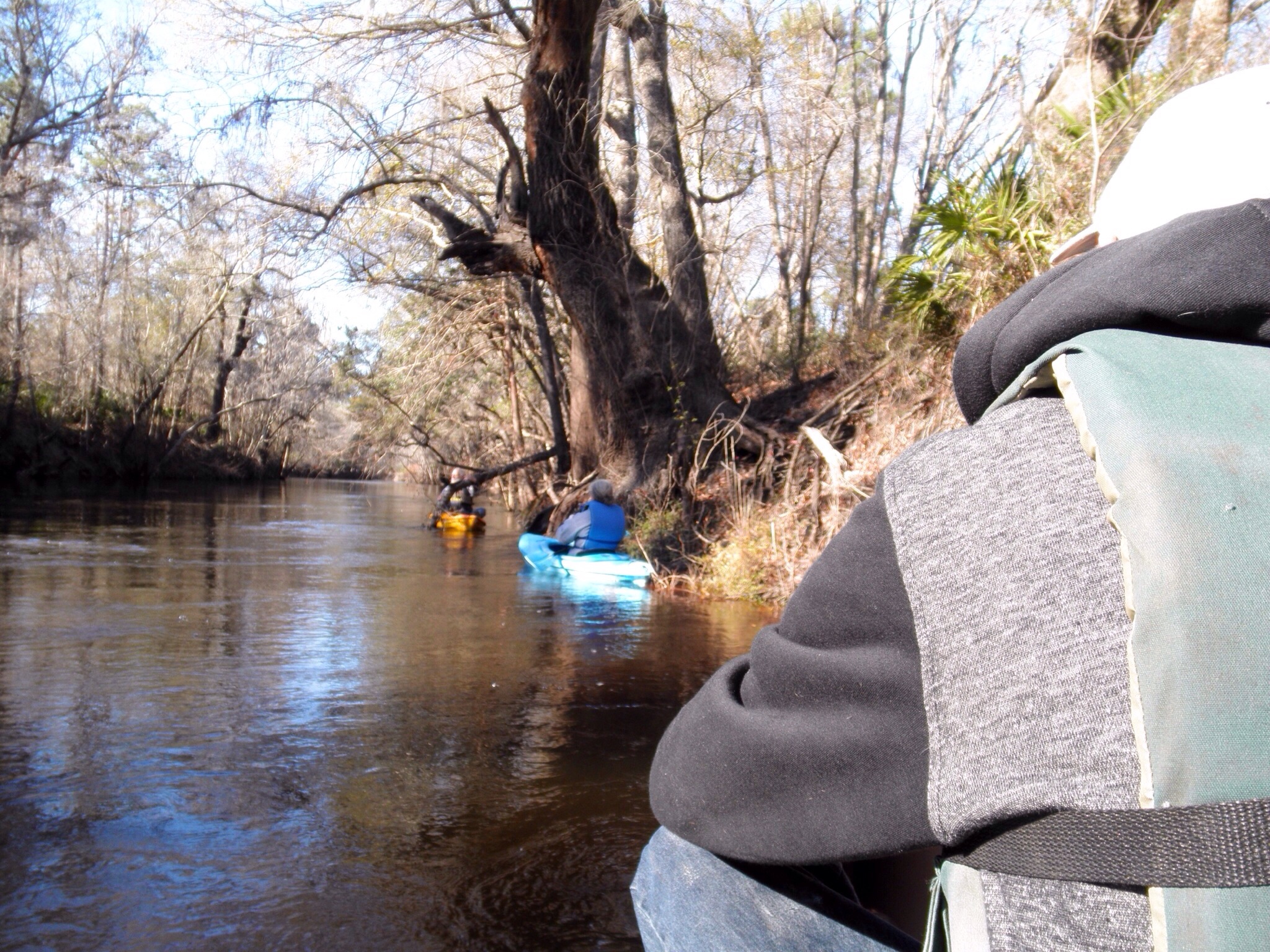 The WWALS outing was location in Statenville, Georgia DNR boat ramp on the Alapaha river. The water level @ the time of the outing was around 9 ft, but the river was within the backs. But the weather was sunny but cool day with a moderate wind. So the participants for this outing Continue reading
 Pipeline alternate route still in WWALS watersheds, plus Tifton and Valdosta
The Hillabee alternative route runs right down the middle of the WWALS watersheds, through Worth County, Turner County, Tift County, Colquitt County, Cook County, and Lowndes County in Georgia, and Hamilton County, Madison County, and Suwannee County in Florida. This puts it not only still in the Withlacoochee River watershed, but also in the Little River and Alapaha River watersheds. This route by the pipeline company Sabal Trail Transmission (owned and managed by Spectra Energy) avoids Albany but apparently goes through Tifton and Valdosta and still through Lowndes County before entering Florida in Hamilton County much like Spectra’s preferred route.
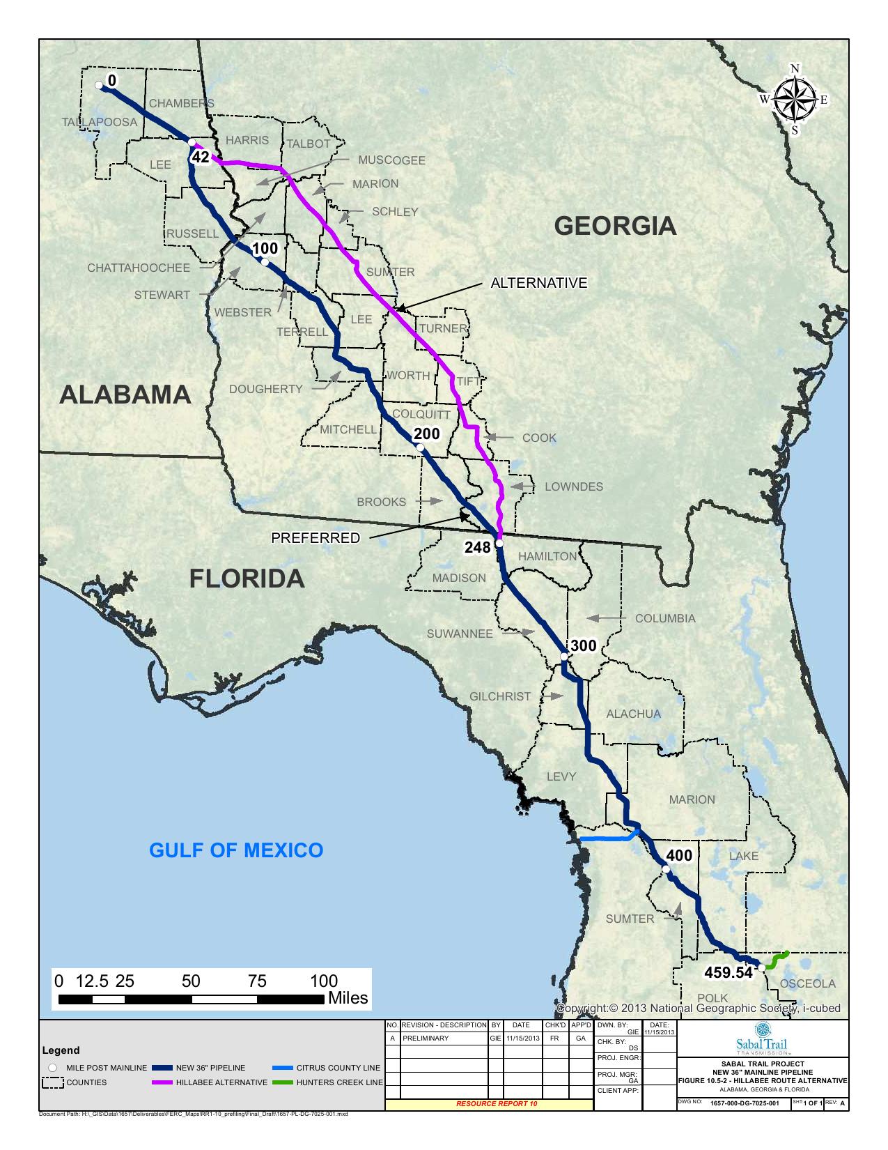

This alternate route is the rest of the Option B that was first proposed to Lowndes County residents back in June: Continue reading
Now at VSU: Aquifers, sinkholes, and ground scans –Don Thieme @ WWALS
Update 2019-04-02: Videos.
 Moved to VSU, University Center, Dogwood Room!
Prof. Don Thieme of VSU will speak about underground water issues
at the October WWALS board meeting in Wednesday October 9th at 7:30 PM
in Valdosta.
Join the
facebook event or come as you are.
Moved to VSU, University Center, Dogwood Room!
Prof. Don Thieme of VSU will speak about underground water issues
at the October WWALS board meeting in Wednesday October 9th at 7:30 PM
in Valdosta.
Join the
facebook event or come as you are.
Here’s the letter Prof. Thieme and two other VSU professors wrote to the Air Force about sinkholes and subsidence on the proposed Moody Family Housing in Lowndes County, which also turns out to be in an aquifer recharge zone.
Here’s VSU’s campus map and here’s a google map: Continue reading
Aquifers, sinkholes, and ground scans –Don Thieme @ WWALS
Moved to
VSU, University Center, Dogwood Room!
Prof. Don Thieme of VSU will speak about underground water issues
at the October WWALS board meeting in Wednesday October 9th at 7:30 PM
in
Adel at the IHOP, 1200 W 4th Street.
Valdosta.
Here’s the letter Prof. Thieme and two other VSU professors wrote to the Air Force about sinkholes and subsidence on the proposed Moody Family Housing in Lowndes County, which also turns out to be in an aquifer recharge zone.
It’s an open board meeting anyone can attend for the business part, as well. Here’s the agenda:
Agenda WWALS Board Meeting
7:30 pm October 9, 2013
IHOP, Adel GA
- Call to Order, Welcome and Introductions
Speaker: Don Thieme, VSU geologist. Topic: Aquifers, sinkholes, and ground scans.
- Agenda Review: Additions and Changes
- Review and Approval of Minutes of September Board Meeting
- Future Meetings and Events
- Monthly outing (fourth Saturday): October 26, 2013 at Banks Lake near Lakeland.
- Monthly board meeting (second Wednesday): November 13 Continue reading
JIA map shows all marsh as land at mean high tide –David Egan
 Received Thursday on
Marsh is not land, not here, not at Jekyll Island –WWALS Watershed Coalition -jsq
Received Thursday on
Marsh is not land, not here, not at Jekyll Island –WWALS Watershed Coalition -jsq
WWALS Watershed Coalition is on target with its analysis of the Jekyll 65-35 issue! Just a quick glance at the the 65-35 map under consideration by the JIA reveals all —- according to the JIA, ALL of Jekyll’s tidal marsh is above water, as in dry, at mean high tide, and is therefore part of the land area of Jekyll Islnsd subject to the 65-35 law. On-site conditions deny the accuracy of that map, for most of the marsh is actually under water (as in wet) at the time of high tide. The JIA’s map can be viewed at http://www.savejekyllisland.org/MPMOAAMHWPapJuly2013.html
-David Egan
SaveJekyllIsland.org wrote: Continue reading
Streamer on the Suwannee, Alapaha, and Withlacoochee Rivers: ten or more rivers and many creeks, lakes, swamps, and ponds
Update 3 March 2016: Suwannee River, ten rivers, and current location of USGS streamer.
The USGS Streamer interactive map shows all (well, most) tributaries of our two biggest WWALS rivers. Visitors sometimes refer to our “four rivers” since we only originally named four in our WWALS mission: Withlacoochee, Willacoochee, Alapaha, and Little. Yet we added the upper Suwannee, and there always were more than that: from one to ten rivers, depending on how you count them.
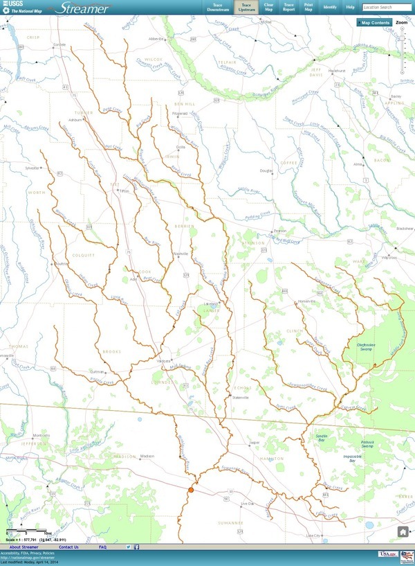
The Withlacoochee River tributary map here shows the New River south of Tifton joining the Withlacoochee between Nashville and Adel.
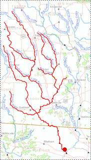
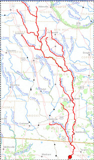
The New River is rather important, since it forms half of the boundary between Cook and Berrien Counties (the Withlacoochee River forms the other half): Continue reading