Tag Archives: Blueway

River Pictures by Bryan Garris for WWALS Water Trail Workshop @ VSU 2016-02-27

This Saturday, day after tomorrow, is the Withlacoochee and Little River Workshop at VSU! Wacissa tree Art exhibit and auction organizer Julie Bowland sent these pictures by Bryan Garris, saying:

I will have an assortment of painting sizes on easels. I’m thinking there will be around 20 easel works and a table full of matted photographs. There will be a minimum bid set by individual artists, with 20% going to WWALS.

You can also bring your own artwork or objects to donate to WWALS for auction. See you there! Continue reading

Pictures: Long Alapaha Outing, GA 135 to GA 168 2016-02-20

You never know on our blackwater rivers in south Georgia and north Florida. The danger! The thrill of the rapids!

After WWALS banner by Gretchen Quarterman OK, it was actually more like paddling on a lake with a current. The hardest part was when the wind picked up against us a few times. Sometimes we heard what sounded like rapids, but it was just flotsam lodged against oak trees.

But that’s the point: you really never know until you’re on the water, and on a trip like this with no good takeout until the end of the 18.25 miles, being prepared it much better than not.

The current did make for Continue reading

Expert paddlers get ready for Long Alapaha River Paddle, GA 135 to GA 168 (Berrien Beach) 2016-02-20

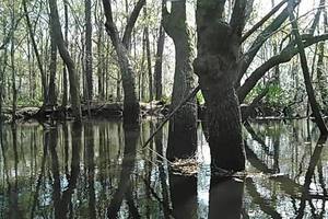
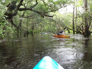
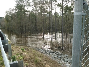
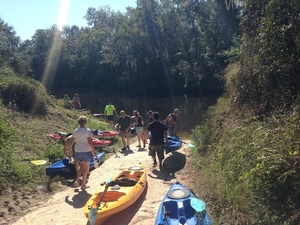
Update 2016-02-21: Actually it took 6 hours. Here are some pictures.

The water is high and fast, so expert paddlers only, arrive by 8AM at GA 135 (Atkinson County side), and be ready so we can shuttle quickly and get on the Alapaha River as soon as possible. 2015-02-19 to 2016-02-19 It’s a long way and we need to be off the river before dark. Berrien County Sheriff, game warden, and emergency response have all been advised of this trip, but expert paddlers only, please. As always, bring personal flotation devices, warm layers of clothes, drinking water, food, and a change of dry clothes. There is no good place to take out before the end point, so be prepared to paddle all day.

The USGS Gauge at Alapaha, GA shows 9.41 feet this morning, which is a good level. The Statenville gauge shows 17.32, which while well below flood level is also well above our usual recommended high of 9 feet. That Statenville gauge is quite a few river miles (56 miles) below our takeout point at GA 168, so the main bulk of rainfall in the river has apparently already moved downstream. But the water is very high and very fast. You will come up on any deadfalls or overhanging limbs quite quickly. Expert paddlers only. There are many other outings and events coming up that are much better suited for other paddlers.

2015-02-19 to 2016-02-19

Continuing our exploration of the entire Alapaha River Water Trail, Tall from Willacoochee we’re into the longer stretches, including this one.

Events: facebook, meetup.

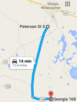
When: 8AM Saturday 20 February 2016

Put In: GA 135, MILE 106.5, Atkinson County side, 2.8 miles south of Willacoochee, GA, Atkinson County.

Take Out: GA 168 (Berrien Beach), MILE 88.24, N side of GA 168, west side of Alapaha River; float downstream under the bridge to the sand beaches, Berrien County

Duration: 18.25 miles. This paddle could take as long as 9-10 hrs.

Shuttle: Probably more than 30 minutes due to distance.

End time: Around 6PM. Yes, really all day.

Responsible party: Chris Mericle

This outing is Free! But we encourage you to join WWALS today to support our fun outings and important work: https://wwals.net/donations/. Continue reading

Workshop at VSU, Outings, Movie, and Hike to the Suwannee River –WWALS to Lowndes County Commissioners

Following up on the invitation I gave them in person last week, I sent this to the Lowndes County Commissioners just now, addressed to all five voting Commissioners, the Chairman, and the County Clerk:

Subject: Workshop at VSU, Outings, Movie, and Hike to the Suwannee River

Dear Commissioners,

Thanks again for the continued work on the Alapaha Boat Ramp, which will contribute to the quality of life recommended in the Comprehensive Plan.

As I mentioned at your Regular Session last week, you are invited to several WWALS events coming up soon, especially this one, which requires no boats: Continue reading

Hutchinson Mill Creek at Withlacoochee River, GA 122

Deadfalls on this creek, backing up flood waters onto Skipper Bridge Road forcing a bridge to close in 2009, Movie: Hutchinson Mill Creek (2.0M) 31.0155182, -83.3020477 were one reason for the formation of WWALS. Here are some pictures and a very brief movie.

In a typical day for a Waterkeeper®, starting slow after a road trip to Atlanta the previous day with several Riverkeepers and other environmental organizations, I was preparing for the movie in Live Oak Friday evening when I got a message from Noelani Mathews wanting an interview about the pipeline movie. As I threw a kayak in the truck, the Yellow Dog hopped in, and Continue reading

Pictures: Withlacoochee River, GA 122 to Franklinville Road 2013-04-20

One of the remotest segments of the Withlacoochee River, yet with easy access, and when the water was high enough. Unter den acer Also one of the least-attended WWALS outings, because we hadn’t really gotten the hang of announcing outings yet. But that just made it more intimate for the three of us who went. I got especially intimate with the river, choosing to swim twice. I always choose to swim when the water comes up to meet me…. Eventually I learned not to lean towards the side you’re tipping towards.

The closest USGS gauge is Continue reading

Skipper Bridge, 17.66 feet, flood level 15 feet

The water level continued up from yesterday, when it was Downstream 31.0116939, -83.2915878 17.66 feet on the USGS guage at Skipper Bridge in Lowndes County, Georgia at 9:46 AM when I took these pictures. Flood stage is 15 feet. It was so high you could have floated over the chain link fence the county put in when it replaced the bridge, thus preventing normal use of this bridge as a Withlacoochee River access point on the Withlacoochee and Little River Water Trail.

-jsq

You can join this fun and work by becoming a WWALS member today!

Downstream panorama 30.9016667, 83.2930556

Continue reading

Pictures: Withlacoochee and Suwannee Rivers, WWALS Outing, 2014-09-21

Gretchen Quarterman took these pictures on the Withlacoochee and Suwannee paddle: springs, shoals, and pipeline 21 Sept 2014. More people 30.4492111, -83.2214667 This was a long outing Chris Mericle organized down two rivers with many people, past springs, shoald, and sinkholes, and past the crossings formerly proposed by Spectra Energy for its Sabal “Sinkhole” Trail fracked methane pipeline before it moved upstream on the Suwannee, as seen 2015-08-15 and 2015-11-15. It was also before we started the Withlacoochee and Little River Water Trail. Click on any small picture below to see a larger one.

-jsq

You can join this fun and work by becoming a WWALS member today!

Continue reading

WWALS Water Trail trailers 7PM tonight at VSU CAUSES mini-film festival 2016-01-23

April Huntley submitted a 90-second video about the Alapaha River Water Trail, and Gretchen Quarterman sent one in about the BIG Little River Paddle Race on the Withlacoochee and Little River Water Trail. Come cheer for them and other local community entries, 7PM tonight, Bailey Auditorium, VSU, Valdosta, Lowndes County, Georgia.

-jsq

You can join this fun and work by becoming a WWALS member today!